

|
This 2002 photo shows the westbound Brooklyn-Queens Expressway (I-278) approaching EXIT 29 (Tillary Street / Manhattan Bridge) and downtown Brooklyn. (Photo by Jim K. Georges.) |
||
|
Length: |
||
|
10.4 miles (16.8 kilometers) for mainline and western leg |
||

|
THE BROOKLYN-QUEENS CONNECTING HIGHWAY: In 1936, the Regional Plan Association recommended the construction of a link between the Gowanus Parkway and the Triborough Bridge. Originally, this plan was devised as an alternative to a competing plan for a proposed Brooklyn-Battery Bridge (which eventually opened as a tunnel in 1950), and included the reconstruction of the Williamsburg, Manhattan and Brooklyn bridges. |
||
|
The "Brooklyn-Queens Connecting Highway," which was to be financed by Federal, state and city funds, was proposed as an express bypass through heavily built industrial, commercial and residential areas. It was to also provide a link from Brooklyn and Queens points to the East River crossings. |
||
|
This 1998 photo shows the westbound (southbound) Brooklyn-Queens Expressway over the Kosciuszko Bridge. The bridge, built by the city of New York in 1939, connects the Penny Bridge section of Queens with the Greenpoint section of Brooklyn. In the background are the two natural gas tanks owned by Brooklyn Union (now Keyspan Energy). These tanks, which had stood unused for nearly a decade, were imploded in 2001. (Photo by Jeff Saltzman.) |
||
|
SERVING INDUSTRIAL AND DEFENSE NEEDS: In 1940, New York City arterial coordinator Robert Moses recommended that the road, which he saw as a gap in the metropolitan arterial system, "should be filled immediately as an aid to the national defense." He went on the make the following case for the expressway: |
||
|
In 1940, Robert Moses recommended that the road, which he saw as a gap in the metropolitan arterial system, "should be filled immediately as an aid to the national defense." He further went on as follows: |
||
|
Brooklyn-Queens Connecting Highway: The portion of this route between Queens Boulevard and the Kosciuszko Bridge has recently been opened to traffic. North of Queens Boulevard to the Grand Central Parkway, the route has been mapped and is scheduled for early construction. It will provide express service for trucks and passenger cars from the Triborough Bridge to downtown Brooklyn. It will also provide for express service from LaGuardia Airport to the midtown Manhattan area via the recently completed Midtown Highway and the Queens-Midtown Tunnel. The section north of Roosevelt Avenue will form a northerly continuation of the proposed Middle Brooklyn-Queens Highway, and thus will be a link in a proposed circumferential route through the middle of Brooklyn and Queens from the Grand Central Parkway in Astoria, Queens to the Belt Parkway in Owl's Head, Brooklyn. |
||
|
There were some important differences in the city plan as follows: |
||


|
Two 1960 views of the newly opened Brooklyn-Queens Expressway near the Manhattan Bridge (left photo) and near the Brooklyn Navy Yard (right photo). (Photos by Triborough Bridge and Tunnel Authority.) |
||

|
MOSES AND THE BQE: In late 1945, Moses included the Brooklyn-Queens Expressway as part of his postwar arterial development program. Under his watch, the next section of the BQE, a stretch of six-lane elevated highway between the Williamsburg and Kosciuszko bridges, opened to traffic in 1950. This section of highway was built over Meeker Avenue, which was improved and widened just prior to World War II, and connected to the existing "Brooklyn-Queens Connecting Highway" to the north, which opened in 1939. |
||
|
In the following excerpt from his biography The Power Broker, Robert A. Caro described how Moses kept a watchful eye over the construction of the BQE: |
||


|
LEFT: This 2002 photo shows the eastbound Brooklyn-Queens Expressway (I-278) approaching EXIT 27 (Atlantic Avenue) in the Red Hook section of Brooklyn. (Photo by Jim K. Georges.) RIGHT: This 2001 photo shows the westbound Brooklyn-Queens Expressway (I-278) at EXIT 30 (Flushing Avenue), near the former Brooklyn Navy Yard. This section was reconstructed during the mid-1980's. (Photo by Christopher G. Mason.) |
||
|
MAKING DESIGN CONCESSIONS: In some locations, however, Moses had to make concessions. The original 1947 plan called for a six-lane, open-cut highway bisecting the community of Brooklyn Heights, similar to the configuration to the Red Hook community immediately south. In response to Moses' unpopular plan, community groups developed a "Citizen Alternative Plan" that proposed a three-decked structure immediately along the Brooklyn Heights waterfront. The structure was to carry three westbound lanes on the lower level, three eastbound lanes on the middle level, and a park and promenade on the upper level. |
||
|
Moses agreed to the "Citizen Alternative Plan" on the condition that the park and promenade, originally proposed for private gardens, would be open to the public. This eight-block-long cantilevered section, which opened in 1954, allows motorists to view the vast expanses of the lower Manhattan skyline and New York Harbor, while residents enjoy park space above the expressway. The engineering firm Andrews and Clark, a firm that Moses retained for his highway projects, constructed the expressway and promenade. |
||


|
Two 1998 views of the Brooklyn-Queens Expressway taken just south of the Brooklyn Bridge shows the beginning of the dual-level roadway. As the expressway traverses the community of Brooklyn Heights, the upper level carries eastbound I-278, while the lower level carries westbound I-278. (Photos by Jeff Saltzman.) |
||

|
I-278? OR I-87? In August 1958, the Brooklyn-Queens Expressway was designated Interstate 278, making it eligible for 90-percent Federal funding for completion of new sections and reconstruction of existing sections. For a brief period in late 1958, the expressway was proposed to carry the I-87 designation from EXIT 32 (Williamsburg Bridge / Metropolitan Avenue) north to the Triborough Bridge (and thence to the Major Deegan Expressway); I-278 was to begin at the Williamsburg Bridge exit and continue to the south and west. The state withdrew the proposed I-87 designation in April 1959, bringing I-278 back to the BQE in its entirety. |
||
|
COMPLETE, BUT OBSOLETE: The final section of the BQE in Brooklyn was completed in 1960 in the area of the Brooklyn Navy Yard. Four years later, the final section of the expressway in Queens, between EXIT 36 (NY 25 / Queens Boulevard) and EXIT 38 (NY 25A / Northern Boulevard) in Woodside, was opened to traffic. The 10.4-mile-long mainline expressway and 1.2-mile eastern wye (originally called the "Boody Street Connection") were constructed at a cost of $137 million. |
||

|
This 2001 photo shows the cantilevered Brooklyn-Queens Expressway (I-278), the Brooklyn Heights Esplanade, and the Brooklyn Piers from New York Harbor. (Photo by Tom Scannello.) |
||
|
RECENT IMPROVEMENTS: According to the NYSDOT, the Brooklyn-Queens Expressway handles approximately 160,000 vehicles per day (AADT) through the borough of Brooklyn, and approximately 120,000 vehicles per day through Queens. |
||
|
A ROAD STILL LURKING WITH DANGER: The projects underway underscored the need for motorists to proceed with caution through construction zones. On January 16, 2006, a tanker truck filled with 8,000 gallons of gasoline overturned and exploded on the eastbound lanes underneath a temporary construction bridge near Roosevelt Avenue. The temporary bridge over the BQE collapsed, and with the raging fire threatening the nearby Roosevelt Avenue overpass and trestle carrying the IRT #7 subway line, vehicular and train traffic was stopped, as was traffic on the BQE, for at least 24 hours. Fortunately, no one was injured seriously in the mishap. IS IT TIME TO TUNNEL THE BQE? In its 1999 research paper, "How To Build Our Way Out of Congestion," the Reason Public Policy Institute advocated replacing the elevated sections of the Brooklyn-Queens Expressway with a tunnel, citing high land values and local antagonism in the area. The proposed tunnel, which would be based on the new Paris "Metroroutes," would allow urban buses and most fire equipment, but not heavy trucks or long-distance coaches. Nevertheless, smaller vehicles that constitute more than 90 percent of rush-hour traffic flows would be permitted, allowing for considerable cost savings. |
||


|
Two 1998 views of the Brooklyn-Queens Expressway at EXIT 36 (NY 25 / Queens Boulevard) in Woodside, Queens, taken in the westbound / southbound (left photo) and eastbound / northbound directions (right photo). (Photos by Jeff Saltzman.) |
||
|
A LOVE-HATE RELATIONSHIP WITH THE BQE: Despite more recent improvements, the Brooklyn-Queens Expressway still falls short of Interstate standards in many areas. Ty Rogers, contributor to misc.transport.road, submitted the following excerpt to Scott Oglesby's "3di" site: |
||
|
I-278 (specifically, the Brooklyn-Queens and Gowanus expressways) has to be the worst excuse for an Interstate highway in the whole country. It is a series of different roads thrown together. Many entrance ramps have no acceleration lane at all and have "STOP" signs where they join the expressway. On the Grand Central Parkway, which is part of I-278 at the parkway's extreme western end, there is a sign saying "EXIT 4 (I-278 / Brooklyn-Queens Expressway)." To continue on I-278, one has to exit onto a single lane ramp. All this when I-278 should be the mainline and the Grand Central Parkway should be an exit of I-278. I know that there are many other examples around the country of having to exit in order to continue on the "mainline" Interstate, but the frequency of these problems collectively put I-278 in the hall of shame. |
||

|
Steve Riner, creator of the "Minnesota Highways" web site, opined the following in misc.transport.road: |
||

|
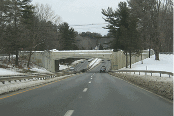
This 2005 photo shows the eastbound Brooklyn-Queens Expressway (I-278) at the newly renumbered EXIT 41 (NY 25A / Northern Boulevard) in Woodside, Queens. Prior to reconstruction, this interchange was EXIT 38. The New York Connecting Railroad trestle in this photo was relocated as part of the reconstruction project. (Photo by Alex Nitzman, www.aaroads.com.) |
||

|
For the Brooklyn-Queens Expressway and Gowanus Expressway portions of I-278, "NORTH" and "SOUTH" direction plates should be used. Interstate 278 actually runs north-south through Brooklyn and Queens, not east-west. |
||

|
SOURCES: "Freeways Are Now Urged," The New York Times (12/13/1936); "Highway Project Will Aid Queens," The New York Times (11/11/1937); "Vital Gaps in the New York Metropolitan Arterial System," Triborough Bridge Authority (1940); "Master Plan: Express Highways, Parkways and Major Streets," New York City Planning Department (1941); "Opening Set Today for Three Road Links," The New York Times (10/14/1950); "Dewey Speeds LI Expressway, Approves Bill To Add 64 Miles," The New York Times (3/27/1954); "Brooklyn-Queens Link To Be Completed Today," The New York Times (12/23/1964); Arterial Progress 1959-1965, Triborough Bridge and Tunnel Authority (1965); "Along the East River, Everything Old Is To Be Made New Again" by David W. Dunlap, The New York Times (3/02/2005); The Power Broker by Robert A. Caro, Vintage Books-Random House (1974); The Bridges of New York by Sharon Reier, Quadrant Press (1977); "New York: Chess in Concrete" by Bob Liff, The Newsday Magazine (12/04/1988); "Exit Strategies" by Clara Hemphill, Newsday (10/03/1999); "How To Build Our Way Out of Congestion" by Peter Samuel and Robert W. Poole, Jr., Reason Public Policy Institute (1999); "Inventory of Comparative Decking Projects," Parsons, Brinckerhoff, Quade and Douglas (2001); "Bridge of 'Size' May Have To Be Lowered" by Tom Topousis, New York Post (4/22/2002); "BQE Reconstruction Continues" by Andrew Thomas Klingle, The Queens Gazette (3/20/2003); "Parsons Brinkerhoff Providing CE&I Services for Brooklyn-Queens Expressway," Roads and Bridges Magazine (7/01/2005); "Digging Deep" by Andrew Moesel, The Queens Tribune (10/20/2005); "BQE Project Will Shift Traffic Until 2008" by Andrew Morsel, The Queens Tribune (11/17/2005); "Tanker Explosion Shuts Down Queens Highway and Subway," The New York Times (1/16/2005); "Smoke Pours From Tanker Truck Overturned On BQE," WNBC-TV (1/16/2006); DLand Studio; Kosciuszko Foundation; Net Resources International, Limited; New York City Department of Environmental Protection; New York Metropolitan Transportation Council; Tri-State Transportation Campaign; URS Creative Imaging; Phil Case; Ralph Herman; Gene Janczynskyi; Donghyun Kim; George Kowal; Dan Moraseski; Steve Riner; Ty Rogers; Jeff Saltzman; Tom Scannello; Mark Stauter; Stephen Summers; Mike Tantillo; Kevin Walsh; Douglas A. Willinger. |
||

|
BROOKLYN-QUEENS EXPRESSWAY CURRENT TRAFFIC MAPS: |
||
|
BROOKLYN-QUEENS EXPRESSWAY VIDEO LINKS: |
||

|
THE EXITS OF METRO NEW YORK: |
||

|
|
||

|
Back to The Roads of Metro New York home page. |
||
|
Site contents © by Eastern Roads. This is not an official site run by a government agency. Recommendations provided on this site are strictly those of the author and contributors, not of any government or corporate entity. |
||