

|
A NEW CORRIDOR FOR NORTHWEST QUEENS: From the 1930's through the 1960's, New York City arterial coordinator Robert Moses proposed an expressway along the Northern Boulevard-Astoria Boulevard corridor as an express route for commercial traffic through northwest Queens. Since the Grand Central Parkway could not accommodate trucks and buses, Moses proposed this expressway to carry this traffic between Flushing Meadow Park, LaGuardia Airport, the Triborough Bridge and the Queens-Midtown Tunnel. |
||
|
Moses considered the following alternative routes for the Astoria Expressway: |
||
|
|
||

|
Both proposals for the Astoria Expressway would have cut wide swaths through the long-established, heavily developed communities of Corona, Jackson Heights, Woodside and Astoria. |
||
|
In 1965, Moses announced specific plans for the expressway in Arterial Progress, a quarterly published by the Triborough Bridge and Tunnel Authority. The 2.4-mile-long, $38 million route was scheduled for completion by 1970. One year later, the Tri-State Transportation Commission echoed Moses' recommendation as follows: |
||
|
WAS THE PROPOSAL KEPT UNDER WRAPS? The furtive nature in which these plans had been developed unnerved New York City Traffic Commissioner Henry Barnes. On April 9, 1966, in an interview conducted by WPIX-TV (Channel 11), Barnes said the following: |
||
|
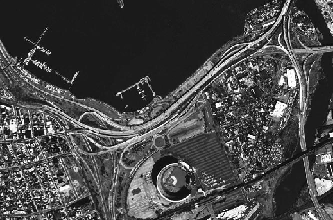
This 1975 aerial image shows the elevated highway connecting the Grand Central Parkway (on the left) with the Van Wyck and Whitestone expressways (on the right). The elevated highway replaced a ground-level parkway, and was planned to be part of the Astoria Expressway. (Photo by New York State Department of Transportation, provided by Nathan W. Perry.) |
||
|
TRUCKS ON THE GRAND CENTRAL? Meanwhile, Governor Nelson Rockefeller had for years recommended building four truck lanes along the Grand Central Parkway, a plan that was similar to his proposal for a "truckway" along the Belt Parkway in southern Brooklyn. While Rockefeller stated that he sought to relieve truck traffic through western Long Island, another reason why the governor sought to include trucks on the aforementioned sections of parkway was to make them eligible for Interstate funding. Upon completion of the expansion projects, the upgraded sections of the Grand Central and Belt Parkways were to become part of the Interstate highway system. |
||
|
Plans for a truckway through northwest Queens remained alive into the early 1970's. During a community board meeting held in early 1971, residents of Corona and Jackson Heights complained that the "truckway" proposal through their communities was "vague." Amid community opposition, Rockefeller reversed his recommendation for the truckways later that year. After this defeat, the I-678 designation was reassigned to the Van Wyck Expressway, between the Whitestone Expressway and Kennedy Airport. |
||
|
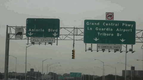
These 2002 photo shows the westbound elevated highway section between the Whitestone Expressway (I-678) and the Grand Central Parkway. Note the sign above the ramp for Astoria Boulevard. The space above the Astoria Boulevard sign was to be for an I-678 shield, and at one time had an Interstate shield. (Photo by Jon Lebowitz.) |
||

|
SOURCES: "Expressway Plans," Regional Plan Association News (May 1964); Arterial Progress 1959-1965, Triborough Bridge and Tunnel Authority (1965); "Phantom Highway a Puzzle to Barnes," The New York Times (4/10/1966); Transportation 1985: A Regional Plan, Tri-State Transportation Commission (1966); "US Agrees To Aid Lindsay Proposal for Linear City" by Richard Madden, The New York Times (6/29/1968); "Rockefeller Agrees To Drop Plan To Construct Truck Lanes," The New York Times (5/21/1971); The Power Broker by Robert A. Caro, Vintage Books-Random House (1974); Ralph Herman; Stephen Summers. |
||

|
ASTORIA EXPRESSWAY LINKS: |
||

|
Back to The Roads of Metro New York home page. |
||
|
Site contents © by Eastern Roads. This is not an official site run by a government agency. Recommendations provided on this site are strictly those of the author and contributors, not of any government or corporate entity. |
||