


|
THE NJ 26 / NJ 174 FREEWAY: The initial section of the Trenton Freeway stretched from the Trenton Toll (Trenton-Morrisville) Bridge north to Whitehead Road. Originally designated NJ 26, and later NJ 174, this section of freeway opened during 1952 and 1953. When it opened, planning officials held the Trenton Freeway as a successful example of arterial construction through a congested urban area. |
||
|
Through downtown Trenton, the pre-Interstate era expressway features four 12-foot-wide lanes (two in each direction) and 10-foot-wide shoulders, except where there are acceleration-deceleration ramps. A concrete ("Jersey") median barrier separates opposing traffic flows. According to the NJDOT, this section of US 1 carries approximately 50,000 vehicles per day (AADT). |
||
|
Pennsylvania officials sought at first to route I-95 across the Delaware River along the Trenton Toll Bridge, then north through Trenton along the Trenton Freeway. New Jersey, however, opposed this routing on the basis of the physical and capacity constraints on the four-lane bridge and freeway. The two states jointly investigated three alternative river crossings: Scudders Falls (west of Trenton), existing Trenton Toll Bridge-Trenton Freeway (through downtown), and Biles Island (east of Trenton). After further study, the two states approved the Scudders Falls alignment in 1960. Four years later, the BPR finally approved this more westerly alignment. |
||
|
EXTENSION AND RE-DESIGNATION: In 1967, the New Jersey Department of Transportation recommended a 1.5-mile-long extension of the NJ 174 Freeway. The expressway, which was extended north from Whitehead Road to the area of Baker's Basin, was designed to alleviate congestion at the Brunswick Avenue traffic circle. With its four 12-foot-wide lanes, 12-foot-wide shoulders and median separation, the extension was constructed to contemporary standards. According to the NJDOT, this section carries approximately 30,000 vehicles per day (AADT). |
||

|
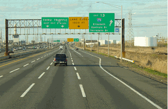
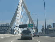
This 2003 photo shows the southbound Trenton Freeway (US 1) approaching Warren Street in Trenton. The original section of freeway from the early 1950's was rehabilitated during the 1980's. (Photo by Lou Corsaro.) |
||
|
SHOULD US 1 BE UPGRADED TO FREEWAY NORTH OF TRENTON? In 1983, soon after it received $245 million in Interstate trade-in funds from the cancellation of the Somerset Freeway (I-95), the NJDOT proposed building an additional travel lane in each direction, bringing US 1 to six lanes from I-295 in Ewing Township north to US 130 in North Brunswick. The project was one of six to be recommended after the cancellation of I-95. |
||
|
Two years later, the MSM Regional Council, which was established to plan the US 1 corridor through central New Jersey, made the following recommendations to the NJDOT: |
||
|
SOURCES: Transportation 1985: A Regional Plan, Tri-State Transportation Commission (1966); New Jersey Highway Facts, New Jersey Department of Transportation (1967); 1985 Regional Transportation Plan, Delaware Valley Regional Planning Commission (1969); "Interstate 95," Delaware Valley Regional Planning Commission (1979); "I-95 Corridor in the Tri-State Region," Tri-State Regional Planning Commission (1979); "Market-Based Solutions for Peak-Hour Congestion in the Trenton-New Brunswick Route 1 Corridor" by Meghan K. Fehlig, Princeton University (2002); Lou Corsaro; Raymond C. Martin; Dan Moraseski. |
||
|
US 1 FREEWAY LINKS: |
||
|
CURRENT METRO COMMUTE ROAD CONDITIONS: |
||

|
OFF-SITE EXIT LISTINGS: |
||
|
VIEW OR SUBMIT YOUR RATING TO RATETHEROADS.COM: |
||

|
|
||
|
Back to The Roads of Metro New York home page. |
||

|
Back to The Roads of Metro Philadelphia home page. |
||
|
Site contents © by Eastern Roads. This is not an official site run by a government agency. Recommendations provided on this site are strictly those of the author and contributors, not of any government or corporate entity. |
||