 |
|
|
|
|
|
|
|
|
|
|
|
|
|
|
|
|
|
|
|
|
|
|
|
|
|
|
|
|
|
|
|
|
|
|
|
|
|
|
|
|
|
|
|
|
|
|
|
|
|
|
|
|
|
|
|
|
|
|
|
|
|
|
|
|
|
|
|
|
|
|
|
|
|
|
|
|
|
|
|
|
|
|
|
|
 |
|
|
|
|
 |
|
 |
|
|
|
|
|
|
|
|
|
|
|
|
|
|
|
|
 |
|
|
|
|
|
|
|
 |
|
|
|
|
|
|
|
|
|
|
|
|
|
|
|
|
|
|
|
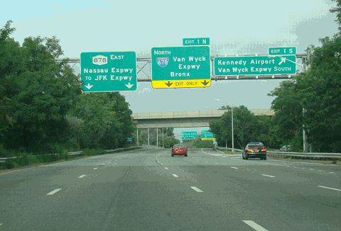
This 2014 photo shows the eastbound Nassau Expressway (NY 878) at EXIT 1 (I-678 / Van Wyck Expressway), along the northern perimeter of Kennedy Airport. Although NY 878 shields are posted along the controlled-access Queens section, there are small green "878I" NYSDOT reference markers posted on this section. (Photo by David Golub, www.eastcoastroads.com.)
|
|
|
|
|
|
|
|
|
 |
|
|
|
|
 |
|
|
|
|
|
|
|
|
|
3.8 miles (freeway in Queens)
2.7 miles (arterial in Nassau)
1965-1990
|
|
|
|
|
|
|
|
|
|
|
|
|
|
 |
|
|
|
|
|
COMING TO FRUITION: Since New York City arterial coordinator Robert Moses announced plans for this road in 1947, the Nassau Expressway has spent much of its life only on paper. Although the initial contracts were let out in 1949, it was not until 1963 that the City Planning Commission approved the initial section of the expressway. Construction began in 1965.
Towards the end of 1968, a one-way eastbound segment was completed between Cross Bay Boulevard and the Van Wyck Expressway (I-678) in southern Queens, running parallel to the Belt Parkway.
|
|
|
|
|
|
|
|
|
|
|
|
|
|
|
|
|
|
|
|
|
Even after the "I-78 through NYC" project was canceled in March 1971, the Nassau Expressway carried I-78 shields, but only on the overhead signs. For many years, this one-way segment was the only one open to traffic. In an interview, Queens Borough President Sidney Leviss called the segment "an adjunct to the Belt Parkway service road - what we have is only a double service road."
When the initial section of the Nassau Expressway section opened, The New York Times said the following:
At the northern end of Kennedy Airport, where the Southern (Belt) Parkway meets the Van Wyck, there is a huge sign strung over the highway that directs motorists to the Nassau Expressway. But motorists liken this to the gasoline-age equivalent of putting the cart before the horse.
Further construction stalled over environmental and community concerns over the next decade. After years of contentious public hearings and environmental studies, a compromise was reached between residents of the Five Towns area of southwest Nassau County and the New York State Department of Transportation (NYSDOT) in 1981. The Nassau County section of the route was constructed as a four-lane, at-grade arterial between Rockaway Turnpike in Inwood and the Atlantic Beach Bridge. This segment was completed in March 1990 at a cost of $28 million.
|
|
|
|
|
|
|
|
|
|
|
|
IS IT AN INTERSTATE, OR IS IT A STATE ROUTE? In 1989, the Nassau Expressway (which had been I-78) was re-designated I-878 in Queens, and NY 878 in Nassau County. (Near Kennedy Airport, there were signs for both I-878 and NY 878). One year later, the entire length of the expressway was re-designated NY 878. Despite the presence of NY 878 reassurance shields, there are NYSDOT "878I" reference markers along the Queens segment of the Nassau Expressway. The reference markers along this segment reflect its construction with Federal Interstate (90-10) funds, as well as its "I-878" listing in the 1998 FHWA route log.
|
|
|
|
|
|
|
|
|
|
|
|
|
|
|
|
|
|
|
|
|
|
|
|
|
In contrast, the Nassau County segment of the highway has NY 878 shields and NYSDOT "878" reference markers. This segment was constructed with 50-50 financing between the state and Federal governments.
A NEW NAME FOR THE NASSAU EXPRESSWAY? In 1998, Bruce Blakeman (R-Woodmere), presiding officer of the Nassau County Legislature, advanced a proposal to rename the Nassau Expressway after former President Ronald Reagan. Blakeman was unsuccessful in getting the New York State Legislature to approve the renaming of the highway.
RECENT IMPROVEMENTS: According to the NYSDOT, the Nassau Expressway handles approximately 60,000 vehicles per day (AADT) in Queens and about 50,000 vehicles per day in Nassau County
In 2000, the NYSDOT completed a $15.5 million resurfacing and rehabilitation of the Queens section of the Nassau Expressway; this included the replacement of the existing lightpoles with new ones. Three years later, the NYSDOT built a one-mile-long Rockaway-Idlewild bikeway from the Atlantic Beach Bridge north to Broadway in Lawrence. Long-term plans call for extension of this bikeway north into Queens, where it is planned to connect with the proposed Conduit-Southern Queens-Laurelton-Cross Island Greenway at 147th Avenue and Springfield Lane
In 2018, work began on $130 million reconstruction of the four-lane undivided Nassau Expressway section from Rockaway Turnpike south to Burnside Avenue, all located in the hamlet of Inwood. This 0.7-mile-long section was built in 1975 and was designated as the "Interim Nassau Expressway," but never was upgraded when the section to the immediate south opened in 1990. A new southbound roadway was built, while the existing northbound roadway, which had been subject to chronic flooding, was widened and raised by six to seven feet, such that it is now at least four feet above the floodplain. New turning lanes were added to the roadway, as will new lights and traffic signals. A new section of the Rockaway-Idlewild bikeway also was built alongside the roadway. Fast-tracked by Governor Andrew Cuomo following Hurricane Sandy in 2012, the project was completed in 2019, some six years ahead of schedule.
|
|
|
|
|
|
|
|
|
|
|
|
|
|
|
|
|
 |
|
|
|
|
|
|
|
|
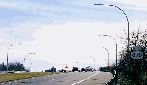
This 1998 photo shows the arterial section of the southbound Nassau Expressway (NY 878) , crossing over the LIRR Far Rockaway branch near the Inwood station. Note the NY 878 sign on the right. (Photo by Steve Anderson.)
|
|
|
|
|
|
|
|
|
|
|
|
|
|
|
|
|
|
|
 |
|
|
|
 |
|
|
|
|
|
|
|
|
|
MAPPING THE ROUTE: The Nassau Expressway, as planned as a limited-access highway in the late 1940s, was originally scheduled for completion in 1951. It was intended to run along the northern border of Idlewild (now Kennedy) Airport, and continue southeast along Rockaway Boulevard and Rockaway Turnpike to the Five Towns area of southwest Nassau County.
As the expressway entered Nassau County, it was to have interchanges at the following locations:
|
|
|
|
|
|
|
|
|
|
|
|
|
|
Rockaway Turnpike (slip and loop ramps)
Burnside Avenue (slip ramps)
Wanser Avenue (slip ramps)
Broadway (slip ramps)
Rock Hill Road / Meadow Causeway (trumpet interchange)
Seagirt Boulevard (trumpet interchange)
Crossing over the new Atlantic Beach Bridge, the Nassau Expressway was to continue east through Atlantic Beach, Long Beach, and Lido Beach before intersecting with the Loop Parkway in Point Lookout. The most likely alignment for the expressway would have been along a widened Park Street in Atlantic Beach (where there would have been flanking service roads), an elevated roadway along Park Avenue in Long Beach, and a raised roadway built atop oceanfront dunes along Lido Boulevard in Lido Beach.
The New York State Department of Public Works (NYSDPW) defined the route of the Nassau Expressway as follows:
Beginning at a point on the New York City line in the vicinity of the hamlet of Woodmere, thence running generally southerly to the Atlantic Beach Bridge in the vicinity of the village of Atlantic Beach.
Beginning at a point on the Atlantic Beach Bridge, thence running generally easterly to the Loop Parkway in the vicinity of the hamlet of Point Lookout.
|
|
|
|
|
|
|
|
|
|
|
|
In 1955, the Federal Bureau of Public Roads (BPR) included part of the Nassau Expressway - from the Bushwick Expressway-Cross Bay Boulevard interchange east to the unbuilt Clearview Expressway interchange - as part of the preliminary Interstate highway network. Three years later, the NYSDPW assigned the I-78 designation to the Interstate portion of the Nassau Expressway. According to a public notice posted to The New York Times in 1967, the Nassau Expressway would have received the NY 229 designation east of the Clearview Expressway.
|
|
|
|
|
|
|
 |
|
 |
|
|
|
|
|
|
|
|
|
|
|
|
|
Bill Joseph posted the following in misc.transport.road about the route of the Nassau Expressway in 1996:
As I understand from what my father told meilar to the Van Wyck Expressway (I-678), with most of the streets still connected on top by bridges. It was supposed to be like it is now between the Belt Parkway and the JFK Expressway, but then:
Run through the swamp-like land just east of Rockaway Turnpike, not on Rockaway Turnpike as it does now.
Cut under Rockaway Turnpike by Peninsula Boulevard, and continue on its current route (except sunken as opposed to grade-level) to the Atlantic Beach Bridge.
From the Atlantic Beach Bridge, continue through the city of Long Beach to the Loop Parkway in Lido Beach.
My parents grew up in Inwood, the town in Nassau County that was literally cut in half by NY 878. My father remembers that some 60 homes were condemned to make room for the road, while others were moved. The land sat vacant for more than 30 years before the road was built (in the late 1980s), and then it was just a quick paving job, with just a little buildup to get over the LIRR Far Rockaway Branch. To the best of my knowledge, there were no other areas that have been destroyed and not used.
THE CHALLENGE OF OBTAINING FUNDING AND RIGHTS-OF-WAY: In 1961, when right-of-way acquisition and demolition began along the route, the proposed ten-mile-long Nassau Expressway mainline was slated to cost $51.8 million. The eight-mile-long Long Beach extension was estimated to cost $41.4 million. At that time, the NYSDPW purchased 31 parcels of land for the right-of-way in Long Beach.
Significant community opposition helped kill the Long Beach extension in 1967, just as Moses was losing his highway-building clout on the city and state levels. (The rights-of-way were not sold until 1993.) From "Planners' Legacy: Long Island's Ghost Highways:"
Assemblyman Arthur K. Kremer (D, Long Beach) said proposals like the Long Beach Expressway showed arrogance. "It was a disaster for the community," recalled Kremer, who passed a bill killing the highway in 1967. "The problem was that the plans were drafted without talking to anybody."
From Morris Kramer, a Long Beach environmentalist and longtime resident:
One justification for it back in the 1950s was it was a possible escape route from New York City in case of a nuclear attack. I'm sort of glad that the expressway is dead, but ironically, we may need it in reverse as an evacuation route for this barrier beach island of 50,000 all-year-around people in the event of a disaster like a hurricane.
As early as 1969, the official map from the Tri-State Transportation Commission showed the then-incomplete Nassau Expressway as having the designation of "I-878," perhaps in anticipation of the cancellation of the Bushwick Expressway (I-78) that happened some two years hence.
By 1971, with only a partial two-mile segment finished, the rest of the expressway had an estimated date of completion in 1981, at a cost of more than $100 million. With the price tag rising to $140 million by 1974, NYSDOT officials proposed "90-10" Interstate funding for the incomplete portion of the expressway under a special "Federal urban high-density traffic" program. The Nassau Expressway Interstate funding proposal lost to segments in Arkansas, Indiana and Texas.
WHAT THE MUCK? In 1970, the NYSDOT issued bids on a 1.5-mile-long section of the Nassau Expressway between the Queens-Nassau border and Inwood. Construction of this segment would have required removal of "unsuitable" material - muck from a low-lying area near a tributary of Jamaica Bay - that could not moved from the site by conventional means because of pollution. Unlike material removed from most other sites, the muck had no resale value. The NYSDOT had estimated the cost for this section at $28 million, but on three separate occasions, no contractors were willing to bid at this price. To this date, this section remains part of the missing link on NY 878.
From Ralph Herman, frequent contributor to misc.transport.road and nycroads.com:
I remember that NYSDOT had actually put the Nassau Expressway section in Nassau County (in the area near Five Towns Plaza) out for bids. No bids were submitted because the contractors felt NYSDOT underestimated the difficulty in building this section on unstable landfill, and felt they would be liable for damages when the roadbed shifted.
In 1988, the NYSDOT estimated the cost of completing the missing link of the Nassau Expressway at $100 million. No immediate plans were developed for completing this section of expressway, resulting in what many residents of southwest Nassau call a "road to nowhere." More recently, the New York Metropolitan Transportation Council has called for studies of a "high-volume, limited-access highway leading to the Rockaway Peninsula." The extension of the Nassau Expressway on new alignment east of the existing section in Queens, as well as the conversion of the existing section in Nassau to a freeway facility, are mentioned as possibilities for construction beyond 2010.
EXTENDING THE WESTBOUND LANES: Since 1981, two versions of a plan to extend the westbound lanes of the Nassau Expressway to Cross Bay Boulevard in Howard Beach have been proposed. In 1995, officials revisited this proposal, which would also provide access to Aqueduct Racetrack. The $80 million extension, which had been scheduled for construction beginning in 1998, was shelved because of budgetary reasons and changing priorities. Specifically, the decline of racing at Aqueduct no longer created the racetrack-related delays of years past.
|
|
|
|
|
|
|
|
|
|
|
|
|
|
 |
|
|
|
|
|
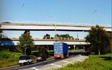
The western terminus of the Nassau Expressway (NY 878) in South Ozone Park. Original plans called for this road -- once part of I-78 -- to be extended west into Brooklyn as the Bushwick Expressway. Other connections were to be provided to the also-unbuilt Cross Brooklyn Expressway.
TOP:1965 artist's rendition by Triborough Bridge and Tunnel Authority.
BOTTOM: 1998 photo by Jeff Saltzman.
|
|
|
|
|
|
|
|
|
|
 |
|
|
|
|
|
|
|
|
|
|
|
|
 |
|
 |
|
|
|
|
|
The Nassau Expressway should be upgraded to freeway standards in Nassau County. Exits should be placed as per the 1959 Nassau County Master Plan. In addition, the "missing link" along Rockaway Boulevard through southeast Queens should be completed.
Once the conversion is completed, work should begin on a new Cross Brooklyn Expressway, utilizing the right-of-way along Conduit Boulevard, Linden Boulevard, and the LIRR Bay Ridge branch to the Gowanus Expressway (I-278). The combined Cross Brooklyn-Nassau Expressway facility should become the new I-878, creating a much-needed east-west truck corridor serving southern Brooklyn, southern Queens, southwest Nassau, and Kennedy Airport.
|
|
|
|
|
|
|
|
|
|
|
|
|
|
|
 |
|
|
|
|
|
|
|
|
|
|
|
|
|
 |
|
|
|
|
|
SOURCES: "Work Is Let To Start Nassau Expressways," The New York Times (5/06/1949); Master Plan for Nassau County," Nassau County Department of Public Works (1959); Regional Highways: Status Report, Tri-State Transportation Commission (1962); "Planning Group Backs New Road," The New York Times (4/19/1963); Arterial Progress 1959-1965, Triborough Bridge and Tunnel Authority (1965); "The Ocean Drive," Triborough Bridge and Tunnel Authority (1966); Transportation 1985: A Regional Plan, Tri-State Transportation Commission (1966); "10.6-Mile Nassau Expressway May Be Completed in 10 Years," The New York Times (3/21/1971); "Loss of US Aid To Delay Nassau Expressway Link" by Harold Faber, The New York Times (4/21/1974); "Nassau Expressway: Final Environmental Impact Statement Section 4(f) Statement Design Report," Federal Highway Administration and New York State Department of Transportation (1981); "Lee Koppelman: The Master Planner" by Marilyn Goldstein, Newsday (8/08/1986); "Ways To Go" by Alison Mithcell, Newsday (9/21/1986); "Planners' Legacy: Long Island's Ghost Highways" by William Bunch, Newsday (9/21/1986); "Back to the Future: LI Updating Master Plan" by Tom Morris, Newsday (3/20/1988); "Expressway Plan Receives Mixed Reviews" by Sharon Monahan, The New York Times (8/07/1988); "LI's Roads in a Big Jam" by Tom Morris, Newsday (2/22/1990); "Extension of Three Expressways Urged" by Monte R. Young, Newsday (2/22/1990); "Auction To Bury Road Plan" by Sid Cassese, Newsday (2/10/1993); "Road to Nowhere: Still No Return" by David M. Herszenhorn, The New York Times (9/03/1995); "Reagan Highway a Route To Focus on Alzheimer's?" by Irving Long, Newsday (2/22/1998); New York Metropolitan Transportation Council; Weidlinger Associates, Daniel T. Dey; Ralph Herman; Bill Joseph; Adam Levine; Jeff Saltzman; Dan Semaya; Jim Wade.
NY 878, I-78, and I-878 shields by Ralph Herman.
Lightposts by Jeff Saltzman.
|
|
|
|
|
|
|
|
|
|
|
|
|
|
|
|
|
|
|
 |
|
|
|
|
|
|
|
|
|
 |
|
|
|
|
|
|
|
|
|
 |
|
|
|
|
|
|
|
|
|
 |
|
|
|
|
|
|
|
|
 |
|
|
|
|
|
THE EXITS OF METRO NEW YORK:
Nassau Expressway exit list by Valerie Deane.
|
|
|
|
|
|
|
|
|
|
|
 |
|
|
|
|
|
|
|
|
 |
|
|
|
|
|
|
|
|
|
|
|
|
Site contents © by Eastern Roads. This is not an official site run by a government agency. Recommendations provided on this site are strictly those of the author and contributors, not of any government or corporate entity.
|
|
|
|
|
|
|
|
|
|