 |
|
|
|
|
|
|
|
|
|
|
|
|
|
|
|
|
|
|
|
|
|
|
|
|
|
|
|
|
|
|
|
|
|
|
|
|
|
|
|
|
|
|
|
|
|
|
|
|
|
|
|
|
|
|
|
|
|
|
|
|
|
|
|
|
|
|
|
|
 |
|
|
|
|
 |
|
 |
|
|
|
|
|
|
|
|
|
|
|
|
|
|
|
|
 |
|
|
|
|
|
|
|
 |
|
|
|
|
|
|
|
|
|
|
|
|
|
|
|
|
|
|
|
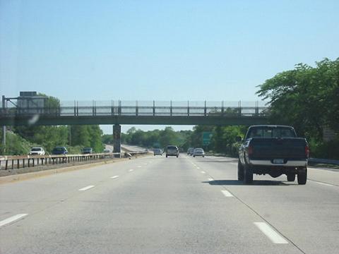
This 2002 photo shows the southbound Seaford-Oyster Bay Expressway (NY 135) just south of EXIT 4 (Southern State Parkway) in Wantagh. (Photo by Jon Lebowitz.)
|
|
|
|
|
|
|
|
|
 |
|
|
|
|
 |
|
|
|
|
|
|
|
|
|
|
10.8 miles (17.4 kilometers)
1959-1969
|
|
|
|
|
|
|
|
|
|
|
|
|
|
|
|
|
|
THE EASTERN NASSAU EXPRESSWAY: In 1954, the New York State Department of Public Works (NYSDPW) proposed a six-lane, north-south expressway between the Wantagh State Parkway in Wantagh and NY 106 in Oyster Bay. Unlike the route of the Western Nassau Expressway proposed two years earlier, the route of this eastern Nassau expressway was not yet densely populated, providing for an easier right-of-way acquisition process.
The route of the expressway was defined by the NYSDPW, and later amended by the New York State Department of Transportation (NYSDOT) as follows:
Beginning at a point on the Wantagh State Parkway in the vicinity of the hamlet of Wantagh, thence running generally through or near the hamlets of Seaford, Bethpage and Plainview to a point on state highway nine thousand twenty-one (NY 106) south of the village of Oyster Bay.
Beginning at a point on the Seaford-Oyster Bay Expressway as determined by the commissioner, thence generally northerly and northwesterly to a connection with the proposed bridge connecting Westchester and Nassau counties, including connections with existing highways. Notwithstanding the provisions of any local, general or special law, the last aforementioned highway or portions thereof may be built with control of access as determined by the commissioner.
MOSES CHALLENGED ON PLAN, BUT ULTIMATELY WINS OUT: The Seaford-Oyster Bay Expressway divided several Nassau County communities. Mike Tantillo, Long Island contributor to nycroads.com, posted the following in misc.transport.road about what happened in Plainview:
In 1954, my mother moved into a brand new house about a block away from the Seaford-Oyster Bay Expressway in Plainview. From what she and her father told me, the proposal was to have the expressway built north-south through the neighborhood. The right-of-way was purposely left developed as a strip of woods for several years before the expressway was constructed. Ultimately, an exit was constructed (EXIT 11 / Wallace Drive) for this neighborhood.
The expressway was so divisive that it was met with protest in each of the communities it was to pass. To mitigate community concerns, Oyster Bay Town Supervisor Lewis Waters suggested the following alternate route for the expressway:
Beginning at the Ocean Parkway in Tobay Beach, the expressway was to cross South Oyster Bay over a two and one-half mile causeway, touching down in West Amityville at Clocks Boulevard.
The expressway was to veer north-northwest near the current-day Sunrise Mall through Massapequa Park and Farmingdale toward Bethpage State Park.
|
|
|
|
|
|
|
|
|
|
|
|
|
|
|
|
|
Cutting a path across Bethpage State Park, the expressway was to use the right-of-way for the Bethpage State Parkway through Old Bethpage and Plainview, but then was to veer northwest toward the intersection Jericho Turnpike and South Woods Road in Woodbury about three-quarters of a mile east of the current NY 135 terminus.
The alternate route was to join the original route of the expressway near the LIRR Port Jefferson branch. However, the expressway was to end at NY 25A, not at NY 106 as in the Moses plan.
|
|
|
|
|
|
|
|
|
|
|
|
|
|
|
|
|
|
|
|
|
|
The plan supported by the Town of Oyster Bay was to take 185 homes, far fewer than the 450 homes in the Moses plan. However, the Moses plan ultimately won out.
DESIGN AND CONSTRUCTION: Right-of-way acquisition began in 1958, and construction commenced one year later. The section between EXIT 14 (NY 25 / Jericho Turnpike) and EXIT 10 (Old Country Road) was completed in 1962. The next section, between EXIT 10 and EXIT 4 (Southern State Parkway) was completed in 1963. With the opening of the section between EXIT 4 and EXIT 1 (Merrick Road) in the fall of 1969, the entire 10.8-mile route of the expressway was completed at a cost of $49 million.
Between EXIT 8 (Powell Avenue) and EXIT 9 (Broadway-Plainview Road) in Bethpage, the expressway has an unusually wide median covered with trees and bushes. Also, the southbound lanes are higher than the northbound lanes in this area. This was to be where the Seaford-Oyster Bay Expressway and the unbuilt portion of the Bethpage State Parkway were to connect. According to old maps, the southbound lanes of the Bethpage State Parkway were to have been in the median of NY 135 for about one-half mile before heading back southeast, while the northbound lanes of the parkway followed the northbound lanes of NY 135 along the right shoulder. This assumed that the Bethpage State Parkway would be upgraded from a "super 2" to a four-lane divided parkway, which never happened.
|
|
|
|
|
|
|
|
|
|
|
 |
|
|
|
|
 |
|
 |
|
|
|
|
|
|
|
|
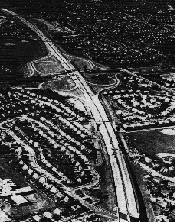
BACK IN TIME� LEFT: This 1965 aerial photo shows the Seaford-Oyster Bay Expressway (NY 135) nearing completion at EXIT 4 (Southern State Parkway) in Wantagh. (Photo by Triborough Bridge and Tunnel Authority.) RIGHT: This 1971 photo shows the southbound Seaford-Oyster Bay Expressway (NY 135) at EXIT 2 (NY 27 / Sunrise Highway) in Seaford. (Photo from Florida DOT Archives supplied by Robert V. Droz.)
|
|
|
|
|
|
|
|
|
|
|
|
|
|
|
|
|
|
THE SEAFORD-OYSTER BAY TODAY: Writing in The New York Times, Peter Austin Leavens described the expressway in the following excerpt:
The Route 135 road engineering is mostly consistent and in compliance with contemporary criteria. Sight lines are good. However, a few design faults mar its generally adequate configuration; for example, southbound at EXIT 6 into Boundary Avenue in Plainedge lacks any speed change deceleration lane, and the turn-off radius is short. Eventually, several principal exits could be modernized by conversion to direct taper takeoff ramps, as they are on the vast limited-access Sunrise Highway (Route 27) through Suffolk County. Ramp exits allow leaving the road at virtually full driving speed, and safer, diverging separation from conflict with the main lanes while slowing down.
Crossover accidents on Route 135 are comparatively rare. Nevertheless, a concrete ("Jersey") barrier and flush medians would be preferable to the existing old box rail and curbing. Lights should also be installed; vehicle density now justifies them.
Few changes have been made to the expressway since it was originally built. However, one notable change was made to one of its major interchanges. The interchange between the Seaford-Oyster Bay and Long Island expressways, which was originally built between 1959 and 1961, was reconstructed with new flyover ramps and overpasses in 1997. Also during the 1990's, the NYSDOT replaced the steel guardrail in the median barrier with a concrete "Jersey" median barrier. However, toward the end of the decade, officials killed a plan that would have returned the 65 MPH speed limit along the highway.
The NYSDOT has made the following improvements to the expressway:
The NYSDOT made operational and safety improvements at EXIT 2 (NY 27 / Sunrise Highway) in Seaford in 2002. To accommodate a reconfigured southbound EXIT 2W, the little-used ramp from the westbound Sunrise Highway to the southbound Seaford-Oyster Bay Expressway was closed permanently.
From 2012 to 2014, the NYSDOT undertook at $34 million project to rehabilitate and repave a four-mile-long segment from EXIT 1 (Merrick Road) in Seaford north to EXIT 7 (NY 24 / Hempstead Turnpike) in Bethpage. The project also included the installation of a concrete planted "Jersey" barrier, new signs, and other safety improvements.
The NYSDOT also proposed the erection of sound barriers from EXIT 10 (Old Country Road) north to EXIT 12 (Northern State Parkway) in Plainview. Although the $11.7 million project is on hold after being voted down in a community referendum, the state still has the project on its multi-year plans.
According to the NYSDOT, the Seaford-Oyster Bay Expressway handles approximately 90,000 vehicles per day (AADT).
AN EXPRESSWAY BY ANY OTHER NAME: When it was first built, NY 135 was known as the "Wantagh-Oyster Bay Expressway." In 1967, its name was changed to the "Seaford-Oyster Bay Expressway" not only to avoid confusion with the parallel Wantagh State Parkway just two miles to the west, but also upon the suggestion of residents to raise the profile of Seaford. Decades later, there were aborted attempts to rename the expressway after Theodore Roosevelt and Ronald Reagan.
On March 21, 2002, the highway was ceremonially named the "Ralph Marino Expressway" in honor of the longtime state senator. The renaming of the expressway for Marino seems somewhat ironic given his opposition to an extension of the expressway to Oyster Bay and the Oyster Bay-Rye Bridge. Marino died two weeks after the renaming ceremony.
|
|
|
|
|
|
|
|
|
|
|
|
|
|
|
 |
|
|
|
|
|
|
|
|
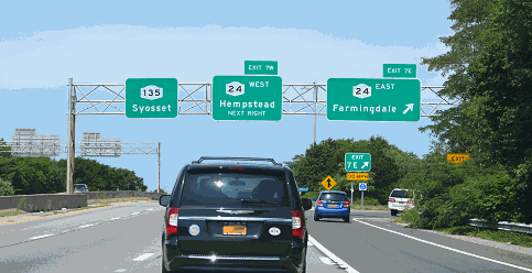
This 2004 photo shows the northbound Seaford-Oyster Bay Expressway (NY 135) at EXIT 7 (NY 24 / Hempstead Turnpike) in Bethpage. (Photo by Mike Chimeri.)
|
|
|
|
|
|
|
|
|
 |
|
|
|
|
|
|
|
|
|
 |
|
|
|
 |
|
|
|
|
|
|
|
NY 135 NORTHERN EXTENSION: The Seaford-Oyster Bay Expressway was intended to extend past its northern terminus in Syosset (at NY 25) to Oyster Bay, and ultimately across Long Island Sound to Rye in Westchester County to the Cross Westchester Expressway. Contingent upon construction of the "Long Island Sound Crossing," a project fervently pushed by Moses, all of NY 135 would have been redesignated I-287.
North of NY 25, the right-of-way for the Seaford-Oyster Bay Expressway went along the Syosset-Woodbury border to NY 25A. From here, the expressway was to have paralleled Berry Hill Road to NY 106 in the Village of Oyster Bay, the original terminus of the expressway. On its Master Plan map, the Nassau County Department of Public Works added (in red pencil) an extension of the expressway beyond NY 106 in Oyster Bay, then along West Shore Road and Ludlam Avenue to Bayville. This was to have been the right-of-way purchased for the Oyster Bay-Rye bridge approach.
In 1966, Moses pitched his $150 million Oyster Bay-Rye Bridge before the Nassau-Suffolk Regional Planning Board as the final link in the metropolitan beltway. Initially, Moses garnered the support of Governor Nelson Rockefeller. Two years later, when Moses ceded control of the Triborough Bridge and Tunnel Authority to the Metropolitan Transportation Authority (MTA), Rockefeller guaranteed that Moses would play a key role in getting the bridge built. The bridge proposal received additional support from the state in 1970, when it submitted plans for an extended I-287 across Long Island Sound and along NY 135 to the Federal Highway Administration (FHWA).
Immediately, strong opposition organized on both sides of Long Island Sound. The opposition found an ally in U.S. Senator Abraham Ribicoff, a Democrat and former governor of Connecticut. In 1972, Ribicoff sponsored a bill to turn part of the Oyster Bay wetlands into a bird sanctuary just as the NYSDOT and the MTA were releasing the bridge's draft environmental impact statement. Under newly enacted legislation, it became much more difficult to construct highways through Federally protected parklands and wetlands. On June 20, 1973, Rockefeller killed the Oyster Bay-Rye Bridge proposal in the face of opposition from residents and environmentalists.
Soon after the cancellation of the Oyster Bay-Rye Bridge project, the NYSDOT placed on hold plans to extend the Seaford-Oyster Bay Expressway from its northern terminus in Syosset. Despite this postponement, the Tri-State Regional Planning Commission recommended the NY 135 corridor as worthy of future study as follows:
With the abandonment of the Oyster Bay-Rye Bridge proposal, the need to extend the Seaford-Oyster Bay Expressway northward to NY 25A or NY 106 should be restudied.
NORTHERN EXTENSION MAY BE RECONSIDERED: In 1990, the Long Island Regional Planning Board proposed a multi-billion dollar plan to increase state and county highway capacity and bring all major roads to satisfactory levels of service by 2010. The board proposed that the Seaford-Oyster Bay Expressway be extended three miles north from its end at NY 25 to NY 25A (North Hempstead Turnpike), along rights-of-way purchased in the 1960's for the expressway.
A decade later, the NYSDOT reconsidered an extension of NY 135 north to NY 25A as part of the "LITP 2000" long-term plan to relieve congestion in the Syosset-Woodbury area. The extension may be constructed either as a "full-build" expressway, or as a four-lane arterial boulevard with traffic lights. The proposed extension awaits environmental study and public review.
North of NY 25A, where the Seaford-Oyster Bay Expressway would have formed the southern approach to the Oyster Bay-Rye Bridge, the NYSDOT sold the rights-of-way in the 1980s and 1990s. According to Eileen Peters, a spokesperson at the NYSDOT, there are no current plans to extend the expressway north of its current terminus at NY 25.
In 2007, a private consortium led by Polimeni Associates, a leading Long Island developer, proposed a 17-mile-long tunnel connecting the I-95 / I-287 interchange in Rye with the NY 135 / NY 25 interchange in Syosset. To mitigate the effect of building the southern approach to the tunnel, a 15-acre park would be built over the construction staging area along the Seaford-Oyster Bay Expressway. The park would feature ball fields, tennis courts, and other amenities.
NY 135 SOUTHERN EXTENSION: At its southern end, the Seaford-Oyster Bay Expressway was to extend south of EXIT 1 (Merrick Road) to the Wantagh State Parkway in the area of Cedar Creek Park. The four-lane link was to provide additional access to Jones Beach. Prior to 1967, some 25 families in Seaford had to be relocated for the purchase of 7.3 acres for the right-of-way.
As late as 1975, the Tri-State Transportation Commission recommended construction of this 1�-mile-long, $9 million link as follows:
Completing the Seaford-Oyster Bay Expressway from Merrick Road to the Wantagh State Parkway will close a gap in the limited-access system and remove traffic from congested arterials.
The NYSDOT shelved the southern extension of the Seaford-Oyster Bay Expressway around 1980, but held on to the right-of-way until 2004 when it sold the land to Nassau County. The county plans to build a multi-use trail connecting to the existing Wantagh State Parkway trail within the former right-of-way.
|
|
|
|
|
|
|
|
|
|
|
|
|
|
|
 |
|
|
|
|
|
|
|
|
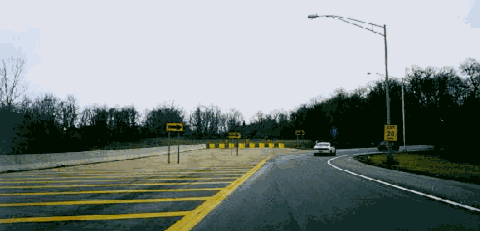
THE ROAD TO RYE? This 1998 photo shows the northern terminus of the Seaford-Oyster Bay Expressway at EXIT 14 (NY 25 / Jericho Turnpike) in Syosset. Over the years, the NYSDOT has considered a three-mile extension north to NY 25A. (Photo by Steve Anderson.)
|
|
|
|
|
|
|
|
|
|
|
|
|
|
|
|
|
|
|
|
|
|
|
 |
|
|
|
|
|
SOURCES: "New Route Urged for Expressway," The New York Times (3/12/1955); "Expressway Plan Stirs Oyster Bay" by Roy R. Silver, The New York Times (12/11/1957); "Master Plan for Nassau County," Nassau County Department of Public Works (1959); Regional Highways: Status Report, Tri-State Transportation Commission (1962); "Barnes Backs Ballard on New Expressway," New York World-Telegraph (7/08/1965); Arterial Progress (1959-1965), Triborough Bridge and Tunnel Authority (1965); Transportation 1985: A Regional Plan, Tri-State Transportation Commission (1966); "Report on the Status of the Federal-Aid Highway Program," Committee on Public Works, U.S. Senate (1970); A Comprehensive Transportation Study for Proposed Bridge Crossings, Creighton, Hamburg, Incorporated (1971); "Long Island Sound Crossing: Draft Environmental Section 4(f) Statement," Federal Highway Administration, Metropolitan Transportation Authority and New York State Department of Transportation (1972); "Governor To Cease Efforts To Build LI Sound Bridge," The New York Times (6/21/1973); "Veto or No, Route 135 Extension Is in Works" by Irving Long, The Long Island Press (6/21/1973); "Statewide Master Plan for Transportation," New York State Department of Transportation (1973); The Power Broker by Robert A. Caro, Vintage Books-Random House (1974); Maintaining Mobilization, Tri-State Regional Planning Commission (1975); "Lee Koppelman: The Master Planner" by Marilyn Goldstein, Newsday (8/08/1986); "Ways To Go" by Alison Mitchell, Newsday (9/21/1986); "Planners' Legacy: Long Island's Ghost Highways" by William Bunch, Newsday (9/21/1986); "Back to the Future: LI Updating Master Plan" by Tom Morris, Newsday (3/20/1988); "Nassau Lists Road Priorities" by Tom Morris, Newsday (9/27/1988); "Reassessing Robert Moses: The Legacy of a Power Broker," The Newsday Magazine (12/04/1988); "LI's Roads in a Big Jam" by Tom Morris, Newsday (2/22/1990); "Extension of Three Expressways Urged" by Monte R. Young, Newsday (2/22/1990); "Route 135: Dead End at Both Ends" by Peter Austin Leavens, The New York Times (3/25/1990); "Blakeman Picks New Road To Rename" by Ken Moritsugu, Newsday (1/15/1998); "Chasing Drivers" by Hugo Kugiya, Newsday (4/29/1999); "Concerns of Development Addressed" by Dagmar Fors Karppi, The Oyster Bay Enterprise-Pilot (9/10/1999); "Highway Hopes That Faded" by Sidney C. Schaer, Newsday (11/05/1999); "Fork in Road Over What To Do with Land" by Joseph Mallia, Newsday (4/27/2001); "Seaford-Oyster Bay Expressway Renamed "Ralph J. Marino Expressway" by Denise D'Alessandro, The Plainview-Old Bethpage Herald (3/22/2002); "Wrong-Way Road Signs: Still Wrong" by John Valenti, Newsday (6/18/2003); "Sound Tunnel Would Link Rye, Long Island" by Greg Clary, The Journal-News (11/21/2007); "Toll Tunnel Under Long Island Sound Proposed" by Peter Samuel, Toll Roads News (11/26/2007); "For a Tunnel To Go 16 Miles, No Light Yet" by Peter Applebome, The New York Times (11/29/2007); "Developer: Study Could Sink Long Island Tunnel" by Susana Enriquez, Newsday (1/24/2008); New York Metropolitan Transportation Council; Russ Blau; Daniel T. Dey; Dan Frost; Ralph Herman; Douglas Kerr; Nick Klissas; Chris Lindley; Scott Oglesby; Mike Tantillo; Jim Wade.
NY 135 and I-287 shields by Ralph Herman.
Lightpost by Millerbernd Manufacturing Company.
Speed limit sign by C.C. Slater.
|
|
|
|
|
|
|
|
|
|
|
|
|
|
|
|
 |
|
|
|
|
|
|
|
|
|
 |
|
|
|
|
|
|
|
|
|
 |
|
|
|
|
|
|
|
|
|
 |
|
|
|
|
|
|
|
|
 |
|
|
|
|
|
THE EXITS OF METRO NEW YORK:
Seaford-Oyster Bay Expressway exit list by Valerie Deane.
|
|
|
|
|
|
|
|
|
|
|
 |
|
|
|
|
|
|
|
|
 |
|
|
|
|
|
|
|
|
|
|
|
|
Site contents © by Eastern Roads. This is not an official site run by a government agency. Recommendations provided on this site are strictly those of the author and contributors, not of any government or corporate entity.
|
|
|
|
|
|
|
|
|
|