
|
|
||
|
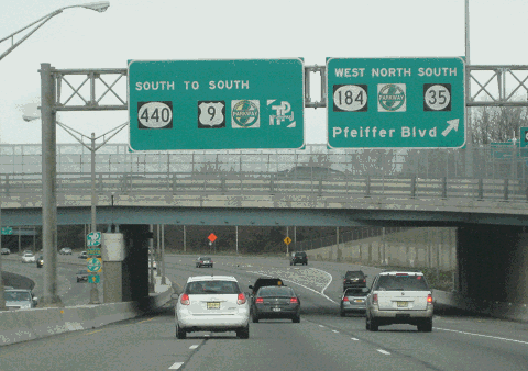
This 2012 photo shows the southbound NJ 440 Freeway at the exit for NJ 184 (Pfeiffer Boulevard) and NJ 35 (Convery Boulevard) in Perth Amboy. (Photo by Steve Anderson.) |
||
|
Length: |
||
|
5.2 miles (8.3 kilometers) |
||

|
EXTENDING THE METROPOLITAN BELTWAY TO STATEN ISLAND: The southern section of the NJ 440 Freeway had been planned since 1929 as part of an express route that was to link the Outerbridge Crossing with NJ 35, US 9, US 1, and US 22. The express route was conceived initially as part of a metropolitan beltway advocated by the Regional Plan Association (RPA). |
||
|
During the early 1930's, planners proposed a controlled-access "Edison Memorial Parkway" that was to connect US 22 in Watchung with the Edison Memorial Tower in Edison, the Edison Bridge (US 9) in Woodbridge Township and the Outerbridge Crossing. The parkway, which was to have bridle paths and scenic overlooks, was canceled by the ongoing Great Depression. However, planning continued for an east-west highway through Middlesex County after traffic studies revealed the need for an express route between the Outerbridge Crossing, US 9, US 1, and US 22. |
||
|
In 1970, a massive interchange between the NJ 440 Freeway, I-287, the New Jersey Turnpike and the Garden State Parkway - locally known as "Spaghetti Junction" - was opened to traffic. (Other local roads such as Smith Street, Crows Mills Road, New Brunswick Avenue and Industrial Highway are included in the massive interchange, which comprises more than 50 different roads, ramps, overpasses and jughandles.). By 1972, the entire length of the freeway was completed. |
||
|
A CASE OF TWO IDENTITIES: The NJ 440 designation is co-designated with CR 501 through Middlesex County, and both shields appear along the route. After NY 440 made its way through Staten Island, both designations were to reappear at the northern approach of the Bayonne Bridge, with the NJ 440 Freeway continuing north along the eastern shore of Newark Bay to Jersey City. (Interestingly, the 1958 AAA map of Metropolitan New York showed both NY 440 and CR 501 designations through Staten Island.) Although the northern section of the NJ 440 Freeway was canceled in 1977, the NJ 440 continues north through Bayonne and Jersey City along the former NJ 169. |
||
|
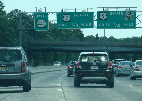
This 2014 photo shows the northbound NJ 440 Freeway approaching the exits for the Garden State Parkway and US 9 in Edison Township. (Photo by David Golub, www.eastcoastroads.com.) |
||


|
The current Route 440 through New Jersey and New York should be re-designated Interstate 395. Some posters in misc.transport.road have suggested that Route 440 in New York and New Jersey should become part of an extended Interstate 287 beltway. However, in the words of William F. Yurasko, doing so would create a "dyslexic nightmare." The I-395 designation is not used in either New York or New Jersey. |
||

|
SOURCES: Joint Study of Arterial Facilities, The Port of New York Authority and the Triborough Bridge and Tunnel Authority (1955); "Middlesex Freeway," New Jersey State Highway Department (1956); Regional Highways: Status Report, Tri-State Transportation Commission (1962); Transportation 1985: A Regional Plan, Tri-State Transportation Commission (1966); New Jersey Highway Facts, New Jersey Department of Transportation (1967); "Jersey State of Mind: On Top of Spaghetti Junction" by Peter Genovese, The Star-Ledger (11/17/2000); "Toll-Hike Plan for NJ Gets Jeered Here" by Maura Yates, The Staten Island Advance (1/09/2008); North Jersey Transportation Planning Agency; Chris Blaney; Frank Curcio; Arthur Malkin; Raymond C. Martin; Christopher G. Mason; Dan Moraseski; Mike Romero; Al Tossoonian; Gerard Trabalka; William F. Yurasko. |
||

|
NJ 440 FREEWAY LINKS: |
||
|
NJ 440 FREEWAY CURRENT TRAFFIC CONDITIONS: |
||
|
NJ 440 FREEWAY VIDEO LINK: |
||

|
THE EXITS OF METRO NEW YORK: |
||

|
|
||

|
Back to The Roads of Metro New York home page. |
||
|
Site contents © by Eastern Roads. This is not an official site run by a government agency. Recommendations provided on this site are strictly those of the author and contributors, not of any government or corporate entity. |
||