


|
A NEW EAST-WEST LINK FOR CENTRAL JERSEY: In 1938, state officials proposed legislation for a "Route 31A," an expressway running from just west of Princeton through Hightstown, and east to the Atlantic Ocean along the NJ 33 corridor. The proposed expressway, which was touted in official literature as the "gateway to the Jersey Shore," was shelved during World War II, but the traffic needs of the postwar era necessitated revival of the proposal. |
||
|
In 1960, the New Jersey State Highway Department reintroduced plans for the NJ 33 Freeway in the statewide highway network. By the middle of the decade, the state included the NJ 33 Freeway as an important link in the "Central Jersey Expressway System." The proposed system, which also comprised the NJ 18 Freeway, the NJ 37 Freeway (today's I-195), the unbuilt NJ 38 Freeway and the unbuilt Garden State Thruway, was to provide access between the state capital, the New Jersey Turnpike and resorts along the New Jersey shore. Moreover, the new expressway network was to accommodate present and future suburban growth, and promote development in central New Jersey. |
||
|
One year later, in its report New Jersey Highway Facts, the New Jersey Department of Transportation (NJDOT) announced a scaled-down proposal for the NJ 33 Freeway. The seven-mile-long, four-lane expressway was described by the NJDOT as follows: |
||
|
DESIGN AND CONSTRUCTION: Design of the NJ 33 Freeway (Freehold Bypass) began in 1967, and construction began four years later. Built to full freeway standards, the NJ 33 Freeway features four 12-foot-wide lanes, 12-foot-wide shoulders and a 30-foot-wide grassed median. The initial three-mile-long section of the NJ 33 Freeway, between old (business) NJ 33 in Englishtown and US 9 in Freehold, was completed in 1975. Two additional miles of freeway east to Halls Mill Road in Freehold were completed in 1988. |
||


|
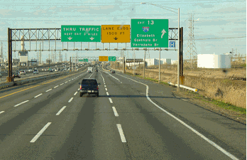
LEFT: This 2000 photo shows the westbound NJ 33 Freeway at Wemrock Road in Freehold Township. RIGHT: This 2000 photo shows the current eastern terminus of the NJ 33 Freeway at Halls Mill Road in Freehold Township. Note the construction barriers on the left side of the carriageway for the NJ 33 Freeway Extension. The extension opened to traffic in January 2003. (Photos by Raymond C. Martin.) |
||
|
SOURCES: Transportation 1985: A Regional Plan, Tri-State Transportation Commission (1966); New Jersey Highway Facts, New Jersey Department of Transportation (1967); "Route 33 Widening Delayed" by John A. Harnes, The Asbury Park Press (10/06/1999); "Freehold Bypass on Track for Completion in 2002" by Sherry Conohan, The Asbury Park Press (6/20/2000); "Road Halfway Done," The Asbury Park Press (8/22/2001); "Market-Based Solutions for Peak-Hour Congestion in the Trenton-New Brunswick Route 1 Corridor" by Meghan K. Fehlig, Princeton University (2002); North Jersey Transportation Planning Authority; Tri-State Transportation Campaign; Phil Case; Raymond C. Martin; Christopher G. Mason; Dan Moraseski; Al Tossoonian; William F. Yurasko. |
||
|
NJ 33 FREEWAY LINKS: |
||
|
CURRENT METRO COMMUTE ROAD CONDITIONS: |
||

|
OFF-SITE EXIT LISTINGS: |
||
|
VIEW OR SUBMIT YOUR RATING TO RATETHEROADS.COM: |
||

|
Back to The Roads of Metro New York home page. |
||
|
Site contents © by Eastern Roads. This is not an official site run by a government agency. Recommendations provided on this site are strictly those of the author and contributors, not of any government or corporate entity. |
||