 |
|
|
|
|
|
|
|
|
|
|
|
|
|
|
|
|
|
|
|
|
|
|
|
|
|
|
|
|
|
|
 |
|
|
|
|
|
|
|
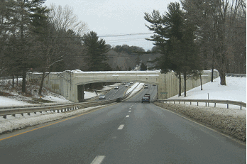
OLD ROUTE 31: Extending 54 miles through Mercer, Hunterdon and Warren counties in western New Jersey, NJ 31 was constructed in the 1920's. For about six miles between Ringoes and Flemington in Hunterdon County, NJ 31 is multiplexed with US 202, a divided four-lane arterial highway. Most of the remainder of NJ 31, however, is undivided country road. Indeed, most of the road dates back to the 1700's.
The inadequacies of NJ 31 have been apparent for many years. Limited sight distances, tight curves and steep grades have compromised safety. Many stretches of NJ 31 either have no shoulders, or shoulders that are less than six feet wide. Moreover, some sections were widened from two to four lanes by the elimination of shoulders.
The current NJ 31 received its current designation in 1969, before which time it had been designated NJ 69. More on the former NJ 69 designation from an e-mail sent by a contributor:
When I got my driver's license in 1960, it was already a rite of passage to steal a Route 69 sign, solely because of the sexual "69" position. I remember making a middle of the night trip to Route 69 with my girlfriend, who was to be my lookout while I unbolted the sign. So many signs had already been stolen, that on the back of each 69 sign was the stenciled warning, "HEAVY PENALTY FOR REMOVAL." This warning was not found on other routes! My tools were not up to the task, so I never did get a NJ 69 sign.
The sign stealing on Route 69 may well have peaked when the class of 1969 was in school, and was probably the straw that broke the back of the very-slow-to-learn NJDOT and led to the re-designation as Route 31.
THE UNBUILT NJ 31 FREEWAY: In the 1960's, the New Jersey Department of Transportation (NJDOT) and the Tri-State Transportation Commission recommended the construction of a four-lane freeway between US 1 (Trenton Freeway) in Trenton and US 202 in Ringoes. The new NJ 31, which had been NJ 69 until 1967, was to join a new US 202 Freeway at this location. The 10-mile-long NJ 31 Freeway, which was to be constructed on new right-of-way, was estimated to cost $18 million. It was scheduled for completion by 1975.
In its 1966 report, Transportation 1985: A Regional Plan, the Tri-State Transportation Commission states the purpose and benefits of the NJ 31 Freeway as follows:
This north-south route through Trenton and northern Mercer County will relieve traffic on an existing arterial. It will provide traffic service perpendicular to radial corridor routes such as US 1, I-95 and US 202.
Dan Moraseski, creator of "SPUI" web site, provided the following information on the route of the proposed NJ 31 Freeway:
The NJ 31 Freeway would have left existing NJ 31 at the circle with Mercer CR 546, then crossed I-95 just west of the never-built I-95 / I-295 split in Ewing Township. It would have had an interchange (northbound exit, "half-diamond") at Bull Run Road midway between existing NJ 31 and Federal City Road. After that, the proposed freeway would have crossed Ewingville (Parkside) Road twice, first near Federal City Road and again near Sherbrooke Road (where an interchange was to be constructed).
Moving southeast toward White Horse Township, the NJ 31 Freeway would have crossed US 206 (Princeton Avenue) near Mercer CR 645 (Brunswick Circle Extension), where a modified trumpet interchange would have been constructed. It would have continued along Mercer CR 645 and Strawberry Street toward US 1.
The NJ 31 Freeway would have ended at US 1, and continued south as a four-lane divided arterial across Whitehead Road (just northeast of Mercer CR 535). It would have continued along the eastern edge of Greenwood Cemetery to the intersection of Hamilton Avenue and Cypress Lane. From Cypress Lane, it would have continued to I-295, then curved southeast to cross Mercer CR 533 just south of Pond Run. The new NJ 31 arterial would have ended at EXIT 3 on I-195, at Hamilton Square Road.
Raymond C. Martin, developer of njfreeways.com, submitted the following additional information as follows:
In preparation for the construction of the NJ 31 Freeway, extensive rights-of-way were bought by NJDOT in a strip extending from Ewingville Road (Mercer CR 636) near Spruce Street (Mercer CR 613), continuing to the middle stretch of Green Lane, then north to cross Ewingville Road again just a few feet west of the intersection with Federal City Road, then north toward Bull Run Road.
The right-of-way parallels the Shabakunk Creek throughout most of its route, and also forms the back edge of The College of New Jersey (formerly Trenton State College). It is not unlikely that the NJ 31 Freeway would have been used as a "college road," with a separate exit only to The College of New Jersey (at least considering the political clout that the college seems to have in Ewing regarding property acquisition).
The remaining right-of-way is still evident today. Between Ewingville Road and Bull Run Road, developments built in the 1960's often have streets truncated near the edge of the right-of-way, perhaps either from street plans that the NJ 31 Freeway plans disrupted, or (in the case that NJ 31 Freeway was not constructed) that these streets could be extended into the right-of-way and developed. A fairly long stretch of the right-of-way near The College of New Jersey is currently used for utility wires.
During the last few years, efforts have been made to preserve the unbuilt NJ 31 right-of-way as open land, instead of opening it up to development. These plans are apparently going forward.
|
|
|
|
|
|
|
|
|
|
|
|
|
|
|
|
|
|
|
|
|
|
Toward the end of the 1960's, the NJDOT considered plans to extend the NJ 31 Freeway north toward I-78 (near Clinton) and I-80 (near Hope Township). To the southeast, the Delaware Valley Regional Planning Commission (DVPRC) planned a six-mile-long, $25 million extension from the US 1 Freeway to I-195 (just east of the I-295 interchange) in Trenton.
More ambitious plans developed by the NJDOT in the early 1970's showed a 36-mile-long, $80 million extension of the NJ 31 Freeway north of I-80 along the eastern boundary of the Delaware Water Gap National Recreation Area to the intersection of I-84 and the proposed NJ 23 Freeway near Port Jervis, New York. However, intense community opposition, new environmental restrictions and tight budgetary constraints, forced the NJDOT to drop plans for the NJ 31 Freeway in the mid-1970's.
|
|
|
|
|
|
|
|
|
|
|
|
|
|
|
|
|
|
Frank Curcio, New Jersey contributor to misc.transport.road and nycroads.com, provided some insight into the potential difficulties of constructing a new NJ 31 Freeway as follows:
In order to make NJ 31 a true freeway, it must be sandwiched between dual service roads with connecting overpasses. There is no space to construct the freeway and its service roads, and it is doubtful that there is either the money or the political will to construct the freeway.
Money is also the problem with buying a new right-of-way, since this is some of the most expensive real estate in the nation. I doubt that there is a groundswell of support around the nation to send more Federal money to help the NJDOT buy $700,000 houses to rip them down in order to build another highway.
As people clamor for improvements to NJ 31, improvements are made which attracts more traffic, including truck traffic that causes people to clamor for improvements on NJ 31. And so the cycle continues
More recent efforts have focused on bringing NJ 31 up to four-lane divided arterial status along some sections. The newly dualized sections have signalized intersections, and jughandles to minimize left-turns. To date, about six miles of NJ 31 has been upgraded to four-lane divided in the vicinity of I-78 in Clinton, and another two miles of the route is currently under construction. A four-lane divided bypass of NJ 31 is being planned from Clinton south to US 202 in Flemington.
THE TRUCK BAN ON NJ 31: Long after the NJ 31 Freeway proposal died, congestion has continued to build on the NJ 31 corridor, especially in Mercer and Hunterdon counties. The lack of viable north-south freeway and arterial alternatives in western New Jersey has forced long-distance traffic onto local roads.
While most cars use NJ 31 as a local route, many trucks use NJ 31 as a long-distance truck route, since it provides a toll-free, more direct route through western New Jersey. The mix of local-traffic cars and long-distance trucks, combined with the multiple driveways and lack of left-turn lanes, has created an unsafe mix.
On July 16, 1999, Governor Christine Whitman authorized an emergency ban on oversize trucks (those exceeding 53 feet in length and 102 inches in width) from highways not in the National Highway System. This ban prohibits long-distance trucks that are neither picking up nor delivering goods from routes not in the system, including NJ 31.
Citing an NJDOT study, spokesman John Dourgarian told The Star-Ledger that approximately 2,000 trucks drive on NJ 31 in Hunterdon County each day, and about 500 of them are simply passing through the state. Of these 500 trucks, about half of these trucks are 102 inches wide. These trucks now must use I-287 and the New Jersey Turnpike (I-95).
How would enforcement of the truck ban be carried out? When the ban was announced, David Greenberger posted the following on misc.transport.road:
It's easier to spot an oversized rig than an overweight rig, so enforcement is possible. I spoke with a New Jersey assemblyman, a former owner of a trucking company, about this issue.
Although favors the ban on NJ 31, he is mixed about the ban on US 206, a parallel route east of NJ 31. (There is no alternative to US 206 north of Somerville). He said the reason for the use of NJ 31 is time. Despite more congestion, a lower speed limit and the presence of traffic lights, NJ 31 cuts 15 minutes off the north-south trip in eastern Pennsylvania and west central New Jersey. He himself didn't believe this at first, so sent his rigs both ways and found this to be true.
According to this trucker-turned-assemblyman, a manifest with a local pick-up or drop-off allows the trucker on the road. He also said that it is time, more so than tolls or fines, which determines the routes of most truckers, especially those of the independent owner-operators.
So the enforcement is the pullover by the troopers. A pull-over could consume lots of time as the troopers check manifests and logs, longer if they decide to do a safety check or try to call the NJDOT to find an approved route for the trucker, and longer still if the troopers decide to escort the wayward truck to an approved truck route. This is a significant amount of time in today's "just-in-time" delivery market, more costly than a ticket, and a serious deterrent for the dollar-wise trucker.
FREEWAY REVIVAL? Recently, the NJDOT announced plans for a four-lane, controlled-access "Flemington Bypass" connecting US 202 in Flemington with the existing NJ 31. Beginning at US 202 just east of Greenwood Place, the three-mile-long Flemington Bypass would continue north past Flemington Junction Road (Hunterdon CR 523) and Sand Hill Road / Bartles Corner Road (Hunterdon CR 612), and rejoin the existing NJ 31 mainline just north of Byway Farm Lane. Grade-separated interchanges would be constructed at US 202, Hunterdon CR 523 and Hunterdon CR 612. The $115 million project is slated for completion in 2006.
The following projects would supplement the NJ 31 Freeway proposal:
The existing NJ 31 would be widened for a distance of 1.8 miles north of the northern terminus of the Flemington Bypass. The $29 million project, which is slated for completion in 2003, would widen NJ 31 from two lanes to four lanes.
The existing Flemington Circle, where NJ 31, US 202 and NJ 12 intersect, would be replaced by a grade-separated interchange. The $21 million project, which is slated for completion in 2005, would include reconstruction of the US 202 and NJ 31 mainline through the area.
|
|
|
|
|
|
|
|
|
 |
|
|
|
|
 |
|
|
|
|
|
With the growing through traffic volume along the NJ 31-US 206 corridor and the lack of a viable north-south route through western New Jersey, the NJ 31 Freeway proposal should be reconsidered as the "West Jersey Turnpike." To help expedite its construction, the 53-mile-long road should be constructed as a toll facility, since users (primarily out-of-state motorists) would then bear the true costs of the turnpike.
The West Jersey Turnpike would have a 450-foot-wide right-of-way, enough to create a corridor of open space around the facility. Built to Interstate-compatible standards, the turnpike would have six lanes (three in each direction), with a wide, variable median to accommodate a future lane in each direction. To minimize visual and noise intrusion, and to enhance the environment, care should be taken to preserve existing vegetation, and to create new landscaping features, along this corridor.
|
|
|
|
|
|
|
|
|
|
 |
 |
|
|
|
|
|
|
|
|
|
|
|
|
|
The proposed turnpike, which would have the NJ 31 designation, is designed to connect Interstate highways in the Trenton area with I-78 near Whitehouse Station, Hunterdon County, and with I-80 near Netcong, Morris County. However, given the history of opposition to new highways in the rural Hopewell Valley, the West Jersey Turnpike may never be built.
Chris Blaney, New Jersey contributor to nycroads.com and misc.transport.road, advocates construction of a new toll Interstate highway along the NJ 31-US 206 corridor. His proposal is as follows:
As I see it, the truck ban is a band-aid to cover up for a serious deficiency in high-speed truck routes and through-traffic bypasses in northwestern New Jersey. I recommend building two extensions to the Interstate system in New Jersey.
Initially, the four-lane freeway would utilize a 400-foot-wide right-of-way, with a later provision to convert the wide median for two additional 2-lane carriageways. Fully expanded, it would then be a 2-2-2-2 local-express configuration, with the outer roadway reserved for trucks, while the inner roadway would be reserved for passenger cars. The common Interstate-standard design criteria should apply.
The new freeway, which would begin as I-187, would start in Ewing Township, and continue north along the east side of NJ 31. At Ringoes, where a connector would be constructed to connect with the existing US 202 Freeway (which would be re-designated I-387) west to Pennsylvania, I-580 would cross US 202, and continue northeast along the north side of existing US 202-NJ 31. Near Bridgewater, I-187 would merge with I-287 north of EXIT 13 (US 202-US 206), where the I-187 designation would end. For approximately five miles, the new freeway would be multiplexed with the existing I-287 north to Bedminster.
Beginning near I-287 (EXIT 13, US 202-US 206) in Bedminster, the new freeway, which would carry the I-580 designation, would continue north through Somerset and Morris counties parallel to, and along the east side of US 206. It would terminate at I-80 near Netcong, between existing EXIT 27 (US 206) and EXIT 28 (NJ 10).
The exit numbering on I-187 (the southern section of the new freeway) would extend the I-295 exit numbering north to I-287 in Somerville. New exit numbers would be used on I-580 (the northern section of the new freeway) from Bedminster north to Netcong.
This route would alleviate most of the truck traffic from NJ 31, US 202, and US 206, as well as provide an important north-south expressway route where one is desperately needed. Any inner-roadway design could be built with electronic tolling. Truck licensing and registration fees would pay for the outer roadways, which would eventually be used by commercial vehicles.
|
|
|
|
|
|
|
|
|
|
|
|
|
|
|
|
|
|
|
|
 |
|
|
|
 |
|
|
|
|
|
SOURCES: Transportation 1985: A Regional Plan, Tri-State Transportation Commission (1966); New Jersey Highway Facts, New Jersey Department of Transportation (1967); 1985 Regional Transportation Plan, Delaware Valley Regional Planning Commission (1969); "Interstate 80-84 Links Opposed," The New York Times (11/27/1972); Master Plan for Transportation, New Jersey Department of Transportation (1972); "Truckers Carve a New Route, Crowding a Two-Lane Road" by Andy Newman, The New York Times (7/23/1995); "Traffic Woes May Jump Start Stalled I-95 Link" by David Newhouse, The Trenton Times (10/22/1995); "Missing Link To Be Revived?" by Ruth Luse, The Hopewell Valley News (10/26/1995); "NJ Bars Huge Rigs on Most Highways" by Matthew Futterman, The Star-Ledger (7/17/1999); Chris Blaney; Frank Curcio; Adam Froehlig; David J. Greenberger; Raymond C. Martin; Christopher G. Mason; Dan Moraseski; William F. Yurasko.
NJ 31 shield by Ralph Herman.
New Jersey Turnpike shield by New Jersey Turnpike Authority.
|
|
|
|
|
|
|
|
|
|
|
|
|
|
|
|
|
|
|
|
|
|
|
|
|
|
 |
|
|
|
|
|
|
|
|
|
|
|
|
|
|
Site contents © by Eastern Roads. This is not an official site run by a government agency. Recommendations provided on this site are strictly those of the author and contributors, not of any government or corporate entity.
|
|
|
|
|
|
|
|
|
|