 |
|
|
|
|
|
|
|
|
|
|
|
|
|
|
|
|
|
|
|
|
|
|
|
|
|
|
|
|
|
|
|
|
|
|
|
|
|
|
|
|
|
|
|
|
|
|
|
|
|
|
|
|
 |
|
 |
|
|
|
|
|
|
|
 |
|
|
|
|
|
PLANNED AS A PARKWAY: In 1932, the Regional Planning Federation (the predecessor agency to the Delaware Valley Regional Planning Commission) proposed a parkway system around the Philadelphia area similar to that constructed by Robert Moses. Borrowing from the Moses design conventions, the four-lane parkways were to feature controlled access, stone-arch bridges, timber lightposts and natural vegetation.
|
|
|
|
|
|
|
|
|
|
|
|
|
|
One such parkway was proposed along the eastern bank of the Delaware River. The proposed parkway was to extend from downtown Trenton north to Lambertville, along the current NJ 29 corridor.
A NEW WATERFRONT ROUTE FOR TRENTON: Conceived in the early 1950's as part of the "Trenton Complex," the 9.4-mile-long NJ 29 Freeway - originally called the East-West Highway, and later called the John Fitch Parkway - was designed to provide access to downtown Trenton from outlying suburbs to the east and west. It was to also provide controlled access between north-south radial routes that connect to New York and Philadelphia.
The initial section of the four-lane divided NJ 29, a 6.2-mile-long stretch running from South Warren Street in downtown Trenton north to I-95 (future I-295 extension) in Ewing Township, was constructed between 1954 and 1957. To build the freeway, the New Jersey State Highway Department acquired much of Stacy Park from the city of Trenton, leaving only a small strip of parkland along the Delaware River. The city has tore down its water works within the NJ 29 right-of-way, and replaced it with a new water filtration plant.
The original section of the NJ 29 Freeway through Trenton was constructed to then-contemporary standards. However, with its limited shoulders and short acceleration-deceleration lanes, this freeway no longer complies with current standards. Furthermore, cracks have begun to appear in the concrete roadway. While some speculate that work may begin on rehabilitating the roadway in the near future, the NJDOT has not made any official announcement on such a project.
LINKING TO THE "TRENTON COMPLEX" TO THE EAST: From 1990 to 1995, the NJDOT constructed the eastern section of NJ 29 Freeway. Extending from NJ 129 in Trenton south to the I-195 / I-295 interchange in Hamilton Township, this 1.8-mile-long section was constructed to more modern design standards, with four 12-foot-wide lanes, 12-foot-wide shoulders, a variable median and a 55 MPH speed limit.
|
|
|
|
|
|
|
|
|
|
|
|
|
|
 |
|
|
|
|
 |
|
 |
|
|
|
|
|
|
|
|
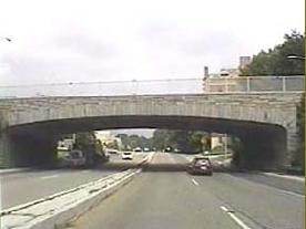
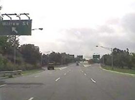
LEFT: This 2000 photo shows the northbound NJ 29 Freeway (John Fitch Parkway) at Calhoun Street in downtown Trenton. RIGHT: This 2000 photo shows the southbound NJ 29 Freeway (John Fitch Parkway) through Stacy Park in Trenton. The "Willow Street" exit signed here has been re-signed as "Memorial Drive." (Photos by Raymond C. Martin.)
|
|
|
|
|
|
|
|
|
|
|
|
|
|
|
|
 |
|
 |
|
|
|
|
|
COMPLETING THE MISSING FREEWAY LINK: In the late 1960's, the NJDOT and the Tri-State Transportation Commission recommended a $35 million plan to upgrade NJ 29. To the south, the NJDOT proposed the existing NJ 29 (which at the time went from downtown Trenton west to I-95) be extended for 3.2 miles east to the I-195 / I-295 interchange. To the north, the NJDOT proposed that the existing NJ 29 arterial highway constructed in the 1950's be upgraded to contemporary freeway standards. Together, the extensions were to extend the route of I-195 into Trenton. It is conceivable that the entire NJ 29 Freeway through Trenton may have been re-designated I-195.
|
|
|
|
|
|
|
|
|
|
|
|
|
|
|
|
|
|
Support for completing the NJ 29 Freeway continued, as demonstrated in the following statements from the New Jersey Department of Transportation (NJDOT) and the Tri-State Transportation Commission:
The NJ 29 Freeway, a north-south route along the Delaware River, will complete an existing expressway, provide relief to congested US 206, and provide a direct route between I-295 and downtown Trenton. At its southeastern terminus, it will connect with the NJ 37 Freeway (I-195), hence becoming a part of the Central Jersey Expressway. The NJ 29 Freeway will ultimately provide a badly needed artery for the free flow of north-south traffic to the state capital.
|
|
|
|
|
|
|
|
|
|
|
|
|
|
|
|
|
|
However, the NJDOT never completed the direct freeway link from downtown Trenton south to the I-195 / I-295 interchange in its entirety. The plan to improve NJ 29 north of downtown Trenton also met with less than enthusiastic reception.
THE NJ 29 (TUNNEL) PROJECT: For years, there existed a 1.4-mile-long gap between the older NJ 29 arterial highway to the west, and the newer NJ 29 freeway connection to the east. Motorists between the two sections used Lamberton Road, a two-lane residential street that is not officially designated as NJ 29.
In 1997, the NJDOT began construction of the NJ 29 "missing link" from the Amtrak-SEPTA railroad bridge east to the NJ 29 / NJ 129 junction. The new NJ 29 features four 12-foot-wide lanes (two lanes in each direction), full-width (12-foot-wide) right shoulders and a concrete ("Jersey") barrier to separate opposing traffic flows. The NJ 29 project was included as part of the 1998 "TEA-21" Federal transportation bill. However, the Federal government paid only $13 million of the $105 million cost; the remainder came from state funds.
Beginning at the end of the existing NJ 29 Freeway in downtown Trenton, the northbound and southbound roadways diverge between the Amtrak-SEPTA railroad bridge and Waterfront Park. In this area, a variable-width median separates the roadways. Two new traffic lights (at Cass Street) along NJ 29, which is an "urban principal arterial" through the area, serve Waterfront Park and a nearby corporate park.
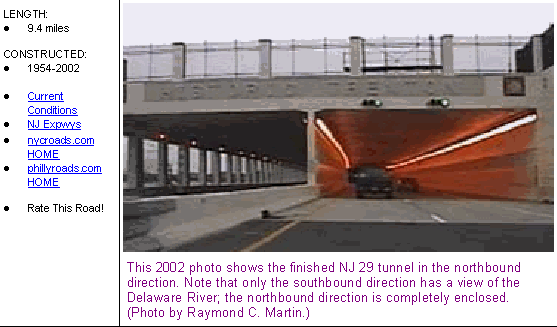
Continuing east of Waterfront Park, NJ 29 transitions to a depressed, controlled-access freeway configuration on its way to the tunnel section. The tunnel is not a bored tube, but a covered roadway section built over the banks of the Delaware River. The roadway has four 12-foot-wide lanes and full-width (12-foot) right shoulders. Only the southbound roadway has a view of the river; the northbound roadway is blocked by a retaining wall. Ramps were constructed to connect the tunnel to Lalor Street and Landing Street.
To accommodate the new NJ 29 Freeway and exit ramps, the NJDOT constructed a wall to separate the river from the tunnel. Once this part of the project is completed, crews dug down about 15 to 20 feet and removed the dirt, in order to lay the roadbed and cover for the tunnel. The NJDOT also constructed the existing Lamberton Road, which previously served as a route for through NJ 29 traffic, as a narrow low-volume residential street.
More on the NJ 29 tunnel from nycroads.com and phillyroads.com contributor Jeff Taylor:
An engineer from the NJDOT told me that at one point, the original plan was to have the tunnel three lanes wide each way with a full size shoulder, which would have extended the tunnel halfway into the Delaware River, and to have an interchange instead of traffic lights in front of the ballpark. Various groups were able to snap away at the project, and the final plans called for a tunnel, two lanes each way, and 12-foot-wide shoulders. The NJDOT tried explaining to no avail that this would create the need for additional construction about 20 years down the line, but the opposing groups didn't care.
|
|
|
|
|
|
|
|
|
|
|
|
|
|
 |
|
|
|
|
|
|
|
|
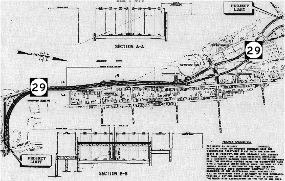
Schematic diagram of the NJ 29 construction project, which was completed in 2002. The new NJ 29 includes a new boulevard and tunnel along the banks of the Delaware River. North is oriented to the right of the map. (NJDOT project map supplied by Len Pundt.)
|
|
|
|
|
|
|
|
|
|
|
|
|
|
|
|
|
|
|
|
FURTHER DELAYS: Originally scheduled for completion by 2001, several delays plagued the NJ 29 tunnel project and delayed its completion date. In April 2000, the Army Corps of Engineers ordered a halt to all work on the project after the Corps discovered that the NJDOT violated clean water laws by dumping dredged material back into previously dredged river areas, rather than an approved upland disposal site. The Corps also found that an improperly installed silt box allowed contaminated soil to flow into the Delaware River; it took nine months to remove this soil. Finally, construction crews accidentally severed a sewer line, sending raw sewage flowing into basements along South Warren Street.
|
|
|
|
|
|
|
|
|
|
|
|
|
|
TUNNEL OPENS AMID CONTROVERSY: The last section of the tunnel roof was placed in October 2001. After preparing the pavement and electrical work for the tunnel and approach roadways, the NJDOT opened the missing link of NJ 29 on March 2, 2002. Since the tunnel is the first operated by the NJDOT, the agency sought the assistance of the Port Authority of New York and New Jersey on tunnel operations.
The tunnel and highway complex, which has a speed limit of 45 MPH (it opened with a speed limit of 35 MPH), is expected to handle approximately 40,000 vehicles per day (AADT). Originally, the NJDOT planned to ban the transport of hazardous materials through the tunnel. However, before the tunnel opened, the NJDOT announced that all trucks exceeding a 13-ton weight limit would be prohibited from using it, drawing the indignation of officials who thought that the new NJ 29 would get trucks off congested local streets. The truck restriction was made permanent in November 2002.
COMPLETE WITH A RIVERFRONT PARK: In conjunction with the engineering consulting firm Vollmer Associates, the NJDOT built a $15 million, 6.5-acre park atop the deck of the NJ 29 tunnel. Completed in 2003, the park features trees, landscaping and an interpretive area highlighting the history of the South Trenton waterfront. In a separate project, a new bike path and pedestrian walkway was built to connect Riverfront Stadium with the new linear waterfront park. There also was a new urban streetscape plan for the eastern side of adjacent Lamberton Street.
|
|
|
|
|
|
|
|
|
|
|
|
|
|
 |
|
 |
|
|
|
|
|
|
|
|
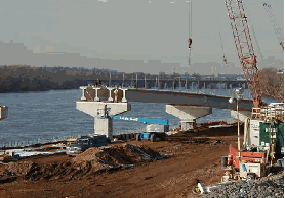
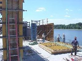
LEFT: This 2000 photo shows the construction of the ramp connecting NJ 29 to Lalor Street. RIGHT: This 2001 photo shows construction of the NJ 29 tunnel section nearing completion. (Photos by New Jersey Department of Transportation.)
|
|
|
|
|
|
|
|
|
 |
|
|
|
|
|
|
|
|
|
|
 |
|
|
|
 |
|
|
|
|
|
SOURCES: Regional Plan of the Philadelphia Tri-State District, Regional Planning Federation (1932); "Report on Route 29 Connection," New Jersey State Highway Department (1960); Regional Highways: Status Report, Tri-State Transportation Commission (1962); Transportation 1985: A Regional Plan, Tri-State Transportation Commission (1966); New Jersey Highway Facts, New Jersey Department of Transportation (1967); 1985 Regional Transportation Plan, Delaware Valley Regional Planning Commission (1969); "Interstate Routes 195 and 295, New Jersey Routes 29 and 129: Administrative Action Final Environmental Impact Statement and Section 4(f) Statement," Federal Highway Administration and New Jersey Department of Transportation (1981); "Trenton: 1957: Forecasts of Boom and Doom" by Paul Mickle, The Trentonian (1999); "Route 29 Work Halt Ordered" by Tom Hester, Jr., The Trenton Times (4/06/2000); "Tunnel, Beltway Getting Final Touches" by Michael Jennings, The Trenton Times (12/28/2001); "Route 29 Construction," New Jersey Department of Transportation (2001); "DOT Extravagance," The Star-Ledger (1/15/2002); "Tunnel To Debut" by Albert Raboteau, The Trenton Times (2/27/2002); Vollmer Associates; Phil Case; Raymond C. Martin; Christopher G. Mason; Dan Moraseski; Len Pundt; Jeff Taylor.
NJ 29 and I-195 shields by Ralph Herman.
Lightposts by Millerbernd Manufacturing Company.
|
|
|
|
|
|
|
|
|
|
|
|
|
|
|
|
|
|
|
|
|
|
|
|
|
|
 |
|
|
|
|
|
|
|
|
|
 |
|
|
|
|
|
|
|
|
|
 |
|
|
|
|
|
VIEW OR SUBMIT YOUR RATING TO RATETHEROADS.COM:
NJ 29 Freeway
|
|
|
|
|
|
|
|
|
|
|
|
 |
|
|
|
|
|
|
|
|
|
|
 |
|
|
|
|
|
|
|
|
|
|
 |
|
|
|
|
|
|
|
|
|
|
|
|
|
|
Site contents © by Eastern Roads. This is not an official site run by a government agency. Recommendations provided on this site are strictly those of the author and contributors, not of any government or corporate entity.
|
|
|
|
|
|
|
|
|
|