EARLY PLANS FOR A TRENTON BELTWAY: During the 1940's and early 1950's, state highway officials proposed a beltway around the northern half of Trenton. Beginning at the vicinity of the now-dismantled Yardley Bridge (about 1.3 miles south of the Scudder Falls Bridge), where a new Delaware River crossing was to be built, the NJ 39 beltway (as it was to be designated) was to run in a semi-circular path through Trenton's northern and eastern suburbs, though it was to be built closer to Trenton than the current I-95 / I-295 route. Plans for the beltway were shelved eventually in favor of the current Interstate highway routing.
WHICH ALIGNMENT SHOULD I-95 TAKE THROUGH TRENTON? When the Federal-aid Interstate Highway System was being developed in the mid-1950's, the New Jersey State Highway Department proposed a north-south, controlled-access highway to serve medium- and long-distance traffic. The new alignment, which was to parallel US 1 and the New Jersey Turnpike, would eventually become I-95.
While this alignment was compatible with the Interstate system objective of connecting major metropolitan and industrial areas, the Federal Bureau of Public Roads (BPR) was concerned that this proposed alignment would serve the same corridor as the New Jersey Turnpike. Nevertheless, after extensive study and discussion between the involved agencies, the BPR approved the general alignment from Ewing Township northward in 1957. However, the BPR withheld approval of the proposed alignment from Ewing Township south to the Delaware River, pending coordination of an acceptable routing with the Pennsylvania Department of Highways.
Pennsylvania initially sought to route I-95 across the Delaware River along the Trenton Toll Bridge, then north through Trenton along the Trenton Freeway. New Jersey, however, opposed this routing on the basis of the physical and capacity constraints on the four-lane bridge and freeway. The two states jointly investigated three alternative river crossings: Scudder Falls (west of Trenton), existing Trenton Toll Bridge-Trenton Freeway (through downtown), and Biles Island (east of Trenton). After further study, the two states approved the Scudder Falls alignment in 1960.
Although the Scudder Falls and Trenton Toll Bridge-Trenton Freeway were of similar length, the Scudder Falls alignment was found to provide superior traffic service, since the existing alignment through downtown Trenton was operating at capacity. Between the Delaware River and Ewing Township, I-95 was to be routed along the proposed NJ 129 Freeway. Together with the proposed I-295, I-95 was to form part of a circumferential highway around Trenton. Direct service to Trenton was to be provided by the east-west NJ 29 Freeway.
CONSTRUCTION OF TRENTON'S I-95: In 1959, the Delaware River Joint Toll Bridge Commission (DRJTBC) constructed a new toll-supported bridge between Ewing Township, New Jersey and Lower Makefield Township, Pennsylvania. The 1,740-foot-long, ten-span bridge, which carries four lanes of traffic across the Delaware River, was completed in 1959. However, the bridge did not open until two years later, when the DRJTBC constructed temporary approaches on both sides of the span.
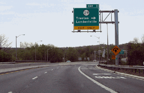
When construction of the Trenton section of I-95 began in 1961, it was designated as the NJ 129 Freeway. Beginning as four lanes at the Scudder Falls Bridge, the expressway widens to six lanes at EXIT 1 (NJ 29). This section, which extends east to EXIT 3 (Scotch Road), was completed in 1964. By that time, this section of expressway had been re-designated I-95.
By 1974, I-95 was extended north to milepost 5 (just north of EXIT 4-NJ 31) in Ewing Township, where a "ghost" interchange with unbuilt ramps was created. The unbuilt ramps were to extend to the Somerset Freeway (I-95), a 29-mile-long freeway that was to extend north to I-287 in Piscataway. This controversial freeway was canceled in the early 1980's.
The entire length of Trenton's I-95, which appeared in some planning maps as the "Delaware Expressway," was constructed to Interstate standards. Originally built with four lanes, the expressway was widened to six lanes in the early 1990's. The entire length of the expressway features 12-foot-wide shoulders and variable medians.
I-95 TO BECOME PART OF I-195: In 1995, the Trenton section of I-95 was extended from the unbuilt Somerset Freeway interchange north to US 1, where it meets I-295. (Previously, this stretch was part of I-295.) However, this re-designation will not be permanent. Once the $553 million I-95 / I-276 direct interchange project is completed in 2012, the I-95 shields along the 8.8 miles around Trenton will be replaced with I-195 shields. The I-195 designation will continue into Pennsylvania along the Delaware Expressway, where it will terminate at the I-95 / I-276 interchange in Levittown, Bucks County. This section was slated to become part of an extended I-295, but a September 2005 agreement between Pennsylvania and New Jersey established the new designation of I-195 for the orphaned I-95 section. The re-designation awaits approval from the American Association of State Highway and Transportation Officials (AASHTO).
IMPROVEMENTS TO I-95 THROUGH MERCER COUNTY: During the early 2000's, the NJDOT completed the following projects for the short section of I-95 around the Trenton area:
During 2001 and 2002, the NJDOT made improvements at EXIT 4 (NJ 31) in Hopewell Township. In November 2001, the existing EXIT 4A ramp from northbound I-95 to southbound NJ 31 was rebuilt to permit movements to northbound NJ 31, and the existing EXIT 4B loop ramp to northbound NJ 31 was closed. In 2002, a new ramp from northbound NJ 31 to northbound I-95 (to better accommodate trucks) was built at the site of the former loop ramp.
The NJDOT rebuilt EXIT 3 (Scotch Road) in Hopewell Township. In addition to completing the missing cloverleaf movements, the NJDOT plans to add collector-distributor (C/D) roads to separate local and express traffic at the interchange. The $20 million project is was completed in 2003.
In December 2001, the NJDOT implemented a 65 MPH speed limit along the length of the existing I-95 (future I-195) around Trenton.
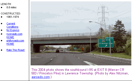
This 2004 photo shows the southbound I-95 at EXIT 1 (NJ 29) in Ewing Township, just before the Scudder Falls Bridge. (Photo by Alex Nitzman, aaroads.com.)
EARLY PLANS FOR THE CORRIDOR (1936-1955): The need to relieve congestion on US 1, particularly on the 90 miles between New York City and Philadelphia, had been apparent as early as the 1930's. At that time, officials from several Northeast states developed plans for a 12-lane Boston-to-Washington superhighway. Preliminary sketches showed a road with six carriageways, each carrying two lanes for express, local and service (frontage) traffic. Moreover, the Regional Plan Association recommended the construction of an expressway from New York south to Trenton and Philadelphia along the US 1 corridor. Despite the acute congestion on existing roads, the restricted budgets of the Great Depression and the outbreak of World War II delayed the superhighway.
In 1947, the New Jersey State Highway Department drafted plans to develop a new US 1 superhighway under the proposed National System of Interstate Highways. Initially, the Somerset Freeway - what would eventually become the I-95 corridor - was to be located parallel and to the east of existing US 1 from Trenton north to Woodbridge.
The possibility of improving US 1 was evaluated early in the process as a means of providing additional capacity and a high level of traffic service in central New Jersey. However, the analysis indicated that because of reconstruction and relocation costs associated with the required modifications, the upgrading of the existing US 1 corridor was not practical as a permanent solution for improved traffic mobility.
As these early plans were being developed, a new superhighway was taking shape parallel to the US 1 (and proposed I-95) corridor. From 1950 to 1952, the 118-mile-long New Jersey Turnpike was constructed, providing four lanes of controlled-access superhighway between the George Washington Bridge and the Delaware Memorial Bridge. It was connected to other turnpikes in the 1950's, and in the process, the "eastern turnpike complex" was formed.
DECIDING UPON AN ALIGNMENT (1956-1965): State highway officials in New Jersey then focused on a proposed limited-access highway to serve medium- and long-distance traffic in this corridor. Through central New Jersey, the alignment of the proposed highway was to be "generally parallel to, and one to two miles east of US 1." The New Jersey State Highway Department designated this alignment, which began at the Delaware River near Trenton and ended at I-80 in Teterboro, as FAI Route 103 (the precursor to I-95).
Concerns arose that the proposed alignment would duplicate the existing New Jersey Turnpike, which opened in its entirety in 1952. After extensive study and discussion between the BPR and state highway officials in New Jersey and Pennsylvania, the BPR approved the general I-95 alignment north of Ewing Township in 1957. However, the BPR withheld approval of the proposed alignment from Ewing Township south to the Delaware River, pending coordination of an acceptable routing with the Pennsylvania Department of Highways.
In 1960, after three years of traffic and engineering studies, the states of New Jersey and Pennsylvania approved a more westerly alignment near Scudder Falls. Still, the BPR maintained its position of disapproval of the Scudder Falls alignment, and requested further justification. During this process, the New Jersey State Highway Department performed additional traffic studies in the area north of Trenton. These studies indicated the following:
As a toll facility, the New Jersey Turnpike was incompatible with the original concept of the Interstate highway system.
The New Jersey Turnpike was outside the area of traffic generated in the expanding western portion of the New York-New Jersey-Philadelphia corridor.
Since traffic was already served by adequate routes in the southeast portion of the New York-New Jersey-Philadelphia corridor, it would be beneficial to provide additional capacity along the northwest fringe, and avoid the concentration of traffic within one travel corridor.
Engineering feasibility studies for various alternatives to locate I-95 west of US 1 confirmed that the proposed route would provide optimal service long-distance and medium-distance interstate traffic. Additionally, the proposed I-95 would provide service for intrastate and local service traffic.
In March 1964, the BPR finally approved New Jersey's I-95 alignment from the Scudder Falls Bridge north to I-287 in Piscataway, but denied approval for a new I-95 alignment from I-287 north to I-80. Instead, the BPR-approved alignment took I-95 east along I-287 to the New Jersey Turnpike, and then north along the turnpike to the George Washington Bridge.
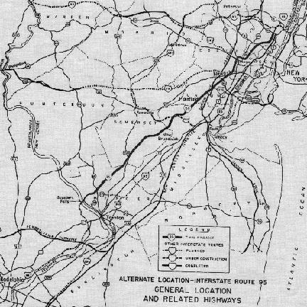
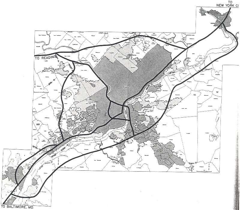
Alternative plans for Interstate 95 through New Jersey:
The dotted line for I-95 north of Ewing Township shows the alignment approved by the Bureau of Public Roads (BPR) in 1957. The I-95 alignment south of Ewing Township and the I-295 alignment were decided in 1960. The solid line showing the revised I-95 alignment was proposed by the New Jersey State Highway Department in 1962. The alignment from Trenton north to I-287 was approved in 1964 by the BPR. The I-95 "free alignment" from I-287 north to US 46 was rescinded.
(Map from "Alternative Route Study: Interstate Route 95," New Jersey State Highway Department, 1962.)
FINAL PLANS FOR THE CORRIDOR (1966-1979): In 1966, the Tri-State Transportation Commission, the Delaware Valley Regional Planning Commission, and the state highway departments of New Jersey and Pennsylvania conducted corridor location and engineering studies for Interstate 95 (also unofficially referred as the "Somerset Freeway" and the "Delaware-Raritan Freeway") between Ewing Township and Piscataway. In the studies conducted by engineering firm Parsons Brinckerhoff, the planning and highway officials summarized their findings as follows:
Interstate 95 will provide a missing link in an Interstate route that extends 1,857 miles from Maine to Florida. This route, which will serve northeast-southwest traffic movement within and throughout New Jersey, will provide for a safe, efficient movement of traffic that is presently traveling on indirect, congested and unsafe routes. When used in conjunction with I-287, it will allow traffic bound for upstate New York and New England to bypass the New York-northeast New Jersey metropolitan area. I-95 is consistent with regional and county plans.
The 29-mile-long section between Ewing Township and Piscataway was to be constructed to Interstate standards, with 12-foot-wide lanes, 12-foot-wide shoulders, a 60-foot-wide median and a 300-foot-wide right-of-way. Its six lanes were designed to handle 80,000 vehicles per day (AADT), with adequate median space available for an additional lane in each direction. The route, much of which was to parallel the Reading Railroad line, was to displace 40 homes and four businesses.
Beginning at milepost 5 on the existing I-95 in Ewing Township, and ending at I-287 near the Raritan River in Piscataway, interchanges were to be constructed at the following locations:
EXIT 5: I-295 SOUTH in Ewing Township (southbound exit only) EXIT 6: Mercer CR 546 (Lawrenceville-Pennington Road) in Hopewell Township EXIT 10: Mercer CR 569 (Hopewell-Princeton Road) in Hopewell Township EXIT 13: Somerset CR 518 (Georgetown-Franklin Turnpike) in Rocky Hill EXIT 19: US 206 in Montgomery Township EXIT 21: Somerset CR 514 (Amwell Road) in Hillsborough Township EXIT 23: Somerset CR 533 (Millstone River Road) in Franklin Township EXIT 28: I-695 NORTH to I-287 NORTH in Franklin Township (northbound exit only) JUNCTION: I-287 SOUTH to I-95 NORTH in Piscataway (northbound exit only)
Construction of the Mercer-Somerset section of I-95 was estimated to cost $55 million in 1967, an amount that had skyrocketed to $375 million by 1979.
The Tri-State Transportation Commission and the New Jersey Department of Transportation (NJDOT) also urged construction of a 3.4-mile-long, four-lane spur connection between I-95 in Manville Township and I-287 in Somerville to serve northwest-to-southwest traffic. The I-695 spur, known unofficially as the Somerset Freeway Extension, was approved by the BPR in October 1968.
In 1979, the NJDOT issued a final environmental impact statement for the missing links of I-95 and I-695, recommending their construction to relieve congestion on local roads and to provide Interstate service. That year, both the Tri-State Regional Planning Commission and the Delaware Valley Regional Planning Commission recommended construction of the two routes, but found that they would be most effective for local and medium-distance traffic. Long-distance Interstate traffic along the Northeast corridor would continue to be served by the New Jersey Turnpike.
THE END OF THE ROAD (1979-1982): By the late 1970's, the battle for I-95 was increasingly becoming a lost cause. Opposition came initially from the affected towns of Hopewell, Montgomery, and Princeton. The Middlesex-Somerset-Mercer Regional Study Council followed by issuing a statement against construction of I-95 through the area. Next, a bipartisan group of state legislators, led by state senators Anne Martindell of Princeton and William Schluter of Pennington, backed a measure to cut off funding for future studies, after a 1979 study found that congestion would increase on US 206 and NJ 31 from new office and housing complexes along the new I-95 corridor. The mounting opposition forced Governor Brendan Byrne, who initially sided with Federal and state highway officials to build I-95, to switch sides on the issue.
The fatal blow came in May 1980 when the NJDOT reversed its 1979 opinion, pulling its support for I-95 and submitting the de-designation for the route. The Federal Highway Administration (FHWA) approved both the 29-mile-long I-95 through central New Jersey, and the three-mile-long I-695 spur, for de-designation in January 1981. Finally, in December 1982, a bipartisan effort by U.S. Senators Nicholas Brady and Bill Bradley killed the missing link. The $375 million in funds for the Interstate trade-in were disbursed through the FHWA and the Urban Mass Transportation Administration (UTMA).
Predictably, the decision to kill the Somerset Freeway was hailed by the more affluent towns in the Hopewell Valley, whose residents believed that it would have destroyed their rural ambience. Further north, developers and business leaders criticized the move to kill I-95, believing that the move would discourage jobs and development.
When the NJDOT pulled its support from I-95 in 1980, The New York Times reported the following:
Killing I-95 means that the entire length of the turnpike almost surely will become the official I-95 artery through the state, thus assuring it a continued source of toll revenue. At present, only that segment of the turnpike north of EXIT 10 in Middlesex County is designated as I-95.
WILL I-95 BE RESURRECTED THROUGH CENTRAL JERSEY? (1983-2002): In 1983, the NJDOT suggested construction of a truncated Somerset Freeway from I-287 in Piscataway south to US 206 in Montgomery Township. The ten-mile-long freeway, which was to be paid for in part by $245 million in Interstate trade-in funds, never moved beyond the planning stages. In 1987, the NJDOT agreed to look at the unbuilt I-95 once again (upon the suggestion of Mercer County officials), but ultimately upheld the de-designation and proceeded with plans for the alternate projects.
Meanwhile, in the more than two decades since I-95 was canceled, the lack of viable north-south freeway alternatives, particularly those connecting to routes (such as I-78 and I-80) leading to western New Jersey), has forced long-distance traffic from the congested New Jersey Turnpike (now I-95) and US 1 onto local roads. Many trucks use local routes such as US 206 and NJ 31 as long-distance truck routes, since they provide toll-free, more direct routes through western New Jersey. The mix of local-traffic cars and long-distance trucks, combined with the multiple driveways and lack of left-turn lanes, has created an unsafe mix. The completion of the I-287 beltway in 1994 also provided long-distance motorists with an alternative to the clogged I-95 through New York City.
In 1995, officials in the Hopewell Township and Princeton areas discussed the possibility of reviving the Somerset Freeway between the existing I-95 in Ewing Township and I-287 in Piscataway. The project, which is expected to cost more than $700 million, would face years of public meetings, environmental review and funding challenges. The proposed freeway was presented as a means of relieving traffic on US 206, NJ 31 and other local roads.
Marvin Reed, the mayor of Princeton Borough, rationalized the need for the Somerset Freeway as follows:
Without the completion of I-95, central New Jersey is going to be choked. We can't have everybody telling us it's impossible. We think Senator Frank Lautenberg would agree that, as a designated regional center under the state plan, Princeton should not be burdened with trucks in the center of town. It's not good trucking policy, and anybody from far away would find it much easier to follow I-95 without having to wiggle their way through.
Worsening congestion on local roads has since prompted emergency restrictions. In July 1999, Governor Christine Whitman authorized an emergency ban on oversize trucks (those exceeding 53 feet in length and 102 inches in width) from highways not in the National Highway System. This ban prohibits long-distance trucks that are neither picking up nor delivering goods from routes not in the system, including US 206 and NJ 31. Northbound long-distance trucks are required to use the New Jersey Turnpike (I-95) and US 1, which both run southwest-to-northeast, to reach I-287 and western New Jersey points.
THE VEXING I-95 PROBLEM CONTINUES: The missing link of I-95 through New Jersey continues to be one of the most talked about topics in the misc.transport.road newsgroup. Arthur Malkin, New Jersey contributor to nycroads.com, provides some perspective:
Everyone talks about the vexing I-95 problem. Many people talk about the lack of a direct route between New York City and Philadelphia. But here's a different perspective on the problem you might not have considered:
The proposed I-276 / I-95 interchange in Pennsylvania, along with the rerouting of I-95 from that intersection, will not be an adequate replacement for the missing original I-95. Here's why: if you are trying to get to Trenton from New York City or Newark, just take the Turnpike and I-195. You can even take I-195 to I-295 for a freeway route to Philly. But what if you are coming from Morristown on I-287, and want to get to Trenton? Without the original I-95, you can only do the following:
From the Somerville Circle, you can take the most direct route, US 206, a dangerous two-lane road with scary traffic circles.
From the Somerville Circle, you can take US 202, which is at least a four-lane divided highway. It is great route for a weekend excursion to Flemington or New Hope, Pennsylvania. However, if you want to get to Trenton, you have to get off 202 near Lambertville and take NJ 31, another dangerous two-lane (and in some places, four-lane) road.
You can go really out of your way by staying I-287 to the New Jersey Turnpike, or (even worse) US 1. Talk about doubling back!
The point of the original I-95 was to let you continue your trip on I-287 south, straight to Trenton and Philadelphia, without having to go all the way east to the New Jersey Turnpike. If you are trying to get to Trenton or Philadelphia, just don't start from where I live in Morristown. You can't get there from here!
In 1997, the I-95 designation was extended south along the New Jersey Turnpike to EXIT 6 (Pennsylvania Turnpike). This designation was done in preparation for the new I-95 / I-276 interchange to be constructed near Levittown, Pennsylvania. From Levittown north to Trenton (via the Scudders Falls alignment), the existing I-95 will be re-designated I-295. Design, construction and completion dates for the interchange have not been officially announced.
EXIT NUMBERING ON I-95 IN NEW JERSEY: Chris Blaney, New Jersey contributor to nycroads.com, speculates on the I-95 exit numbering scheme in New Jersey:
There has been considerable debate as to whether the exit numbers on the other free I-95 section completed in New Jersey (between the New Jersey Turnpike EXIT 18 and the George Washington Bridge) reflect the exit numbers on I-80 (even though I-80 was never multiplexed on this route), or those on I-95 had the Somerset Freeway been completed. I stand firmly in the latter camp.
Recently, I made a little excursion up the eastern spur of the New Jersey Turnpike from EXIT 13A to EXIT 18.. I note that there really is no "EXIT 18"; that's just the number assigned to the northernmost toll plaza just north of EXIT 16E. The next numbered exit up is for US 46, the former northern terminus of the NJ Turnpike. It's signed as EXITS 68 A-B, but this number assignment comes over a mile before the I-80 junction!
With the growing through traffic volume along the US 206-NJ 31 corridor and the lack of a viable north-south route through western New Jersey, a new facility (the "West Jersey Turnpike") should be constructed to handle medium-to-long distance Interstate traffic. To help expedite its construction, the 53-mile-long road should be constructed as a toll facility, since users (primarily out-of-state motorists) would then bear the true costs of the turnpike.
The West Jersey Turnpike would have a 450-foot-wide right-of-way, enough to create a corridor of open space around the facility. Built to Interstate-compatible standards, the turnpike would have six lanes (three in each direction), with a wide, variable median to accommodate a future lane in each direction. To minimize visual and noise intrusion, and to enhance the environment, care should be taken to preserve existing vegetation, and to create new landscaping features, along this corridor.
The turnpike, which would have the NJ 31 designation, would be proposed to connect Interstate highways in the Trenton area with I-78 near Whitehouse Station, Hunterdon County, and with I-80 near Netcong, Morris County. However, given the history of opposition to new highways in the rural Hopewell Valley, the West Jersey Turnpike may never be built.
Chris Blaney, New Jersey contributor to misc.transport.road and nycroads.com, also advocates construction of a new Interstate highway along the US 206-NJ 31 corridor. His proposal is as follows:
As I see it, the truck ban is a band-aid to cover up for a serious deficiency in high-speed truck routes and through-traffic bypasses in northwestern New Jersey. I recommend building two extensions to the Interstate system in New Jersey.
Initially, the four-lane freeway would utilize a 400-foot-wide right-of-way, with a later provision to convert the wide median for two additional 2-lane carriageways. Fully expanded, then, it would be a 2-2-2-2 local-express configuration, the outer roadway being for trucks only, the inner roadway being for cars only. The common Interstate-standard design criteria should apply.
The new freeway, which would begin as I-187, would start in Ewing Township, and continue north along the east side of NJ 31. At Ringoes, where a connector would be constructed to connect with the existing US 202 Freeway (which would be re-designated I-387) west to Pennsylvania, I-580 would cross US 202, and continue northeast along the north side of existing US 202-NJ 31. Near Bridgewater, I-187 would merge with I-287 north of EXIT 13 (US 202-US 206), where the I-187 designation would end. For approximately five miles, the new freeway would be multiplexed with the existing I-287 north to Bedminster.
Beginning near I-287 (EXIT 13, US 202-US 206) in Bedminster, the new freeway, which would carry the I-580 designation, would continue north through Somerset and Morris counties parallel to, and along the east side of US 206. It would terminate at I-80 near Netcong, between existing EXIT 27 (US 206) and EXIT 28 (NJ 10).
The exit numbering on I-187 (the southern section of the new freeway) would extend the I-295 exit numbering north to I-287 in Somerville. New exit numbers would be used on I-580 (the northern section of the new freeway) from Bedminster north to Netcong.
This route would alleviate most of the truck traffic from NJ 31, US 202, and US 206, as well as provide an important north-south expressway route where one is desperately needed. Any inner-roadway design could be built with electronic tolling. The outer roadways, which would eventually be for trucks, would be paid for by truck licensing and registration fees.
SOURCES: "Freeways Are Now Urged," The New York Times (12/13/1936); "Alternative Route Study: Interstate Route 95," New Jersey State Highway Department (1962); Regional Highways: Status Report, Tri-State Transportation Commission (1962); Transportation 1985: A Regional Plan, Tri-State Transportation Commission (1966); New Jersey Highway Facts, New Jersey Department of Transportation (1967); "Interstates 95 and 695: Administrative Action Draft Environmental Impact Statement and Section 4(f) Statement," Federal Highway Administration and New Jersey Department of Transportation (1979); "Interstate 95," Delaware Valley Regional Planning Commission (1979); "I-95 Corridor in the Tri-State Region," Tri-State Regional Planning Commission (1979); "Governor Byrne Cancels I-95 Through Central Jersey," The New York Times (5/04/1980); New Jersey Transportation Plan, New Jersey Department of Transportation (1981); "Traffic Jams Around Princeton Rekindle a Highway Debate" by Jon Nordheimer, The New York Times (2/12/1995); "Towns Along Route 31 Fought an Interstate Link," The New York Times (8/20/1995); "Traffic Woes May Jump Start Stalled I-95 Link" by David Newhouse, The Trenton Times (10/22/1995); "Missing Link To Be Revived?" by Ruth Luse, The Hopewell Valley News (10/26/1995); "Three Counties Are Rethinking Missing Piece of Route 95 Puzzle" by Joe Tyrrell, The Star-Ledger (12/08/1996); "Ewing in Line for $4.5 Million Interchange" by Nick Manetto, The Trenton Times (3/11/1999); "NJ Bars Huge Rigs on Most Highways" by Matthew Futterman, The Star-Ledger (7/17/1999); "Pennsylvania Turnpike / I-95 Interchange Project," KCI Technologies (October 1999); "Evolving Pennsylvania Plan Would Uncover I-95's Missing Link" by Tom Hester, Jr., The Trenton Times (6/03/2002); "Market-Based Solutions for Peak-Hour Congestion in the Trenton-New Brunswick Route 1 Corridor" by Meghan K. Fehlig, Princeton University (2002); Delaware River Joint Toll Bridge Commission; New Jersey Department of Transportation; Chris Blaney; Frank Curcio; Adam Froehlig; Ralph Herman; Michael G. Koerner; George Kowal; Arthur Malkin; Raymond C. Martin; Christopher G. Mason; Dan Moraseski; Scott Oglesby; Len Pundt; Jack Watro; William F. Yurasko.
I-95, I-195, I-695, US 1, and NJ 31 shields by Ralph Herman. New Jersey Turnpike shield by New Jersey Turnpike Authority. Lightpost by Millerbernd Manufacturing Company.


