 |
|
|
|
|
|
|
|
|
|
|
|
|
|
|
|
|
|
|
|
|
|
|
|
|
|
|
|
|
|
|
|
|
|
|
|
|
|
|
|
|
|
|
|
|
|
|
|
|
|
|
|
|
|
|
|
|
|
|
|
|
|
|
|
|
|
|
|
|
|
|
|
|
|
|
 |
|
|
|
|
 |
|
 |
|
|
|
|
|
|
|
|
|
|
|
|
|
|
|
|
 |
|
|
|
|
|
|
|
 |
|
|
|
|
|
|
|
|
|
|
|
|
|
|
|
|
|
|
|
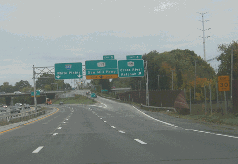
This 2005 photo shows the southbound I-684 at EXIT 6 (NY 35) in Katonah. The Saw Mill River Parkway begins just ahead at EXIT 5. (Photo by Steve Anderson.)
|
|
|
|
|
|
|
|
|
 |
|
|
|
|
 |
|
|
|
|
|
|
|
|
|
28.4 miles (45.7 kilometers); mainline
1.1 miles (1.8 kilometers); NY Route 984J spur to Hutchinson River Parkway
|
|
|
|
|
|
|
|
|
|
|
|
|
|
|
|
|
|
|
|
|
|
Interstate 684, the primary limited-access highway through eastern Westchester County, has an interesting story behind it. Unlike other area highways, I-684 is known officially by its number, not by its name. Originally, this expressway was to have been part of I-87.
THE NEW YORK-HARTFORD EXPRESSWAY: In 1936, the Regional Plan Association (RPA) recommended the construction of a network of expressways that were to supplement existing parkways in the New York metropolitan area. Unlike the existing parkways, the expressways were to be open to all traffic. One of the recommended routes was to extend north from the Bronx into eastern Westchester County, and then turn northeast toward Hartford. This expressway was to supplement the existing NY 22 and US 6. The onset of World War II delayed further study on this route.
|
|
|
|
|
|
|
|
|
|
|
|
|
|
|
|
|
THE EASTERN CORRIDOR EXPRESSWAY: In 1956, the Westchester County Planning Department recommended a realignment of NY 22 that would convert the north-south road into an expressway. The Eastern Corridor Expressway was designated as a high priority corridor by the county.
|
|
|
|
|
|
|
 |
|
|
|
|
|
|
|
|
|
|
From the recommendation report:
The purpose of this route is to improve NY 22 as a major north-south artery for mixed traffic, linking the rapidly developing areas in the northeastern part of the county with the White Plains and Port Chester-Rye areas, to facilitate the movement of through trucking and summer seasonal traffic, and to provide improved access to the Ward Pound Ridge Reservation.
The proposed Eastern Corridor Expressway was to begin at the Cross Westchester Expressway (near EXIT 7 / Central Westchester Parkway) in the city of White Plains. The proposed route would have proceeded north along the existing NY 22 alignment, and would have a partial interchange with the proposed Central Corridor Expressway (new north-south NY 100-NY 125 corridor) in the Valhalla-Kensico Dam area. Access to the Central Corridor Expressway would have been limited to the following movements as follows:
NY 22 northbound to NY 100-NY 125 northbound
NY 22 southbound to NY 100-NY 125 southbound
The Eastern Corridor Expressway would have proceeded along the eastern shore of the Kensico Reservoir, and would have continued along the existing alignment as a bypass of Armonk and Bedford Village. North of Bedford Village, the proposed expressway would have continued north through Salem Center. Extension of the route along Starr Ridge Road in Putnam County would have connected to the existing NY 22 near Brewster, Putnam County.
The route of the unbuilt Eastern Corridor Expressway was the forerunner of today's I-684. Between the Cross Westchester Expressway (I-287) and Armonk, the 1956 alignment of the NY 22 Expressway was west of the I-684 alignment. From Armonk north to Brewster, the alignment of the expressway was east of the I-684 alignment.
|
|
|
|
|
|
|
|
|
|
|
|
|
|
 |
|
|
|
|
 |
|
 |
|
|
|
|
|
|
|
|
LEFT: This 1969 Rand McNally map shows the completed southern section of I-87 from White Plains to Armonk, including the 1.4-mile stretch through Greenwich, Connecticut. One year later, this section became part of I-684. (Map © 1969 by Rand McNally; scanned by Scott Oglesby.) RIGHT: This 1969 photo shows westbound US 6 / US 202 at the partially completed interchange for I-84 and I-684 in Brewster. Note that I-684 was signed originally as I-87 in this photo. Note the construction in the distance, as the interchange was not fully completed until 1970. (Photo by Michael Summa from interstate-guide.com.)
|
|
|
|
|
|
|
|
|
|
|
|
|
|
|
|
|
WHICH ROUTE SHOULD I-87 TAKE? Later in 1956, the New York State Department of Public Works (NYSDPW) chose Interstate 87 as the primary north-south Interstate corridor for Westchester and Putnam counties. The original routing was to be from the current intersection of the New York State Thruway and the Cross Westchester Expressway in Elmsford, along a route one to two miles inland from the eastern shore of the Hudson River to the Beacon area, where I-87 would join I-84. This route, which was to run through the 8,000-acre Rockefeller Estate in Potantico Hills, was advanced as a solution for congestion along US 9.
|
|
|
|
|
|
|
 |
|
|
|
|
|
|
|
|
|
|
By 1961, with Nelson Rockefeller now in the Governor's office, the NYSDPW made public plans to relocate the route of I-87 some five miles east, along the NY 22 corridor from the Cross Westchester Expressway-Hutchinson River Parkway interchange in White Plains to I-84 near Brewster in Putnam County. I-87 would have been routed east along I-287 from Elmsford to White Plains, north along the current I-684 alignment, then west along I-84 before rejoining the New York State Thruway.
|
|
|
|
|
|
|
|
|
|
|
|
|
|
This alignment was chosen by the NYSDPW for the following reasons:
A Route I-87 near Route 9 would parallel closely another facility constructed to Interstate expressway standards (the New York State Thruway) just west of the river. The Department of Public Works and the Bureau of Public Roads are of the opinion that placing these roads with optimum expressway characteristics in a parallel relationship, relatively few miles apart, would be unwarranted and unjustifiable. Federal law limits the number and miles of expressways that are constructed as part of the Interstate program. Logically, therefore, such costly facilities should not be confined to a narrow corridor (the Hudson River corridor) but should be situated where need and usefulness would be greatest. Their important benefits, in effect should be distributed broadly.
|
|
|
|
|
|
|
|
|
|
|
|
|
|
|
|
|
|
Nevertheless, many made the unavoidable conclusion that the state shifted the route of I-87 east to avoid the Rockefeller estate. It should be noted that four years later, a similar proposal for a "Hudson River Expressway" (I-487), another expressway to be constructed to Interstate standards, was planned for the same corridor. However, I-487 was to be routed west of the Rockefeller property.
|
|
|
|
|
|
|
|
|
|
|
|
|
|
|
 |
|
|
|
|
|
|
|
|
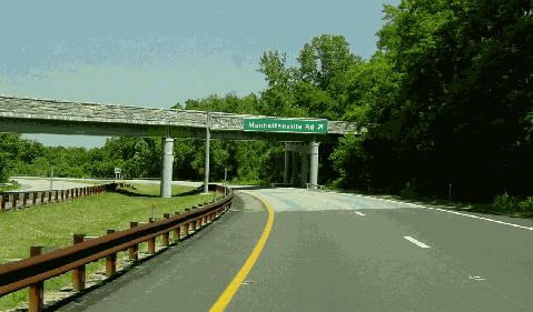
This 2002 photo shows the northbound spur connecting the Hutchinson River Parkway to I-684 in Purchase. This spur is designated NY 984J, though there is a reference marker with an I-984J shield at milepost 1.0 on the spur. Just ahead is unsigned EXIT 1A (Manhattanville Road), which serves Manhattanville College and SUNY-Purchase. (Photo by Jim K. Georges.)
|
|
|
|
|
|
|
|
|
|
|
|
|
|
|
|
|
|
THE PUBLIC HEARINGS: Back in eastern Westchester County, the new proposal for the route of I-87 generated tremendous controversy. In February 1962, the NYSDPW held public hearings at the Westchester County Center in White Plains. State engineers wanted to determine by a "full expression of local opinion" whether I-87, the last "sizable" chartered segment of Interstate highway in New York State, should go east or west of Byram Lake in the towns of North Castle and Bedford. The route of I-87 was to also go through two important wildlife sanctuaries and along the eastern end of the Croton Reservoir, one of New York City's primary sources of water. The cost of the segment was $56 million (in 1962 dollars) if the road went along the eastern shore of Byram Lake, $60.5 million if the road went along the western shore.
Many in the crowd, 750 people in all, booed when alternative routes were presented by the NYSDPW. The Westchester Citizens Alliance, a group of landowners in Purchase that questioned the need for I-87, even went so far as to fill the auditorium with gas-filled balloons that read "ROCKY AND 87 GO WEST." Over 100 speakers represented their sides at the public hearing, which lasted from 1:00 PM until 5:00 AM the next morning.
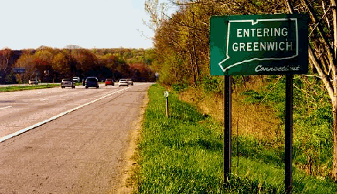
A SHORT RUN THROUGH CONNECTICUT: The new easterly alignment had a 1.4-mile stretch through a corner of Greenwich, Connecticut. In April 1963, Connecticut Governor John Dempsey was asked to approve construction of this segment, so that the road can avoid Rye Lake, an important source of area water supply. Almost immediately, Governor Dempsey faced pressure from anti-highway groups in Westchester and Fairfield counties, and waited to act on construction of this 1.4-mile segment until he received the recommendation of Connecticut Highway Commissioner Howard Ives. In his approval of the route, Ives explained that engineers could find no other path that would do less harm to the area. (Even today, motorists on I-684 are greeted with small signs reading "Entering Greenwich, Connecticut.")
During the mid-1960s, the NYSDPW described the route through Greenwich as follows:
In order to provide a continuous and uninterrupted interstate route section from the vicinity of White Plains to the vicinity of Brewster as aforesaid, the commissioner of transportation is authorized and empowered to enter into an agreement or agreements with the duly authorized representatives of the state of Connecticut in order to provide for the construction and maintenance of necessary connections between said interstate route 502 (I-87) and an interstate route to be constructed through the said excluded section of interstate route 502 running through the western tip of Fairfield County, Connecticut.
|
|
|
|
|
|
|
|
|
|
|
|
|
|
|
 |
|
|
|
|
|
|
|
|
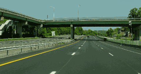
This 2002 photo shows the northbound I-684 at EXIT 6A (NY 22 and NY 138) in Goldens Bridge. The MTA-Metro North Harlem Line (shown at the Goldens Bridge station) runs along the west side of I-684. (Photo by Jim K. Georges.)
|
|
|
|
|
|
|
|
|
|
|
|
|
|
|
|
|
|
|
|
|
|
|
|
 |
|
|
|
|
|
I-684 TAKES SHAPE: Eventually, the NYSDPW recommended to the Federal Government that the route west of Byram Lake - the route recommended by Westchester County - be adopted. It also was planned originally as a four-lane expressway. However, in December 1964, the Bureau of Public Roads approved the final route of I-87 through Westchester and Putnam counties. It was to be constructed east of Byram Lake, and its location between two wildlife sanctuaries was designed to minimize loss to both sanctuaries.
|
|
|
|
|
|
|
|
|
|
|
|
|
|
Engineers already had a head start: part of the route was built on an old right-of-way acquired by the Westchester Northern railroad, an extension of the New York, Westchester and Boston Railroad for a Danbury extension that was graded, but abandoned in 1925. Landscape architects were commissioned to make the expressway - now designed with six lanes - as aesthetically pleasant one for both users and residents along the route.
Further north, from Katonah north to Purdys, the new expressway was to occupy the existing NY 22 right-of-way. However, the small northern Westchester hamlet of Golden's Bridge was in the direct path of the route, and would have to be relocated.
Even as workers broke ground on the highway, Westchester County remained on record as opposing its route on grounds that it served a rural area, not the more developed Mount Kisco area. The Tri-State Transportation Commission disagreed with that assessment, countering that the eastern Westchester corridor was already experiencing rapid growth, necessitating construction of the expressway. In its 1966 report, Transportation 1985: A Regional Plan, the Commission stated its recommendation as follows:
The north-south I-87 through eastern Westchester County will serve a fast-growing suburban area, including major industrial sites. It will provide an expressway route for commercial traffic between I-287 and I-84, and will extend stub-end routes for system continuity.
The first nine-mile segment of the highway, from the Cross Westchester Expressway (I-287) and Hutchinson River Parkway spur in White Plains north to Armonk, opened on October 29, 1968. The following year, an eight-mile segment of I-684 was completed between EXIT 7 (NY 22-NY 116) in Purdys and EXIT 10 (NY 22-US 6-US 202) in Brewster. In 1970, after the I-87 designation was shifted to the New York State Thruway, a new designation, Interstate 684, was assigned to the former I-87. Another five-mile segment, between EXIT 3 (NY 22) in Armonk and EXIT 4 (NY 172) in Bedford Hills, was completed later in 1970.
Bill Sestrom, online producer for The Poughkeepsie Journal and contributor to nycroads.com, summarizes his experience at the opening of I-684:
I drove 684 on the first day it opened. I was an IBM engineer in need of parts at Readers' Digest, and knew 684 had opened that morning, so was lucky enough to catch the first day. I could have done 150 MPH, it was so open! There was a rumor that IBM had some influence on 684, and it does seem to go from Armonk directly to Harrison.
The final six-mile segment of I-684, between EXIT 6 (NY 35-NY 117) in Katonah and EXIT 7 in Purdys, proved the most difficult to build from an engineering and logistical standpoint. Several challenges were posed before the engineers, including blasting through the difficult terrain of the area and constructing two bridges (one carrying NY 138 over I-684 and NY 22, the other carrying I-684 over the Titicus River). During construction, I-684 traffic through this "missing link" choked the newly relocated four-lane NY 22 to the east. (In some locations, NY 22 itself had to be reduced to one lane in each direction.) Finally, the commercial section of Golden's Bridge was relocated to a nearby shopping center at the intersection of NY 22 and NY 138. Construction of the final $18 million segment was completed in December 1974.
After the main highway was completed, the state added two new ramps to southbound I-684 at EXIT 6A (NY 138) in Golden's Bridge and EXIT 7 (NY 116) in Purdys. These ramps were completed in 1976.
|
|
|
|
|
|
|
|
|
|
|
|
|
|
|
 |
|
|
|
|
|
|
|
|
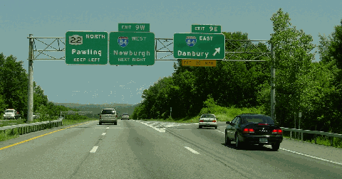
This 2002 photo shows the northbound I-684 at EXIT 9 (I-84), near the northern terminus of the expressway at NY 22 in Brewster. (Photo by Jim K. Georges.)
|
|
|
|
|
|
|
|
|
|
|
|
|
|
|
|
|
|
RECENT IMPROVEMENTS: In recent years, the state made the following improvements to I-684:
The NYSDOT made improvements at EXIT 2 (NY 120) and EXIT 3 (NY 22), both in the Town of North Castle. At EXIT 2, the southbound on-ramp and northbound off-ramp were relocated 1,000 feet to the south of the Airport Access Road intersection, eliminating the current airport-related backups on I-684. At EXIT 3, additional turn lanes and traffic signals were added to the ramps leading to and from NY 22. This improvement, which was part of an overall plan to relieve congestion and improve safety along I-684, NY 120 and NY 22, also featured measures to improve water quality protections at the Kensico Reservoir. The $6.5 million project was completed in 2003.
The NYSDOT made operational and safety enhancements at EXIT 9 (I-84) to coincide with improvements along I-84. To alleviate congestion, some ramps were widened to two lanes. This $2.6 million project was completed in 2003.
The NYSDOT rehabilitated roadways and bridges along I-684 from the Cross Westchester Expressway (I-287) in White Plains north to EXIT 6 (NY 35) in Cross River. After more than three decades of heavy use, the road surface had shown signs of significant deterioration, necessitating the first such rehabilitation project along I-684. The $46 million project was completed in 2007.
According to the NYSDOT, I-684 carries approximately 75,000 vehicles per day (AADT) through Westchester and Putnam counties. In 2004, the state raised the speed limit to 65 MPH along the entire length of I-684, part of a move by Governor George Pataki to raise the limit on 134 miles of highways statewide that meet design and safety standards.
ABOUT THE "ENTERING GREENWICH, CONNECTICUT" SIGN: Who really has jurisdiction over the 1.4-mile segment of I-684 in Connecticut? Ralph Herman, frequent contributor to NYCRoads.com and misc.transport.road, made the following comments:
When I-684 nipped the corner of Connecticut, I believe a compact was signed between New York State and Connecticut which ceded the right of way to New York State, with the stipulation that NYSDOT build and maintain any underpasses or overpasses deemed necessary by Connecticut to "connect" the isolated sliver back to Connecticut. Otherwise, Connecticut would be liable for any damages from resulting highway accidents on that section of I-684. Also, this allows the New York State Troopers to have jurisdiction on the route, not Connecticut State Troopers. Nevertheless, the right-of-way belongs to the state of Connecticut, so the "Entering Greenwich, Connecticut" signs are correct.
Under the 1966 agreement that preceded construction, the New York State Police patrols the Greenwich stretch of I-684 except in the case of fatal accidents and criminal investigations, in which the Connecticut State Police assumes jurisdiction. The NYSDOT performs routine maintenance work and major rehabilitation work along this stretch.
|
|
|
|
|
|
|
|
|
|
|
|
|
|
|
 |
|
|
|
|
|
|
|
|
As the sign above indicates in this 1998 photo, the northbound I-684 clips through Greenwich, Connecticut for 1.4 miles. Nevertheless, this segment is maintained by the New York State Department of Transportation. (Photo by Steve Anderson.)
|
|
|
|
|
|
|
|
|
 |
|
|
|
|
 |
|
|
|
|
|
In keeping with local highway naming conventions, I-684 should be named the "Nelson Rockefeller Expressway" after the longtime governor who made the easterly route possible.
Daniel T. Dey, long-time NYCRoads.com contributor, suggests that I-684 be named the "Hugh Pomeroy Expressway," after the Westchester planning executive who mapped out the county's highway system in the post-war era.
|
|
|
|
|
|
|
|
|
|
|
|
|
|
|
|
|
|
|
|
|
|
 |
|
|
|
 |
|
|
|
|
|
SOURCES: "Freeways Are Now Urged," The New York Times (12/13/1936); Preliminary Plan for Major Thoroughfares in Northern Westchester," Westchester County Planning Department (1956); "Report on the Planning Aspects of the Location of Proposed Interstate Route 87" by Hugh R. Pomeroy, Westchester County Planning Department (3/03/1961); "Interstate Route I-87 in East-Central Westchester," New York State Department of Public Works (February 1962); "A Study of Conflict in Locational Decisions: The Case of the Hudson River Expressway Controversy" by Shaul Amir, University of Pennsylvania (1970); Superhighway - Superhoax by Helen Leavitt, Doubleday and Company (1970); "Interstate Road Will Open in Westchester Today," The New York Times (11/15/1970); "I-684 Offers Urban Traffic Jam in a Pleasant Pastoral Setting" by Edward C. Burks, The New York Times (8/01/1973); "NYSDOT Recommends Plan for Route 120 and I-684 in the Town of North Castle," New York State Department of Transportation (2/18/2000); "I-684's Speed Limit To Be Raised Within Weeks" by Caren Halbfinger and Terry Corcoran, The Journal-News (4/27/2004); "Interstate 684: The Road Less Traveled" by Neil Vigdor, The Greenwich Time (10/07/2005); New York Metropolitan Transportation Council; Patrick DeFeo; Daniel T. Dey; Ralph Herman; David Jackino; Scott Oglesby; Paul Schlictman; Bill Sestrom; Michael Summa; Otto Vondrak; Douglas A. Willinger.
I-684, I-87, and NY 22 shields by Ralph Herman.
|
|
|
|
|
|
|
|
|
|
|
|
|
|
|
|
|
|
|
|
|
|
|
|
|
|
 |
|
|
|
|
|
|
|
|
|
 |
|
|
|
|
|
|
|
|
 |
|
|
|
|
|
|
|
|
|
 |
|
|
|
|
|
THE EXITS OF METRO NEW YORK:
Interstate 684 exit list by Valerie Deane.
|
|
|
|
|
|
|
|
|
|
|
 |
|
|
|
|
|
|
|
|
|
|
|
|
Site contents © by Eastern Roads. This is not an official site run by a government agency. Recommendations provided on this site are strictly those of the author and contributors, not of any government or corporate entity.
|
|
|
|
|
|
|
|
|
|