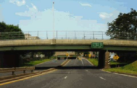
This 1999 photo shows the Whitehead Highway (secret CT 598) snaking its way from I-91 into downtown Hartford. The proposal to convert this highway into I-484 would have widened and straightened the alignment. It would have also extended the highway through a tunnel beneath Bushnell Park and the State Capitol. (Photo by Steve Anderson.)

INITIAL PLANNING: In 1945, the 0.7-mile-long, four-lane Whitehead Highway - part of the South Meadows Expressway also compromising sections of today's I-91 and CT 15 - was opened to traffic in downtown Hartford. The four-lane, pre-lnterstate era freeway connects I-91 with Pulaski Circle at the State Capitol.

Proposals were advanced in the following years for extending the Whitehead Highway through downtown Hartford as an early alignment for the East-West Expressway. In 1949, Robert Moses, New York City arterial coordinator and chairman of the Triborough Bridge and Tunnel Authority, consulted on Hartford's arterial problems for a group of area insurance companies. He opposed its construction as follows:

Regarding the State Highway Department plan to facilitate movement to the new East-West Expressway (I-84) from the central area by drastic widening and grade-separation structures along Jewell Street, we feel that the mere distribution of traffic does not justify these expensive and relatively ineffective changes.

As to the City of Hartford Department of Engineering proposal to continue the Whitehead Highway under Pulaski Circle in a cut and tunnel through Bushnell Park to a connection with the projected East-West Expressway, in our opinion, for what value the public officials concerned and the people of Hartford may attach to it, the continuation of this spur - and we believe it should be essentially nothing but a spur - would be an irreparable mistake, a mistake that would become more and more obvious as increasing traffic is drawn into the Capitol grounds.

No persuasive arguments have reached us for cutting through Bushnell Park. Only three reasons, or rather excuses - none of them valid - are conceivable. First, there is the assumption of some right-of-way engineers that parks exist primarily to afford cheap, convenient and easy locations for heavy traffic. We may dismiss this argument with the assertion that it proves only that the cirricula of our engineering schools need broadening. The extent to which this school of thought will go in relatively small and narrow park areas for heavy vehicular mixed traffic, as distinguished from genuine restricted parkways, is illustrated by a recent proposal of local engineers not only to cut through Bushnell Park with the East-West Expressway, but also to continue through Pope Park, where even traffic needs are not served.

Second, we have the motives to save land acquisition costs, to avoid slum clearance and other difficulties, and to follow what seems superficially the line of least resistance by postponing indefinitely the west crosstown route from the main North-South Expressway (I-91) along the Connecticut River.

The third possible argument for the Bushnell Park route is, if possible, even less impressive than the other two. This is the theoretical planning rule that all arteries should be rims or spokes of a wheel feeding the hub of some all-important midtown area, a piece of academic slide-rule reasoning that has little support under actual conditions, and none where a small landscaped hilltop enshrines the traditions and government of a conservative New England state.

There are, to be sure, public places where deep, new traffic inroads are inescapable, but there have been enough major disturbances of hill and stream in Bushnell Park - no doubt justified by recurring river floods - and further uprooting of topography there should not be encouraged. Our advice, therefore, is to leave Bushnell Park alone, excepting an increase in the size of the Pulaski Circle and a slight widening of Jewell Street.

Ultimately, the alignment of the East-West Expressway (I-84) was shifted to the area north of the Capitol area.

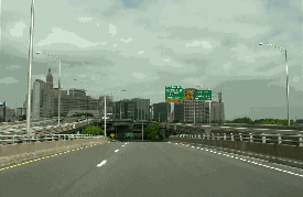
Looking east at the proposed I-484 tunnel through Bushnell Park and the State Capitol, as conceived in the 1972 environmental impact statement developed by ConnDOT. (Photo by Connecticut Department of Transportation.)

A NEW DOWNTOWN CONNECTOR: The postwar era necessitated construction of a statewide network of freeways throughout Connecticut. In 1953, the Connecticut Highway Department proposed freeways along the US 1, US 5 and US 6 corridors, as well as a number of connecting freeways. Under this proposal, the Whitehead Highway was to extend from the US 5 Expressway (today's I-91) west to the US 6 Expressway (today's I-84).

In 1959, the Connecticut Highway Department held initial public hearings on the connector between I-84 and I-91. Three years later, in
Regional Highways: Status Report, the Tri-State Transportation Commission outlined the state highway department's plans for a 1.3-mile-long "Whitehead Highway Improvement." The proposed expressway, which at the time did not have a route designation, was to have the following design characteristics:

  • The existing highway between I-91 and Pulaski Circle was to be expanded to six lanes, and improved to contemporary freeway standards. Specifically, the low-clearance overpasses were to be replaced, and the reverse curves were to be eliminated.

  • West of Pulaski Circle, the six-lane freeway was to be extended for 0.6 mile under a cut-and-cover tunnel through Bushnell Park (behind the State Capitol) before terminating at I-84 (EXIT 48).

  • A full interchange was to be constructed in the vicinity of Pulaski Circle. (According to Scott Oglesby, webmaster of the "Connecticut Roads" site, the circle itself probably would have been reconstructed.)

The proposed expressway, which had a design capacity of 50,000 vehicles per day (AADT), was to not only offer improved access to downtown Hartford, but also provide additional access between I-84 and I-91. (The I-84 / I-91 interchange was left without some freeway-to-freeway ramps in anticipation that the completed Whiteland Highway would provide the additional access.)

PART OF THE INTERSTATE SYSTEM: The "Whitehead Highway Improvement" was originally scheduled for 1968. After being delayed for much of the 1960's, the $46.4 million project received a boost in 1968 when it was added to the Interstate highway system, making it eligible for 90-percent Federal funding. However, under section 4(f) guidelines set forth by the Federal Highway Administration (FHWA), new public hearings had to be conducted since the route went through Bushnell Park.

During 1970, the newly created Connecticut Department of Transportation (ConnDOT) held public hearings on I-484. After rejecting several designs (some due to potential loss of property tax revenue, others due to the completion of I-84 through the area in 1969), ConnDOT presented the cut-and-cover tunnel design under Bushnell Park before the public. City and state officials gave preliminary approval to the revised design, which would have required the displacement of five homes and 55 businesses, but would have added 1.3 acres to Bushnell Park.

THE DEMISE OF I-484: In 1972, ConnDOT released an environmental impact statement on the revised I-484 design, anticipating that the route would be completed two years hence. For years, the route was sidelined by fiscal difficulties and environmental concerns. Support for I-484 had diminished, and in 1979, ConnDOT canceled the Bushnell Park tunnel project, effectively killing I-484. The I-484 designation was officially removed in 1983.

The cancellations of I-484, I-291 and I-491 prompted ConnDOT to conduct the
Greater Hartford Study in 1980. The study made a number of recommendations, including adding the missing ramps at the I-84 / I-91 interchange, constructing HOV lanes on I-84 and I-91, and enhancing mass transit.

Meanwhile, the Whitehead Highway, which has the unsigned CT 598 designation, remains nearly unchanged from its original 1945 design. It features tight curves, short acceleration and deceleration lanes, inadequate median separation (only a single guardrail separates opposing traffic flows), low clearances (less than 14 feet), and a 35 MPH speed limit.

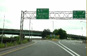
These 2000 photos show the Whitehead Highway (secret CT 598) at the I-91 interchange in Hartford. (Photos by Jim K. Georges.)

SOURCES: Regional Highways: Status Report, Tri-State Transportation Commission (1962); Connecticut Highway Needs, Connecticut Highway Department (1967); Planning for the Future, Connecticut Highway Department (1968); Public Works: A Dangerous Trade by Robert Moses, McGraw-Hill (1970); "Interstate 484: Administrative Action Final Environmental Impact Statement and Section 4(f) Statement," Federal Highway Administration and Connecticut Department of Transportation (1972); "Estimate of the Cost of Completing the National System of Defense Highways in Connecticut," Federal Highway Administration and Connecticut Highway Department (1975); Greater Hartford Study, Connecticut Department of Transportation (1980); Scott Oglesby.

  • I-484 shield by Ralph Herman.

INTERSTATE 484 LINKS:

Back to The Roads of Metro New York home page.

Site contents © by Eastern Roads. This is not an official site run by a government agency. Recommendations provided on this site are strictly those of the author and contributors, not of any government or corporate entity.

Google
 
Web nycroads.com