Bookmark and Share

This 2002 photo shows the westbound I-291 at EXIT 2 (I-91) in South Windsor. I-291 ends just ahead at CT 218. (Photo by Jim K. Georges.)

Length:
Constructed:

6.4 miles (10.3 kilometers)
1956-1994

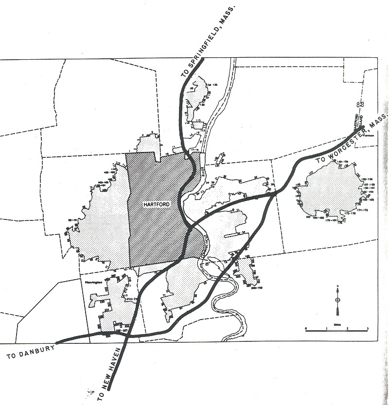
THE ONLY REMNANT OF I-291: In 1957, the Federal Bureau of Public Roads (BPR) added 1,000 miles of new urban routes to the Interstate highway system. One of these routes was I-291, the proposed 26.9-mile-long beltway around the southwest, northwest and northeast quadrants of the Hartford area. Combined with the proposed I-491, which was to serve the southeast quadrant, the two routes were to form a full beltway around Hartford.

Work already had begun on the four-lane Bissell Bridge spanning the Connecticut River between Windsor and South Windsor. Construction of the toll bridge was authorized by the Greater Hartford Bridge Authority, which was charged with developing a multi-bridge plan for the Hartford area. (The Authority was taken over by the Connecticut Highway Department in 1959. Tolls were collected on the bridge until the late 1980's.)

Upon its completion in 1958, the Bissell Bridge and its approaches were designated CT 291 in anticipation of the Interstate route. At that time, CT 291 stretched only 2.5 miles from CT 159 (Windsor Avenue) in Windsor to Main Street in South Windsor. Connections had not yet been constructed to I-91 and US 5.

During its design stages from the late 1950's to the early 1970's, I-291 had been planned as an eight-lane freeway that would not only provide for local access, but also allow for movements between I-84 and I-91. Concerns over community and environmental disruption, as well as a 1974 court injunction stopping all construction, helped killed the southwest and northwest quadrants of I-291 by 1979.

One year later, Neil Goldschmidt, then secretary of the Connecticut Department of Transportation (ConnDOT), deferred action on the northeast quadrant of I-291 based on a draft report of a Federal analysis that found potentially adverse commercial impacts on the towns of Windsor and Vernon, and on the city of Hartford. The "community impact assessment" noted that the effect of the highway on local retail sales, employment, land values and population growth would depend on whether the Buckland Commons shopping mall was built near I-291. Concerns were also raised about the impact on residential areas, which would be cut off by the expressway. A total of 12 families would have to be displaced.

The 5.9-mile-long northeast quadrant of I-291, which was estimated to cost $151 million in 1980, survived only after extensive revisions to the original plan, including scaling down the route to a four-lane freeway with widely spaced exits. These revisions helped win support for I-291 from the towns of Windsor and Manchester, which had previously opposed the expressway.

ConnDOT initiated final design of I-291 in 1984, and four years later, began construction of the freeway. On September 22, 1994, more than 35 years after it was first announced, I-291 opened to traffic from I-91 in Windsor to I-84 in Manchester. New ramps to I-384 in Manchester also opened on this date. The previously opened section of CT 291 over the Connecticut River, included in the new freeway, was re-designated I-291.

According to ConnDOT, Interstate 291 carries approximately 45,000 vehicles per day (AADT). In 1998, ConnDOT increased the speed limit to 65 MPH along the length of I-291.

REINSTATING AN INTERCHANGE: Continued development in the area is prompting local officials to have ConnDOT reinstate plans for EXIT 4A (Burnham Street) on the East Hartford-South Windsor town line. Part of the original I-291 plan but later dropped, the proposed interchange at Burnham Street is intended to relieve congestion on Buckland Street, which runs parallel to I-291 and feeds into I-84 in Manchester.

This 1999 photo shows I-291 looking southeast from EXIT 5 (Tolland Turnpike) in Manchester, just west of the eastern terminus at I-84. (Photo by Steve Anderson.)

"Why, with a metro population of over one million, is there no beltway around downtown Hartford?" - Scott Oglesby, webmaster of "Connecticut Roads"

THE HARTFORD BELTWAY THAT WASN'T: When it was first proposed by the Connecticut Highway Department, I-291 was to play an integral role in directing traffic between I-84 and I-91, and in preventing this traffic from entering downtown Hartford. Surprisingly, I-291 was not included in either the 1944 or 1953 statewide freeway plan. It was only included in the statewide plan in 1957, when the BPR allocated mileage for the freeway, making it eligible for 90-percent Federal funding.

The I-291 and I-491 designations for the Greater Hartford beltway first appeared in 1958. The I-291 section of the beltway incorporated a short section of CT 71 Expressway that the state proposed in the mid-1950's. Public hearings for the route began in 1959. At the time, completion of the I-291 section of the beltway was scheduled for 1970.

DESCRIPTIONS OF THE UNBUILT SECTIONS: The routes for the southwest and northwest sections of I-291 were planned as follows:

  • SOUTHWEST QUADRANT: I-291 was to begin in at I-91 (proposed EXIT 23A) in Rocky Hill. Exposed rock cuts, dirt ramps, and until recently, unused flyover ramps (over I-91) and lightposts were evidence of the future I-291. The expressway was to continue west into Newington, with interchanges at US 5-CT 15 (Berlin Turnpike) and CT 174 (New Britain Avenue). Continuing into New Britain, a short connector (the Taras Shevchenko Expressway, now part of CT 9) was to connect to the CT 72 Expressway. From New Britain north to West Hartford, I-291 was to continue along the original right-of-way for the CT 71 Expressway (and now serves as the route for the CT 9 Expressway). A four-level stack interchange was constructed with I-84 in the late 1960's. This interchange was unused until September 1992, when the final section of the CT 9 Expressway opened to traffic.

  • NORTHWEST QUADRANT: North of I-84, I-291 was to traverse the Hartford reservoir system. After interchanges with CT 4 (Farmington Avenue) and US 44 (Albany Avenue) in West Hartford, I-291 was to have an interchange with a proposed US 44 Expressway in Bloomfield. Veering east toward I-91 in Windsor, I-291 was to have an interchange with the proposed CT 189 Expressway in Bloomfield. An alternate routing for the northwest quadrant had I-291 veer northwest toward CT 10 in Avon before returning to the northeast past US 44.

The 26.9-mile-long I-291 beltway from I-91 in Rocky Hill to I-84 in Manchester was estimated to cost $201.7 million. Construction of I-291 would have displaced 353 homes and 54 businesses. Originally designed to be eight lanes throughout its entire length, I-291 was designed for 80,000 vehicles per day (AADT).

Throughout the 1960s and early 1970s, the route faced significant opposition from the towns of Wethersfield, West Hartford, Avon, Farmington, Bloomfield, Windsor and Manchester. Nevertheless, the Connecticut Department of Transportation (ConnDOT) let out the first construction contracts on the southwest quadrant of I-291 when design work was completed. However, before work could begin, I-291 several major setbacks.

In 1972, the state shelved the northwest quadrant of I-291 from I-84 in Farmington to I-91 in Windsor. Federal and state officials were unable to come to a compromise plan that provide an eight-lane freeway and avoid several reservoirs in the area.

One year later, a lawsuit against ConnDOT and the Federal Highway Administration (FHWA) stopped work on the southwest quadrant of I-291, even as clearing and grading work began. The lawsuit charged that the environmental impact statement (which was approved in 1972) did not address alternative routes such as the CT 9 and CT 72 expressways.

In 1974, a court injunction indefinitely stopped all construction on I-291. The U.S. Environmental Protection Agency (EPA) rejected the environmental impact study previously submitted by ConnDOT because it understated the potential negative impacts from I-291 on the Hartford reservoir system. The EPA also said that mass transit alternatives were not adequately explored. ConnDOT defended its I-291 proposal, contending that mass transit was not viable for this circumferential route.

However, given the anti-highway sentiment of the 1970's, the battle for the western quadrants of I-291 already had been lost. In 1979, ConnDOT canceled this 21-mile-long section of I-291.

The cancellations of I-291, I-484 and I-491 prompted ConnDOT to conduct the
Greater Hartford Study in 1980. The study made a number of recommendations, including adding the missing ramps at the I-84 / I-91 interchange, constructing HOV lanes on I-84 and I-91, and enhancing mass transit. It also called for the completion of the CT 9 Expressway to replace the southwest quadrant of I-291 that had been canceled.

THE TRI-TOWN CONNECTOR: In the late 1980s, ConnDOT officials pushed for a 2.0-mile-long, four-lane arterial highway that was to connect I-91 (proposed EXIT 23A) in Rocky Hill with CT 176 (Main Street) in Newington. The Tri-Town Connector, a median-divided surface arterial with a design speed of 45 MPH, was to have signalized intersections with CT 3 (Maple Street), US 5-CT 15 (Berlin Turnpike) and CT 176. It was to utilize the unused ramps between I-91 and the unbuilt I-291.

The Tri-Town Connector, estimated to cost $27 million, was scheduled to open by 1990. Despite numerous design concessions, there remained significant opposition to the arterial along the I-291 right-of-way. In heated public discussions held during the spring of 1987, residents feared a revival of the I-291 beltway proposal. Subsequently, ConnDOT dropped plans for the connector.

To this day, some officials still favor keeping the right-of-way available for future road use. In 1999, officials in Wethersfield proposed an east-west arterial highway on the former I-291 right-of-way to relieve traffic on nearby CT 175 and CT 287.

This conceptual drawing from 1960 shows the unbuilt I-291 at the Albany Avenue (existing US 44) diamond interchange in West Hartford. Part of the Hartford reservoir system borders the unbuilt I-291, and for this reason, construction of the route was stopped. (Photo by Connecticut Highway Department.)

SOURCES: Regional Highways: Status Report, Tri-State Transportation Commission (1962); Connecticut Highways (1959-1963), Connecticut Highway Department (1963); Connecticut Highway Needs, Connecticut Highway Department (1967); Planning for the Future, Connecticut Highway Department (1968); "Estimate of the Cost of Completing the National System of Defense Highways in Connecticut," Federal Highway Administration and Connecticut Highway Department (1973); "Interstates 91 and 291: Administrative Action Final Environmental Impact Statement and Section 4(f) Statement," Federal Highway Administration and Connecticut Department of Transportation (1973); Greater Hartford Study, Connecticut Department of Transportation (1980); "Anxiety Over Road Plans" by Deborah Gieringer, The New York Times (3/08/1981); "Interstate 291, Windsor to Manchester: Administrative Action Final Environmental Impact Statement and Section 4(f) Statement," Federal Highway Administration and Connecticut Department of Transportation (1981); "Tri-Town Connector: Public Hearings," Connecticut Department of Transportation (1987); Jay Hogan; Neil Kelly; Scott Oglesby; Alexander Svirsky.

  • I-291 shield by Ralph Herman.
  • Lightpost by Millerbernd Manufacturing Company.

INTERSTATE 291--CONNECTICUT LINKS:

INTERSTATE 291--CONNECTICUT CURRENT TRAFFIC CONDITIONS:

INTERSTATE 291--CONNECTICUT VIDEO LINK:

THE EXITS OF METRO NEW YORK:

  • I-291 (Connecticut) exit list by Steve Anderson.

Back to The Roads of Metro New York home page.

Site contents © by Eastern Roads. This is not an official site run by a government agency. Recommendations provided on this site are strictly those of the author and contributors, not of any government or corporate entity.