


|
This 1999 photo shows the beginning of eastbound I-278 at the NJ 439 junction. The wide grassy embankment on the left was to have been used for the westward extension of I-278 toward I-78 in Springfield. (Photo by Raymond C. Martin.) |
||

|
CONNECTING TO THE GOETHALS BRIDGE: The New Jersey section of Interstate 278, originally known as the Union Freeway, was first proposed in 1955 as an urban connecting route in the National System of Interstate and Defense Highways. This six-lane freeway, which was to connect I-78 with the Goethals Bridge, was to provide a relocation of the existing NJ 28. In 1958, the Union Freeway received the I-278 designation. |
||
|
In the late 1960's, the New Jersey Department of Transportation (NJDOT) and the Tri-State Transportation Commission recommended construction of I-278 as follows: |
||

|
This 1999 photo shows the westbound I-278 at the New Jersey Turnpike (I-95), just west of the Goethals Bridge. (Photo by Raymond C. Martin.) |
||
|
EXTENDING I-278 TO I-78: The original plans for I-278 in New Jersey called for an additional 7.7 miles of freeway from US 1-US 9 in Linden northwest to I-78 at EXIT 49 (NJ 124 / Springfield Avenue) in Springfield. An elaborate interchange at EXIT 49, complete with a wide grassy space between the westbound local and express lanes, hints at aborted plans for an I-78 / I-278 / NJ 124 interchange. The proposed I-278 was to have crossed Garden State Parkway in Kenilworth at the Michigan Avenue overpass (just south of EXIT 138) and US 22 in Union near Country Club Drive. |
||
|
In 1967, state officials proposed that the Federal Bureau of Public Roads (BPR) drop from the Interstate highway system the previously authorized Union Freeway Extension, and substitute the Central Jersey Expressway (I-195) in its place. The estimated $100 million cost for the I-278 extension was attributed to condemnation and construction outlays. In contrast, the proposed I-195 was estimated to cost $60 million. Although I-195 was to be 34.6 miles long - longer than the I-278 extension - its route through more sparsely populated areas was less costly to rebuild. |
||
|
The westward extension of I-278 continued to appear on maps through the mid-1970's, but by then, the project already had been killed. George Kowal, New Jersey contributor to nycroads.com, posted the following in the misc.transport.road newsgroup: |
||
|
AND BEYOND TO I-287? Some maps published by the Triborough Bridge and Tunnel Authority (TBTA) placed the I-278 designation along the NJ 24 Freeway west to I-287 in Morristown. In 1970, the state of New Jersey submitted a proposal to revive I-278 between US 1 and I-78, and extend the I-278 designation along NJ 24, in the hope of getting 90 percent Federal funds to finish the freeway. |
||


|
The Federal Highway Administration (FHWA) rejected the proposal. If it had been approved, the I-278 designation would have continued for one mile on the I-78 local lanes between the current EXIT 49 (where I-278 was to join I-78) and EXIT 48 (the NJ 24 Freeway alignment). |
||

|
This 1967 Union County master plan map shows the western terminus of I-278 in the vicinity of I-78 (then under construction) and NJ 124 (then part of NJ 24) in Springfield. According to the master plan, the I-278 / NJ 24 interchange then proposed did not provide for ramps to I-278 in the immediate area, but instead placed I-278 about one mile east along I-78. (Map from Rutgers University-Historical Maps of New Jersey collection, mapmaker.rutgers.edu.) |
||

|
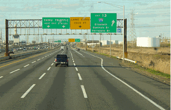
New ramps should be built to connect I-278 westbound with US 1-US 9 northbound, and to connect US 1-US 9 southbound with I-278 eastbound. These new ramps would alleviate congestion by removing through traffic on NJ 439 (Bayway Avenue) in Elizabeth. |
||

|
SOURCES: "New Roads with New Numbers Will Parallel Old U.S. Routes" by George Cable Wright, The New York Times (9/19/1958); Regional Highways: Status Report, Tri-State Transportation Commission (1962); Arterial Progress 1959-1965, Triborough Bridge and Tunnel Authority (1965); Transportation 1985: A Regional Plan, Tri-State Transportation Commission (1966); "Case To Propose More Superroads, Aiding Jersey" by Richard Witkin, The New York Times (8/23/1967); New Jersey Highway Facts, New Jersey Department of Transportation (1967); "Elizabeth Link to Goethals Bridge Set To Open," The New York Times (10/29/1969); "Report on the Status of the Federal-Aid Highway Program," Committee on Public Works, U.S. Senate (1970); "Residents Want Answers on Freight Rail Plan" by Jason Jett, The Star-Ledger (10/08/2002); Chris Blaney; Frank Curcio; Adam Froehlig; George Kowal; Arthur Malkin; Raymond C. Martin; Christopher G. Mason; Dan Moraseski; Scott Oglesby; Paul Payton. |
||
|
INTERSTATE 278 LINKS: |
||
|
INTERSTATE 278-NEW JERSEY CURRENT CONDITIONS: |
||

|
OFF-SITE EXIT LISTINGS: |
||
|
VIEW OR SUBMIT YOUR RATINGS TO RATETHEROADS.COM: |
||

|
|
||

|
Back to The Roads of Metro New York home page. |
||
|
Site contents © by Eastern Roads. This is not an official site run by a government agency. Recommendations provided on this site are strictly those of the author and contributors, not of any government or corporate entity. |
||