

|
|
||
|
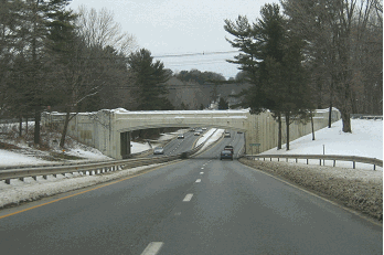
This 2019 photo shows the eastbound I-195 (Central Jersey Expressway) at EXIT 7 (Mercer CR 526) in Washington Township. (Photo by Steve Anderson.) |
||
|
Length: |
||
|
1968-1990 |
||
|
THE CENTRAL JERSEY EXPRESSWAY SYSTEM: In the late 1950s, the New Jersey Highway Authority, which operates the Garden State Parkway, announced plans for the Trenton-Asbury Park Expressway. The proposed four-lane, controlled-access toll road was to link the capital city of Trenton with the New Jersey Turnpike, the Garden State Parkway and points along the north-central New Jersey coast. |
||
|
Several years later, in 1965, Governor Richard J. Hughes urged the creation of a "Central Jersey Expressway System" to improve local and inter-regional access. The system, which was to be constructed under the cooperation of the New Jersey State Highway Department, the New Jersey Highway Authority and the New Jersey Turnpike Authority. |
||
|
The NJ 37 Freeway, which is on new alignment, will become a vital link in providing easy access from the Trenton metropolitan area to New Jersey shore resorts. This east-west route will serve a large area that currently lacks expressway access. The design of the freeway will preserve and enhance the natural beauty of this corridor. Engineering plans are underway. |
||
|
According to the engineering firm Parsons Brinckerhoff, which conducted studies for the system between 1965 and 1967, central New Jersey was expected to grow by 150 percent between 1970 and 1985. The route was recommended as a priority proposal for completion by 1975. |
||
|
That year, NJDOT Commissioner David J. Goldberg, Governor Hughes, U.S. Senator Harrison A. Williams and Congressman James J. Howard proposed to the Bureau of Public Roads (which became the Federal Highway Administration) that Interstate funding be given to the NJ 37 Freeway between Trenton and Belmar. In exchange for providing the 90-10 Federal-state funding for the 34.2-mile-long Central Jersey Expressway, a seven-mile-long unbuilt section of the Union Freeway (I-278) was to be dropped from the Interstate system. The proposed I-195 was estimated to cost $60 million, less than the $100 million estimated for the seven miles of I-278 in Union County. |
||
|
One problem with this proposal was that nationwide, all but 30 miles of the 41,000 National System of Interstate and Defense Highways had been mapped and approved for development, and the remaining 30 miles of the system were to be held in reserve for contingencies. The addition of the I-195 mileage would have exceeded this allocation, even with the swap for the unbuilt section of I-278. Initially, the Bureau of Public Roads (the forerunner to the Federal Highway Administration) rebuffed the New Jersey request. However, with the approval of an additional 1,500 miles into the system in 1968, the Central Jersey Expressway was added to the system as I-195 that year. |
||

|
This 1969 map shows the NJ 37 Freeway -- before it was known as Interstate 195 -- as it was proposed between Trenton and the New Jersey Turnpike. The proposed north-south route is I-295. (Map © 1969 New Jersey Department of Transportation, submitted by Scott Colbert.) |
||
|
DESIGN AND CONSTRUCTION OF I-195: The Central Jersey Expressway was designed to comply fully with Interstate standards. It was to have a 70 MPH design speed, maximum grades of three percent, a 60-foot-wide median (wide enough to accommodate an additional lane in each direction), and a 300-foot-wide right-of-way. Entrances and exits were to be sparsely spaced, averaging three to five miles apart. |
||
|
The proposed alignment of I-195, which was to go through low-density, residentially zoned land in the New Jersey Pine Barrens, required the taking of 41 residences. More than 30 acres of wetlands at the eastern edge of Roebling Park near Trenton were acquired for the interchange between I-195, I-295 and NJ 29. Designed to handle a capacity of 28,000 vehicles per day (AADT), the expressway was to four lanes throughout its entire length, except for one mile in the vicinity of the I-295 interchange, where it was to have six lanes. |
||

|
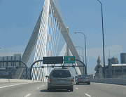
This 2019 photo shows the eastbound I-195 at EXIT 35 (NJ 34) in Wall Township. Although I-195 transitions to NJ 138 at this point, the short freeway extension continues the I-195 exit numbering scheme east to EXIT 36 (Garden State Parkway). (Photo by Steve Anderson.) |
||
|
WIDEN TO SIX LANES IN MERCER COUNTY: The NJDOT should consider building a third travel lane in each direction from EXIT 1 (I-295 / NJ 29) in Hamilton Township east to EXIT 8 (Mercer CR 539) in Robbinsville Township to accommodate increased traffic in the area. |
||

|
SOURCES: "Proposed Trenton-Asbury Park Expressway," New Jersey State Highway Department (August 1964); "New Jersey Highways," New Jersey State Highway Department (1964); "Proposal for a Central Jersey Expressway System," New Jersey State Highway Department (1965); Transportation 1985: A Regional Plan, Tri-State Transportation Commission (1966); "Case to Propose More Superroads, Aiding Jersey" by Richard Witkin, The New York Times (8/23/1967); New Jersey Highway Facts, New Jersey Department of Transportation (1967); "Route 37 Freeway Relocation Study," New Jersey Department of Transportation (1967); "Special Report on the Garden State Parkway and the Central Jersey Expressway System," New Jersey Department of Transportation and New Jersey Highway Authority (1967); "Interstate Routes 195 and 295, New Jersey Routes 29 and 129: Administrative Action Final Environmental Impact Statement and Section 4(f) Statement," Federal Highway Administration and New Jersey Department of Transportation (1981); "I-195 Named for Representative Howard," The Bergen Record (4/07/1988); "Expansion of I-195 Gets Look from DOT" by Joseph Sapia, The Asbury Park Press (8/02/1996); "I-195 Improvements End Great Adventure Backups," The Asbury Park Press (7/17/1997); "DiFrancesco Backs Plan To Expand 65 MPH Speed Limit," The Associated Press (8/15/2001); "New PA Stretch Completes I-95 After 62 Years" by Jason Laughlin, The Philadelphia Inquirer (9/21/2018); Chris Blaney; Scott Colbert; Frank Curcio; Mario Laurenti; Raymond C. Martin; Christopher G. Mason; Dan Moraseski; C.C. Slater; William F. Yurasko. |
||

|
INTERSTATE 195-NEW JERSEY LINKS: |
||
|
INTERSTATE 195-NEW JERSEY CURRENT TRAFFIC CONDITIONS: |
||
|
INTERSTATE 195-NEW JERSEY VIDEOS: |
||

|
THE EXITS OF METRO NEW YORK: |
||

|
Back to The Roads of Metro New York home page. |
||

|
Back to The Roads of Metro Philadelphia home page. |
||
|
Site contents © by Eastern Roads. This is not an official site run by a government agency. Recommendations provided on this site are strictly those of the author and contributors, not of any government or corporate entity. |
||