 |
|
|
|
|
|
|
|
|
|
|
|
|
|
|
|
|
|
|
|
|
|
|
|
|
|
|
|
|
|
|
|
|
|
|
|
|
|
|
|
|
|
|
|
|
|
|
|
|
|
|
|
|
|
|
|
|
|
|
|
|
|
|
|
|
|
|
|
|
 |
|
|
|
|
 |
|
 |
|
|
|
|
|
|
|
|
|
|
|
|
|
|
|
|
 |
|
|
|
|
|
|
|
|
|
|
|
|
|
|
|
 |
|
|
|
|
|
|
|
|
|
|
|
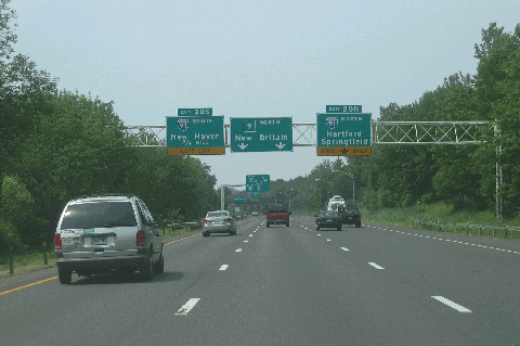
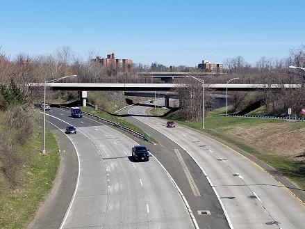
This 2007 photo shows the northbound CT 9 Expressway approaching EXIT 20 (I-91) in Cromwell. (Photo by Steve Anderson.)
|
|
|
|
|
|
|
|
|
 |
|
|
|
|
 |
|
|
|
|
|
|
|
|
|
40.9 miles (65.8 kilometers)
1951-1992
|
|
|
|
|
|
|
|
|
 |
|
|
|
|
 |
|
|
|
|
|
THE ORIGINAL ROUTE 9: One of the original New England "interstate" routes, Route 9 was commissioned in 1932 along the route of the original NE-10, which continued north along the Connecticut River into Massachusetts and New Hampshire. A drive along CT 9, which mostly goes along the Connecticut River valley, reveals rock cuts and other formations exposing layers from different geological eras.
|
|
|
|
|
|
|
|
|
|
|
|
|
|
Since its inception, CT 9 has had its southern terminus in Old Saybrook on Long Island Sound. However, its northern terminus has moved several times over the decades: in 1932 to Granby, in 1945 to Hartford, in 1963 to Wethersfield, and in 1992 to Farmington. (Parts of CT 189, CT 99 and CT 154 have taken over the original Route 9.)
BUILDING THE CT 9 EXPRESSWAY: In the early 1950's, the Connecticut Highway Department proposed a statewide network of controlled-access freeways. The CT 9 Expressway, also called the Central Connecticut Expressway, was planned to connect the US 1 Expressway (eventually built as I-95 / Connecticut Turnpike) in Old Saybrook with the US 5 Expressway (eventually built as I-91) in Berlin.
Toward the end of the 1950's, plans were revised for a 55-mile-long, four-to-six lane CT 9 Expressway stretching from Old Saybrook north to Granby. Design capacities varied from the 35,000 vehicles per day (AADT) along four-lane sections to as high as 80,000 vehicles per day along six-lane sections in the capital area.
The first section, stretching two miles from EXIT 13 (CT 17) north to EXIT 18 (CT 99) in Middletown, opened to traffic in 1951. While offering median separation, this four-lane section does not have complete access controls. Specifically, two signalized intersections remain on along a half-mile stretch between Washington Street and Miller Street.
Other sections of the CT 9 Expressway were opened to traffic through the 1950s and 1960s as follows:
Four-lane section between EXIT 11 (CT 155) and EXIT 13 (CT 17) in Middletown, opened in 1959.
Four-lane section between EXIT 1 (I-95 / Connecticut Turnpike) in Old Saybrook and EXIT 4 (CT 154) in Ivoryton, opened in 1966.
Four-lane section between EXIT 9 (CT 81) in Haddam and EXIT 11 (CT 155) in Middletown, opened in 1966.
Four-lane section between EXIT 4 (CT 154) in Ivoryton and EXIT 9 (CT 81) in Haddam, opened in 1969.
Four-lane section between EXIT 18 (CT 99) in Middletown and EXIT 20 (I-91) in Cromwell, opened in 1969. This interchange included rock cuts and dirt ramps for a proposed western extension to the existing CT 72 Expressway, which ended at US 5 / CT 15 (Berlin Turnpike) in Berlin.
|
|
|
|
|
|
|
|
|
|
|
|
|
|
|
|
|
|
|
 |
|
|
|
|
 |
|
 |
|
|
|
|
|
|
|
|
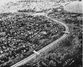
LEFT: This 1960 aerial photo shows the CT 9 Expressway, looking north approaching EXIT 13 (CT 17) in Middletown. RIGHT: Another aerial photo from 1960 shows the CT 9 Expressway, looking south approaching its (then) southern terminus at EXIT 10 (CT 154) in Middletown. (Photos by Connecticut Highway Department.)
|
|
|
|
|
|
|
|
|
|
|
|
|
|
|
|
|
|
|
|
CLOSING THE GAPS BETWEEN I-91 AND I-84: By the end of the 1960s, the CT 9 Expressway closed a triangle with I-91 and I-95. In conjunction with the CT 72 Expressway, I-291 and the New Britain Connector (between CT 72 and I-291), the northern part of the CT 9 Expressway was to form part of Hartford's outer loop. However, more than two decades passed before the CT 9 southwest bypass would be completed. (Other parts of the Hartford outer belt met a less fortuitous fate.)
|
|
|
|
|
|
|
|
|
|
|
|
|
|
The first part of the CT 9 Expressway west of I-91 was actually constructed as part of the CT 72 Expressway. This section, a 2.5-mile-long, four-lane stretch stretching from EXIT 22 (US 5-CT 15) in Berlin north to EXIT 24 (CT 372) in Kensington, opened in November 1962.
The next section of the CT 9 Expressway to have originally carried the CT 72 designation opened in 1979. This 2.1-mile-long, four-to-ten lane section, which connected the Kensington-Berlin section with the newly opened CT 72 Expressway, was constructed as a depressed road through downtown New Britain.
|
|
|
|
|
|
|
|
|
|
|
|
During the late 1970s, another section of expressway was constructed north of the CT 9-CT 72 junction in New Britain. This short, ten-lane-wide section was to connect to the I-291 Hartford beltway, but after the western quadrants of the I-291 beltway were removed from the Interstate system in 1979, the newly built section sat unused for years. The one-mile-long, $12.9 million section, between the CT 9-CT 72 junction and CT 175 in Newington, opened in July 1986. (This section, which was ceremonially named the Taras Shevchenko Expressway, opened with the secret designation CT 506.)
|
|
|
|
|
|
|
|
|
|
|
|
|
|
|
|
|
|
|
|
|
With most of the I-291 project now canceled, the Connecticut Department of Transportation (ConnDOT) focused its energies on completing the CT 9 Expressway. However, its completion was delayed through the late 1980's for two reasons. First, during the course of excavation in Cromwell, archeologists discovered evidence of the Wangunks, one of several early Connecticut River tribes that resided in the area some 6,000 years ago. Second, there was controversy over ConnDOT proposal in New Britain, which would have replaced 14 acres of natural wetlands with 12 acres of newly created wetlands, a move that was done to avoid the city-owned Stanley Golf Course.
In December 1989, the long-delayed gap between EXIT 20 (I-91) in Cromwell and EXIT 22 (US 5 and CT 15 / Berlin Turnpike) in Berlin opened to traffic. The construction project, which saw the opening of a three-mile-long, four-lane segment, included the reconstruction of the interchanges with I-91 and Berlin Turnpike to improve safety (such as the elimination of some existing and proposed left-hand exits). Upon completion of this project, the expressway sections of former CT 72 between Berlin and New Britain received the CT 9 designation.
The final 3.8-mile-long, four-to-six lane section of the CT 9 Expressway opened in September 1992. This section of expressway through Newington and Farmington, which was ceremonially named the Iwo Jima Highway, utilized the former I-291 (CT 71 Expressway) right-of-way that had been purchased by the state highway department some 35 years earlier. It also utilized (if only partially) the four-level "stack" interchange with I-84, which sat unused for more than a quarter century. North of this interchange, constructed stubs reveal plans for the unbuilt I-291. Upon completion of the entire route, this section and the CT 506 (New Britain-to-Newington) section were unified under the CT 9 designation.
REMOVING THE TRAFFIC LIGHTS THROUGH MIDDLETOWN: To this day, two traffic lights in Middletown are all that remain to providing a non-stop CT 9 Expressway. The traffic lights were offered as a compromise when CT 9 was built in the 1950s in an effort to save businesses in Middletown. Over the years, however, this compromise has come at a price. According to ConnDOT statistics obtained by The Middletown Press, there were 528 accidents involving 121 injuries and a single facility in the 2015-2017 three-year period, and when combined with costs related to congestion, the economic burden is about $45 million per year.
ConnDOT plans to begin work in the spring of 2019 on a $75 million modernization of the CT 9 corridor through downtown. The improvements along the CT 9 mainline are as follows:
The existing southbound exit ramp and northbound entrance ramp at EXIT 14 (deKoven Drive), though the acceleration and deceleration lanes will be extended. The at-grade railroad crossing at the southbound exit ramp will be maintained.
The signalized intersection at current EXIT 15 (Washington Street / To CT 66 West) will be removed. At that location, there would be a slip ramp built from Washington Street to southbound CT 9. However, the at-grade railroad crossing at Washington Street will be maintained for this ramp.
There will be a relocated EXIT 15 along northbound CT 9. The exit ramp from northbound CT 9 will be elevated over the southbound lanes of CT 9 and connect to Rapallo Street. Traffic bound for this exit will connect to westbound CT 66.
The signalized intersection at current EXIT 16 (Hartford Avenue / To CT 66 East and CT 17 North) will be removed. At that location, a new bridge to carry the southbound lanes of CT 9 will be built over a new entrance ramp to northbound CT 9. The existing slip ramps to and from southbound CT 9 will be maintained, though the acceleration and deceleration lanes will be extended. The railroad grade separation at Hartford Avenue will be maintained.
The project also will include a reconstruction of Main Street, featuring the creation of 18 sidewalk "bump-outs" designed to reduce pedestrian crossing time, as well as intersection improvements. The entire project is scheduled for completion in late 2022.
THE CT 9 EXPRESSWAY TODAY: Today, the 41-mile-long, north-south CT 9 Expressway complements the north-south I-91, both freeways connecting the capital area with cities and beaches along Long Island Sound. It provides an important bypass of congested Hartford radial routes, and offers freeway service to New Britain and points west via I-84 and the CT 72 Expressway.
According to ConnDOT, the CT 9 Expressway carries approximately 50,000 vehicles per day (AADT) from I-84 south in Farmington to the CT 72 Expressway in New Britain, rising to approximately 75,000 vehicles per day from the CT 72 Expressway south to I-91 in Cromwell, and falling back to approximately 40,000 vehicles per day from I-91 south to I-95 in Old Saybrook. In 1998, ConnDOT raised the speed limit along the length of the CT 9 Expressway, except for a three-mile-long stretch through Middletown, where the speed limit along the at-grade section remains at 45 MPH.
|
|
|
|
|
|
|
|
|
|
|
|
|
|
|
 |
|
|
|
|
|
|
|
|
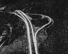
This 2018 photo shows the interchange between the CT 9 and CT 72 expressways in New Britain. It was completed in stages between 1979 and 1986. (Photo by Steve Anderson.)
|
|
|
|
|
|
|
|
|
 |
|
|
|
|
|
|
|
|
|
 |
|
|
|
 |
|
|
|
|
|
|
|
CONTINUING NORTH OF I-84? In the early 1960's, the Tri-State Transportation Commission and the Connecticut Highway Department recommended construction of the CT 9 Expressway from a point west of downtown Hartford north to Granby. When CT 9 was rerouted in 1963, this section was redesignated CT 189. At that time, a 1.7-mile section of the CT 189 Expressway near CT 187 in Bloomfield opened to traffic.
The completion of the CT 189 Expressway south from CT 187 to I-84 was stalled for many years by community opposition. Influenced by public sentiment by the end of the 1970's, official ConnDOT policy shifted toward providing enhanced transit in this corridor, thereby killing the CT 189 Expressway.
CONTINUING ACROSS LONG ISLAND SOUND? In 1965, when the New York State Department of Public Works (NYSDPW) floated plans for the "Atlantic Expressway" along parts of the existing Sunrise Highway (NY 27) and Long Island Expressway (I-495), it included a proposed 10-mile-long bridge from East Marion, New York (between Greenport and Orient Point) and Old Saybrook, Connecticut. The bridge would have been connected to the Connecticut Turnpike (I-95) by a 1.6-mile-long extension of the CT 9 Expressway.
The proposed complex had estimated costs of $206 million for the bridge and $333 million for the expressway connections. Because of mounting construction costs and intense community opposition, officials in New York State canceled this proposal in 1967.
|
|
|
|
|
|
|
|
|
|
|
|
|
|
|
 |
|
|
|
|
|
|
|
|
This 2007 photo shows the at-grade intersection at EXIT 16 (CT 17-CT 66) in Middletown. The Arrigoni Bridge carrying CT 17 and CT 66 across the Connecticut River is in the background. Current ConnDOT plans call for the traffic lights to be replaced by two grade-separated interchanges by 2023. (Photo by Steve Anderson.)
|
|
|
|
|
|
|
|
|
|
|
|
|
|
 |
|
|
|
|
|
EXTENSION TO US 44: Scott Oglesby, creator of the "Connecticut Roads" web site, suggested extending the CT 9 Expressway north to US 44 between Avon and West Hartford. Such a route would provide a much-needed express link to I-84 from the area northwest of Hartford. However, this extension would be challenged by the following factors: extensive development in West Hartford, several reservoirs serving the capital area, and the recent designation of nearby CT 10 as a scenic corridor.
|
|
|
|
|
|
|
|
|
|
|
|
|
|
|
|
|
|
|
|
|
|
|
|
|
|
 |
|
|
|
|
|
SOURCES: Regional Highways: Status Report, Tri-State Transportation Commission (1962); Connecticut Highways (1959-1963), Connecticut Highway Department (1963); "Feasibility Report: Long Island-New England Bridge and Connecting Highways," New York State Department of Public Works (1965); "Long Island-to-Connecticut Bridge and Highway Proposed," The New York Times (1/16/1966); Transportation 1985: A Regional Plan, Tri-State Transportation Commission (1966); Connecticut Highway Needs, Connecticut Highway Department (1967); Planning for the Future, Connecticut Highway Department (1968); "Connecticut Route 9: Administrative Action Final Environmental Impact Statement and Section 4(f) Statement," Federal Highway Administration and Connecticut Department of Transportation (1973); "Expressway Is Making Way for a Historical Dig" by Jacqueline Weaver, The New York Times (6/22/1986); "Feds Halt Last Highway Link," The Associated Press (6/28/1988); "Truck Stop and Rest Area Parking Study," Connecticut Department of Transportation (2000); "Bus Corridor Plans Studied" by Karen Guzman, The Hartford Courant (2/23/2001); "State Unveiling New Plan for Route 9 Traffic" by Matt Austin, WVIT-TV (3/22/2018); "DOT's Revised Project Would Mean Big Changes for Route 9, Downtown Middletown" by Cassandra Day, The Middletown Press (3/26/2018); Jay Hogan; Scott Oglesby; Alexander Svirsky.
CT 9 shield by Barry L. Camp.
Lightposts by Millerbernd Manufacturing Company.
|
|
|
|
|
|
|
|
|
|
|
|
|
|
|
|
 |
|
|
|
|
|
|
|
|
|
 |
|
|
|
|
|
|
|
|
|
 |
|
|
|
|
|
|
|
|
 |
|
|
|
|
|
THE EXITS OF METRO NEW YORK:
CT 9 Expressway exit list by Steve Anderson.
|
|
|
|
|
|
|
|
|
|
|
 |
|
|
|
|
|
|
|
|
|
|
|
|
Site contents © by Eastern Roads. This is not an official site run by a government agency. Recommendations provided on this site are strictly those of the author and contributors, not of any government or corporate entity.
|
|
|
|
|
|
|
|
|
|