 |
|
|
|
|
|
|
|
|
|
|
|
|
|
|
|
|
|
|
|
|
|
|
|
|
|
|
|
|
|
|
|
|
|
|
|
|
|
|
|
|
|
|
|
|
|
|
|
|
|
|
|
|
|
|
|
|
|
|
|
|
|
|
|
|
|
|
|
|
 |
|
|
|
|
 |
|
 |
|
|
|
|
|
|
|
|
|
|
|
|
|
|
|
|
 |
|
|
|
|
|
|
|
|
|
|
|
|
|
|
|
 |
|
|
|
|
|
|
|
|
|
|
|
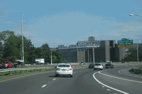
This 2018 photo shows the northbound CT 8 Expressway approaching EXIT 2 (Golden Hill Street-Main Street) in downtown Bridgeport. The southernmost section of CT 8 is signed dually with CT 25. (Photo by Steve Anderson.)
|
|
|
|
|
|
|
|
|
 |
|
|
|
|
 |
|
|
|
|
|
|
|
|
|
58.5 miles (98.2 kilometers)
1951-1983
|
|
|
|
|
|
|
|
|
|
|
|
|
|
 |
|
|
|
|
|
A NEW EXPRESSWAY FOR THE ROUTE 8 CORRIDOR: In 1955, the Connecticut Highway Department began studies for an expressway along the north-south CT 8 corridor from Bridgeport through Waterbury. Two years later, the Connecticut state legislature enacted legislation for the relocation of CT 8 and CT 25, creating controlled-access expressways on new rights-of-way. The original legislation called for a 64-mile-long expressway from Long Island Sound to the Massachusetts border. Cost estimates ranged from $100 million to $120 million.
|
|
|
|
|
|
|
|
|
|
|
|
|
|
|
|
|
|
|
|
|
The mixture of high-speed through traffic and low-speed local traffic, antiquated curve and grading standards, and other unsafe conditions prompted state officials to act quickly on construction of the CT 8 Expressway. On the southernmost section in Bridgeport, the eight-lane expressway was designed for a capacity of 70,000 to 90,000 vehicles per day (average annual daily traffic). Further north, the four-lane sections had a design capacity of up to 35,000 vehicles per day.
The Tri-State Transportation Commission echoed the need for the CT 8 Expressway, stating its purpose and benefits as follows:
The CT 8 Expressway, a north-south route through the Naugatuck Valley, will provide a route perpendicular to the New York-Boston corridor. It will complement downtown urban renewals in Bridgeport and Waterbury, while providing improved access between those cities and their suburbs. It will also connect Interstate routes.
One leading proponent of the development of the CT 8 corridor into an expressway was James Darcey, the longtime editor-in-chief of the Waterbury Republican and American. From Waterbury north to Winsted, the expressway ceremonially bears his name.
CONSTRUCTION PROGRESSES, THEN STALLS: The first section, a four-lane expressway between EXIT 13 (Constitution Boulevard-Bridgeport Avenue) in Shelton and the EXIT 19 (CT 334, Seymour-Ansonia town line), opened in 1959. Incorporated into this section was the four-lane Commodore Hull Bridge over the Housatonic River, which opened on December 17, 1951.
The construction of the CT 8 Expressway progressed as follows:
Four-lane expressway in Naugatuck, from EXIT 26 (CT 63) north to EXIT 29 (Platts Mill Road), opened in 1960.
Four-lane expressway, from EXIT 39 (US 6) in Thomaston north to EXIT 42 (CT 118) in Harwinton, opened in 1960.
|
|
|
|
|
|
|
|
|
|
|
|
Four-lane expressway, from EXIT 19 (CT 334) north to EXIT 22 (CT 67) in Seymour, opened in 1962.
Four-lane expressway, from EXIT 29 (Platts Mill Road) in Naugatuck north to EXIT 39 (US 6) in Thomaston, opened in 1968. This section features an elaborate, double-decked CT 8 Expressway interchanging with a double-decked I-84 (Yankee Expressway) in Waterbury.
|
|
|
|
|
|
|
|
|
|
|
|
|
|
|
|
|
|
|
|
|
|
|
|
|
Four-lane expressway, from EXIT 42 (CT 116) in Harwinton north to EXIT 47 (US 44) in Winsted, opened in 1970.
Expressway section between Bridgeport and Trumbull, varying in width from four to ten lanes, opened in 1972. This 3.8-mile-long section of CT 8, which is multiplexed with CT 25, connects I-95 (Connecticut Turnpike) with EXIT 6 (CT 25 Expressway).
|
|
|
|
|
|
|
|
|
 |
|
|
|
|
|
 |
|
|
|
|
|
|
|
|
|
|
|
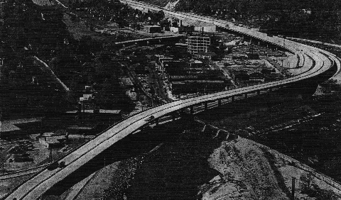
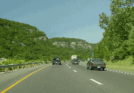
This 1962 photo, which graced the cover of Connecticut Highways magazine, shows an elevated section of the CT 8 Expressway through Seymour. (Photo by Connecticut Highway Department.)
|
|
|
|
|
|
|
|
|
|
|
|
|
|
|
|
|
|
|
|
THROUGH THE FORESTS OF NAUGATUCK: By the early 1970's, with two missing links delayed by community and environmental groups, the completion of the CT 8 Expressway appeared to be in doubt. The first of these missing links, between EXIT 22 (CT 67) in Seymour and EXIT 26 (CT 63) in Naugatuck, was planned to run along the Naugatuck River valley through Naugatuck State Forest. In designing the route of the CT 8 Expressway through the Beacon Falls area, environmental and aesthetic preservation was of utmost concern.
|
|
|
|
|
|
|
|
|
|
|
|
|
|
In 1972, the Connecticut Department of Transportation (ConnDOT) recognized the care that must be taken in constructing this section as follows:
Any aesthetic impact incurred with the construction of this highway can be considered an irreversible investment. Every effort will be made in the design of the project to minimize the aesthetic impact by providing for landscaping in the median and roadside areas, and by blending the proposed alignment, in the reconstructed sections, both vertically and horizontally with the surrounding topography.
The alignment that was selected in this area mostly used the existing CT 8 alignment, thereby requiring the acquisition of only 20 acres of forest and wetlands. This alignment was built along the right-of-way of the Connecticut Company's New Haven-Derby-Naugatuck-Waterbury trolley line, which was abandoned during the 1930's. Aesthetically pleasing, split-level roadways were constructed for the expressway along the Naugatuck River valley.
Leo Auray, Connecticut contributor to nycroads.com and misc.transport.road, made the following observations about the Beacon Falls section of the CT 8 Expressway:
Part of the reason that the section between Seymour and Naugatuck was left for last was that that section had been upgraded before the plans for the highway were drafted, from a point just north of the Route 67 intersection. The pre-expressway Route 8 was a four-lane divided road with at-grade intersections up to the southern end of the Naugatuck State Forest. This stretch looks like it had been built in the late 1940's or early 1950's. Much of this road now lies under the current expressway. However, a section of this road survives intact in Beacon Falls as Route 42. Routes 8 and 42 were multiplexed for a short distance in this area before the Route 8 expressway was built.
As for the old Route 8's path through the Naugatuck State Forest, I seem to remember that the northbound and southbound roadways were separated; the southbound roadway is the current alignment along the river, while the northbound roadway was to the east of the present roadway and a lot higher on the bank. You could not see the river or the southbound roadway from the northbound roadway, from the split just north of Beacon Falls to about the area of Cross Street in Naugatuck. However, these were the observations of a nine-year-old; I've always meant to get out of my car and go for a hike to see if I could find the old roadbed.
When it opened in 1982, this section of the CT 8 Expressway received outstanding design awards from the Federal Highway Administration (FHWA).
INTERSECTING THE MERRITT PARKWAY IN TRUMBULL: Further south, community groups held up construction of the CT 8 Expressway at its proposed interchange with the Merritt Parkway (CT 15). These groups feared that a modern, high-speed interchange would destroy the rural character of the Merritt Parkway. Ultimately, a compromise was reached between ConnDOT and community groups. The proposed interchange with the Merritt Parkway would be a partial interchange, allowing access for six out of eight possible directions.
Construction of the CT 8 Expressway between EXIT 6 (CT 25 Expressway) in Trumbull and EXIT 13 (Constitution Boulevard-Bridgeport Avenue) in Shelton began in 1975. This final section of the expressway was completed in 1983.
|
|
|
|
|
|
|
|
|
|
|
|
|
|
 |
|
 |
|
|
|
|
|
|
|
|
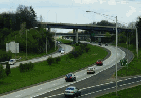
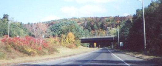
LEFT: This 1999 photo shows the northbound CT 8 Expressway at the Merritt Parkway (CT 15) in Trumbull. This section of the CT 8 Expressway, which was held up for years because of the controversy surrounding the alteration of the Merritt Parkway, opened in 1982. (Photo by Steve Anderson.) RIGHT: This 1999 photo shows the northbound CT 8 Expressway through the Naugatuck State Forest near Beacon Falls. The award-winning design blends the four-lane expressway into the natural setting of the Housatonic River valley. (Photo by Jim K. Georges.)
|
|
|
|
|
|
|
|
|
|
|
|
|
|
|
|
|
|
|
|
|
|
|
|
|
|
|
|
|
|
THE CT 8 EXPRESSWAY TODAY: A drive down the 58-mile-long CT 8 Expressway provides a diverse vista of Connecticut, from the historic industrial towns of Bridgeport and Waterbury, to the modern, sprawling suburbs of eastern Fairfield County, and from the natural beauty of the Naugatuck River valley, to the forests of northwest Litchfield County.
|
|
|
|
|
|
|
|
|
|
|
|
|
|
The early sections of the expressway built in the late 1950s and early 1960s reflect pre- and early-Interstate standards of curve radii, grade percentages, shoulder width and acceleration-deceleration lane length. Newer sections reflect more modern construction standards.
During the mid-to-late 1980's, ConnDOT rebuilt a section of the CT 8 Expressway through the city of Waterbury. Further south, the state also rehabilitated the Commodore Hull Bridge over the Housatonic River, as well as the expressway approaches on both sides of the bridge. A decade later, ConnDOT returned to the Derby area to rebuild EXIT 15 (CT 34 / Main Street). The new $25 million interchange features a 376-foot-long, continuous girder structure.
CURRENT AND FUTURE IMPROVEMENTS: To address congestion and infrastructure maintenance, ConnDOT has undertaken the following projects in recent years, and plans the following projects:
Work was completed in 2004 on upgrading the interchange between the CT 8 Expressway and I-95 in Bridgeport, as part of the rehabilitation of the Connecticut Turnpike through the Bridgeport area. For years, traffic on I-95 leading to EXIT 27A (CT 8-CT 25 Expressway) was backed up for ten miles or more, even during non-rush periods. The new interchange was designed for additional capacity and improved safety.
ConnDOT is studying problems of "underpowered" interchange design and "poor" mainline alignment (low design speeds, too many curves and inadequate sight lines) between EXIT 11 (Bridgeport Avenue-Huntington Road) in Trumbull and EXIT 22 (CT 67) in Seymour. In 1999, ConnDOT released the "Route 8 Corridor Planning" for the portion of the corridor between Shelton and Seymour. Proposed improvements also have been presented at public hearings. Long-term improvements would not come until at least 2010.
In 2007, ConnDOT issued a final study on the "mixmaster" interchange (EXITS 31-32-33) where CT 8 and I-84 meet in downtown Waterbury. The interchange handles approximately 102,000 vehicles per day (AADT), and is expected to handle 127,000 vehicles per day by 2030. In the 2001-2004 study period, there were 1,491 accidents within one mile of the interchange. A preliminary study released in 2005 found entrance and exit ramps were spaced too close together, and that ramps placed on opposite sides of the highway created dangerous weaving conditions that often required motorists to cross three lanes of traffic at once. The recommended alternative suggests the reconstruction of the "mixmaster" as a conventional four-level stack interchange (similar to the I-84 / CT 9 interchange in Farmington) where the northbound and southbound roadways of CT 8 do not cross each other; it also suggests moving the alignment of the northbound lanes of CT 8 east of the Naugatuck River in the area of the interchange. Temporary roadways also would be built through the construction zone. This alternative is estimated to cost $1.3 billion and is targeted for completion by 2020.
According to ConnDOT, the CT 8 Expressway carries approximately 80,000 vehicles per day (AADT) through the Bridgeport are (along the section dually signed with CT 25), falling to approximately 50,000 vehicles per day through the Waterbury area, and to approximately 20,000 vehicles per day near its northern terminus.
In 1998, ConnDOT increased the speed limit on the CT 8 Expressway to 65 MPH from EXIT 37 (CT 262) in Watertown north to its terminus in Winsted. From Watertown south to Bridgeport, the CT 8 Expressway maintains its 55 MPH speed limit.
AN INTERSTATE DESIGNATION FOR ROUTE 8? In 2002, two Connecticut planning agencies and the Waterbury Chamber of Commerce advanced a proposal to create an Interstate designation for the CT 8 Expressway. This idea, which appears in the "I-84 Corridor Transportation Investment Area Initial Corridor Plan," is designed to foster economic growth in Bridgeport and Waterbury. The new Interstate designation also may open the door for Federal highway funds to fix up substandard sections.
|
|
|
|
|
|
|
|
|
|
|
|
|
|
|
 |
|
|
|
|
|
|
|
|
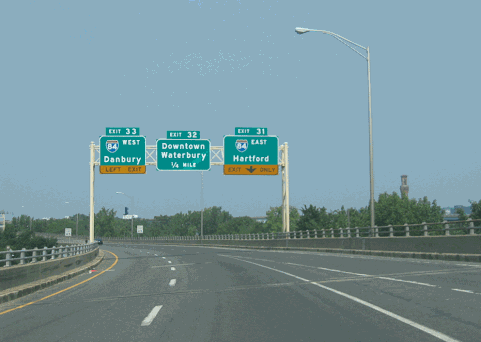
This 2007 photo shows the northbound CT 8 Expressway approaching EXITS 31-32-33 (I-84 and Freight Street / Main Street /Downtown) in Waterbury. Long-term plans call for the reconstruction of this interchange. (Photo by Steve Anderson.)
|
|
|
|
|
|
|
|
|
 |
|
|
|
 |
|
|
|
|
|
|
|
THE UNBUILT CT 8 MAINLINE: In northeastern Litchfield County, there is an approximately 9.5-mile-long section of the CT 8 Expressway between EXIT 47 (US 44) in Winsted and North Colebrook that remains unbuilt. At Winsted, the CT 8 Expressway was to connect to an unbuilt US 44 Expressway. At North Colebrook, the expressway was to continue north across the Connecticut-Massachusetts border.
In 1972, congressmen from Massachusetts lobbied for Interstate funding along the Route 8 corridor in Connecticut, Massachusetts and Vermont. Similarly, officials sought Interstate funding for the Route 7 corridor to the west. Both western New England north-south corridors were denied Federal funding.
Several years earlier, officials from New York State considered an extension of the CT 8 Expressway south to Port Jefferson via a proposed Long Island Sound bridge. The cost of the bridge, as well as for right-of-way acquisition of the proposed southern approach route (Suffolk CR 110 / A.O. Smith Turnpike), proved to be a major stumbling block for the Port Jefferson-Bridgeport Bridge. (Discussion later shifted to a cross-Sound span between New Haven and Shoreham, New York.)
|
|
|
|
|
|
|
|
|
|
|
|
|
|
|
 |
|
|
|
|
|
|
|
|
This 2000 photo shows the northern terminus of the CT 8 Expressway in Winsted, where the carriageway narrows to a single lane at EXIT 47 (US 44). (Photo by "T466.")
|
|
|
|
|
|
|
|
|
 |
|
|
|
|
|
|
|
|
|
|
|
|
|
 |
|
|
|
|
|
SOURCES: "Planning Report: Relocation of Routes 25 and 8," Connecticut Highway Department (1959); "Relocation of Route 8, Winchester," Connecticut Highway Department (1961); Regional Highways: Status Report, Tri-State Transportation Commission (1962); Connecticut Highways (1959-1963), Connecticut Highway Department (1963); Transportation 1985: A Regional Plan, Tri-State Transportation Commission (1966); Connecticut Highway Needs, Connecticut Highway Department (1967); "Proposed Suffolk County to Connecticut Bridge Crossing," Wilbur Smith and Associates (January 1968); Planning for the Future, Connecticut Highway Department (1968); "Relocation of Route 8, Trumbull to Shelton," Connecticut Department of Transportation (1970); "Improvement of Connecticut Route 8, Seymour to Naugatuck, Administrative Action Final Environmental Impact Statement and Section 4(f) Statement," Federal Highway Administration and Connecticut Department of Transportation (1972); "Meskill Scraps Merritt Parkway Plans" by Michael Knight, The New York Times (12/08/1973); "Report Assets Fairfield Needs No New Expressways for Years" by Michael Knight, The New York Times (2/13/1975); "Route 8: Commodore Hull Bridge and Approaches," Connecticut Department of Transportation (1979); "Truck Stop and Rest Area Parking Study," Connecticut Department of Transportation (2000); "The Roads Not Taken" by Caryn Eve Murray, Newsday (5/06/2001); "'Mixmaster' Design Flaws Pointed Out" by Randy James, The Waterbury Republican-American (3/04/2005); Daniel, Mann, Johnson and Mendenhall; Waterbury Chamber of Commerce; Leo Auray; Jay Hogan; Tom Nelligan; Scott Oglesby; Alexander Svirsky.
CT 8 shield by Barry L. Camp.
Lightposts by Millerbernd Manufacturing Company.
|
|
|
|
|
|
|
|
|
|
|
|
|
|
|
|
 |
|
|
|
|
|
|
|
|
|
|
|
|
|
|
|
|
|
|
|
 |
|
|
|
|
|
CT 8 EXPRESSWAY VIDEO LINKS:
|
|
|
|
|
|
|
|
|
|
|
|
 |
|
|
|
|
|
THE EXITS OF METRO NEW YORK:
CT 8 exit list by Steve Anderson.
|
|
|
|
|
|
|
|
|
|
|
 |
|
|
|
|
|
|
|
|
|
|
|
|
Site contents © by Eastern Roads. This is not an official site run by a government agency. Recommendations provided on this site are strictly those of the author and contributors, not of any government or corporate entity.
|
|
|
|
|
|
|
|
|
|