


|
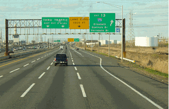
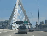
This 1999 photo shows the southbound CT 40 Expressway (Mount Carmel Connector) at EXIT 1 (US 5) in North Haven. (Photo by Steve Anderson.) |
||
|
"Not a whole lot to say. CT 40 is another of those neat little 'let's put in a freeway because we can' deals that Connecticut is prone to." - Neil Kelly |
||
|
THE MOUNT CARMEL CONNECTOR: In 1962, the Tri-State Transportation Commission and the state of Connecticut recommended the construction of a three-mile-long connecting freeway from I-91 in North Haven northwest to the proposed north-south CT 10 Expressway in Mount Carmel. The four-lane freeway, which was to have interchanges with US 5 and the Wilbur Cross Parkway (CT 15), was scheduled for completion in 1965. |
||
|
The Mount Carmel Connector was once again recommended by the Connecticut Highway Department in 1967. Although its route number had not yet been identified, the freeway had been marked as "Item C-40" on the list of expressway projects suggested in the state's 1967-to-1975 construction program. The 3.1-mile, four-lane freeway was estimated to cost $8 million: $3 million was budgeted for right-of-way acquisition, $5 million for construction. |
||

|
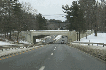
This 2002 photo shows the northern terminus of the CT 40 Expressway in Hamden. CT 40 once was planned to extend west to the CT 10 Expressway, which never was built. (Photo by Douglas Kerr.) |
||

|
EXTENDING NORTHWEST AND SOUTHEAST: To the northwest, the CT 40 Expressway was to be extended to join the unbuilt CT 10 Expressway, a six-lane, limited-access expressway that was to parallel I-91 through much of Connecticut. To the southeast, the highway, originally called the CT 22 Expressway by the Tri-State Transportation Commission, was to be extended beyond I-91. Both the Connecticut Highway Department and the Tri-State Transportation Commission recommended a long-range proposal to extend the expressway southeast, ending at I-95 (Connecticut Turnpike) in Branford. |
||
|
In its 1966 report, Transportation 1985: A Regional Plan, the Tri-State Transportation mentioned the needs and benefits of the CT 22 / CT 40 Expressway as follows: |
||
|
This easterly bypass of New Haven will connect eastern suburbs with industrial areas in the Quinnipiac River. In addition to providing service for an unserved area, it will connect the eastern suburbs with industrial areas in the Quinnipiac Valley. With the Wilbur Cross Parkway (CT 15) and the proposed CT 10 Expressway, it will provide a full bypass of New Haven. |
||

|
This 2000 aerial photo shows the northwest terminus of the CT 40 Expressway at CT 10 in Mount Carmel. The CT 40 Expressway was to provide access to the CT 10 Expressway. Had the CT 10 Expressway connection been built, it would have cut through the residential area on the left. (Photo by Greg Amy.) |
||


|
SOURCES: Regional Highways: Status Report, Tri-State Transportation Commission (1962); Transportation 1985: A Regional Plan, Tri-State Transportation Commission (1966); Connecticut Highway Needs, Connecticut Highway Department (1967); Planning for the Future, Connecticut Highway Department (1968); "Environmental Impact Statement: Administrative Action for Reconstruction of Connecticut Route 40, New Haven," Federal Highway Administration and Connecticut Department of Transportation (1972); Maintaining Mobility, Tri-State Regional Planning Commission (1975); Scott Oglesby; Alexander Svirsky. |
||

|
CT 40 EXPRESSWAY LINKS: |
||
|
CT 40 EXPRESSWAY VIDEO LINK: |
||
|
CT 40 EXPRESSWAY CURRENT CONDITIONS: |
||

|
OFF-SITE EXIT LISTINGS: |
||
|
VIEW OR SUBMIT YOUR RATING TO RATETHEROADS.COM: |
||

|
Back to The Roads of Metro New York home page. |
||
|
Site contents © by Eastern Roads. This is not an official site run by a government agency. Recommendations provided on this site are strictly those of the author and contributors, not of any government or corporate entity. |
||