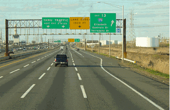
This 2007 photo shows the westbound CT 34 Expressway (Oak Street Connector) through downtown New Haven. (Photo by Steve Anderson.)
THE OAK STREET CONNECTOR: The proposed CT 34 Expressway, also known as the Oak Street Connector, was part of a long-needed overall urban renewal project for the City of New Haven. From Joseph A. Montagna, author of "Urban Renewal in New Haven:"
In 1953, when Richard C. Lee was elected Mayor of the City of New Haven, the city was in a devastatingly gloomy condition. Plans were being formulated by former administrations for the beginning of a renewal program, but the future of New Haven appeared to be as gloomy as its appearance. The downtown district was in poor economic and physical condition and large pockets of slums existed throughout the city. Dick Lee had based his campaign on the promise of a brighter future for New Haven. It took the voters three elections to decide that he was ready for the job. It was Lee who was the catalyst of the chemistry of city planning that was about to occur. In the years to follow, New Haven was given a facelift.
The connector was originally planned to be no more than a spur from the Interstate to the downtown district. Lee and his staff drew up plans that called for three exit ramps at various points that would facilitate smoother traffic flow into the city. The highway department was impressed with this alternative plan and accepted it.
In 1957, the Connecticut state legislature authorized construction of a ten-mile-long freeway along the CT 34 corridor from New Haven northwest to Derby. The proposed freeway was to connect I-91 and I-95 with the CT 8 Expressway. Construction of the initial section of the CT 34 Expressway began that year.
Two years later, the first and only section of the CT 34 Expressway opened to traffic, an event that soon prompted $25 million in new business investment in downtown New Haven. The Oak Street Connector, which also serves the New Haven Coliseum and Yale University, connects to I-91 and I-95 at its eastern terminus. The one-mile-long expressway is eight lanes wide between the I-91 / I-95 terminus and EXIT 2 (College Street), and six lanes between EXIT 2 and the expressway's western terminus at EXIT 3 (York Street and Park Street).
In the late 1990's, the city of New Haven developed plans to add entrance and exit traffic along the CT 34 Expressway to handle traffic from the proposed Long Wharf Galleria. The cancellation of the controversial shopping mall in 2000 placed these plans in jeopardy.
ConnDOT is rebuilding the massive interchange between the CT 34 Expressway, the Connecticut Turnpike (I-95) and I-91 in downtown New Haven. The project includes reconfiguration of the interchange to eliminate left-lane exit and entrance ramps, reconstruction of 18 bridges, addition of new shoulders and a new concrete median barrier, and provisions for two-lane freeway-to-freeway connections wherever possible. Construction began in 2004 and is scheduled for completion in 2016; this project is being carried out in conjunction with the I-95 "Q-Bridge" replacement project.
According to ConnDOT, the CT 34 Expressway carries approximately 70,000 vehicles per day (AADT).
This 1963 aerial photo shows the CT 34 Expressway (Oak Street Connector) extending into the distance from its terminus at the Connecticut Turnpike (I-95). Space was set aside at this interchange for ramps to I-91, which opened through New Haven three years later. (Photo by Connecticut Highway Department.)
EXTENDING WEST TO DERBY: The original Connecticut Highway Department plans for the CT 34 Expressway called for a six-lane freeway with service roads from downtown New Haven west to CT 10 (Ella T. Grasso Boulevard). Including service roads, the expressway was to occupy a 270-foot-wide right-of-way. The service roads, which were built in the 1950's, were extended west to CT 10, and today carry through CT 34 traffic from the end of the expressway. In between the service roads, the right-of-way remains mostly vacant.
West of New Haven, the CT 34 Expressway was to continue as a four-lane freeway on new right-of-way to the CT 8 Expressway in Derby. The existing CT 34 (Derby Avenue), a four-lane divided boulevard, was completed in 1942 along a former trolley right-of-way. However, the lack of access control along the boulevard slowed traffic and created congestion between New Haven and Derby. Completion of the CT 34 Expressway between New Haven and Derby was originally scheduled for 1970.
Plans for the CT 34 Expressway, which had been advocated by the Tri-State Regional Planning Commission for two decades, were revived in the early 1980's by the Connecticut Department of Transportation (ConnDOT). However, the revised plans called for a shorter expressway that was to terminate near Maltby Lakes in West Haven.
The exit locations for the six-lane expressway extension were to be as follows:
EXIT 3: York Street and Park Street in New Haven, diamond interchange EXIT 4: CT 10 (Ella T. Grasso Boulevard) in New Haven, partial diamond interchange EXIT 5: US 1 Connector and existing CT 34 (Derby Avenue) in West Haven
In New Haven, a number of street and pedestrian overpasses were proposed to cross the "Chinese wall" that would be posed by the CT 34 Expressway. The road was to cross the West River and West River Memorial Park into West Haven over a half-mile-long viaduct. To gain the support of officials in West Haven, ConnDOT proposed a "US 1 Connector," a two-lane, limited-access route connecting the western terminus of the CT 34 Expressway with US 1 in West Haven. The connector was to parallel CT 122 (Forest Road) approximately one-half mile to the west.
The proposed CT 34 Expressway extension, which was to displace 35 homes and 10 businesses, was estimated in 1981 to cost $34.9 million. (This was higher than the $25 million cost estimate from the Tri-State Regional Planning Commission.) Although the extension remains unbuilt, new parking and shopping complexes near Yale University, and over the CT 34 right-of-way, have been constructed so that a future CT 34 Expressway extension can be easily accommodated.
Leo Auray, Connecticut contributor to nycroads.com and misc.transport.road, made the following observations about the parking garage over the proposed western extension:
A few years ago, I went poking under the "Air Rights Garage" (yes, that is the name of the parking garage at the end of the connector) and found that the original concrete roadbed extended all the way back past York Street (the street that passes through the parking garage) to the back of the road cut, the end of which had been shored up with concrete.
The garage was being used for parking. Parking stalls had been striped on the concrete, but so had highway lines, all the way back to the end of the concrete. Within the past year or two, though, they've (not sure who the "they" is, though) paved over the area with a layer of asphalt and added parking lot controls (a card reader and gate) on the state right-of-way. Did ConnDOT abandon it?
More on the residential area west of downtown New Haven from Joseph A. Montagne:
Oak Street was the worst slum area in the city. The area that bordered the downtown district had the distinction of harboring the most decrepit housing in New Haven. The Oak Street Project became the city's first effort in rebuilding. However, there was the problem of relocating the more than 600 families and businesses that were in this neighborhood. After nearly two years had passed, the entire area was leveled and made ready for the Oak Street Connector.
In a 1999 article, The New Haven Chronicle reminded readers of the emptiness along the unbuilt CT 34 Expressway corridor through New Haven:
The (Oak Street) Connector is by far the greatest scar on the face of New Haven. Between Frontage Road and Legion Avenue, north of the official highway, you can still imagine ghosts of neighborhoods that were demolished to make way for the Connector. The older trees that used to line the long-gone streets are still there, now marching solemnly across the median, indicating the old streets' paths. The old roads, interrupted by the violent swath of the connector, remind us of this urban mistake.
IS THE EXPRESSWAY STILL ALIVE? Although the CT 34 Expressway extension appeared in ConnDOT's 1999 Transportation Improvement Program (TIP), and a ConnDOT "value engineering document" indicated the planned extension as an expressway to the vicinity of CT 10 (with grade separations at Howe Street and Park Street), no work was done on this project.
More recent developments point to the conclusion that the CT 34 Expressway extension is dead after all. In 2001, the state proposed an eight-year, $20.5 million project to realign CT 34 along the existing North Frontage Road, and to modify South Frontage Road as a local street. Two years later, the City of New Haven reached an agreement with Pfizer to build a clinical research facility along the former CT 34 right-of-way, effectively thwarting plans to extend the expressway.
MORE AMBITIOUS PLANS TOWARD NEW YORK STATE: During the late 1960's, both the Connecticut Highway Department and the Tri-State Transportation Commission proposed a relocation of CT 34, and extension of the CT 34 Expressway as an east-west freeway through Fairfield and New Haven counties. Designed to relieve congestion on I-95 (Connecticut Turnpike) and CT 15 (Merritt Parkway), the proposed CT 34 Expressway extension was planned to connect the CT 8 Expressway in Derby with the US 7 Expressway in Ridgefield, and extend further west (via CT 35) to the proposed NY 35 (Northern Westchester) Expressway into Westchester County.
In its 1966 report, Transportation 1985: A Regional Plan, the Tri-State Transportation Commission recommended construction of the highway (which was originally designated in the report as the "CT 34" and "CT 110" expressways) as follows:
This existing stub-end route will be extended west through the New Haven urban area, and will be tied in with a redevelopment program. Continuing west, it will connect rapidly developing suburbs in New Haven, Fairfield and Westchester counties. It will also relieve pressure on existing radial routes.
The Tri-State Transportation Commission designated the CT 34 / NY 35 Expressway complex from Peekskill to New Haven as a "long-range" proposal for completion by 1985. However, the rising environmental movement and growing public sentiment against new roads led the Regional Plan Association to drop the Peekskill-New Haven expressway proposal from its list of recommended projects in 1975.
In this 2000 aerial photo, the CT 34 Expressway terminates at the Air Rights Garage (shown here in the foreground) in downtown New Haven. The single-level parking lot in the right-of-way for the CT 34 Expressway extension soon will be replaced by a Pfizer clinical research facility. (Photo by Greg Amy.)
SOURCES: Regional Highways: Status Report, Tri-State Transportation Commission (1962); Connecticut Highways (1959-1963), Connecticut Highway Department (1963); Transportation 1985: A Regional Plan, Tri-State Transportation Commission (1966); Connecticut Highway Needs, Connecticut Highway Department (1967); Planning for the Future, Connecticut Highway Department (1968); "Report Assets Fairfield Needs No New Expressways for Years" by Michael Knight, The New York Times (2/13/1975); Maintaining Mobility, Tri-State Regional Planning Commission (1975); "Connecticut Route 34, Administrative Action Final Environmental Impact Statement and Section 4(f) Statement," Federal Highway Administration and Connecticut Department of Transportation (1981); "Greater Bridgeport and Valley Transportation Improvement Program," Greater Bridgeport Valley Metropolitan Planning Organization (1995); "What's the Big Idea: Front Door Follies," The New Haven Advocate (8/05/1999); "$500 Million Long Wharf Mall Canceled" by Charles Enloe, Yale Daily News (12/13/2000); "Pfizer To Locate Research Facility in New Haven," Yale Today (3/31/2003); Leo Auray; Ayan R. Kayal; Joseph A. Montagna; Dan Pagliaro; Scott Oglesby; Alexander Svirsky.
CT 34 shield by Barry L. Camp. NY 35 shield by Ralph Herman. Lightpost by Millerbernd Manufacturing Company.