


|
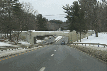
This 1999 photo shows the eastbound CT 3 Expressway in Glastonbury, approaching its eastern terminus at the CT 2 Expressway. (Photo by Steve Anderson.) |
||
|
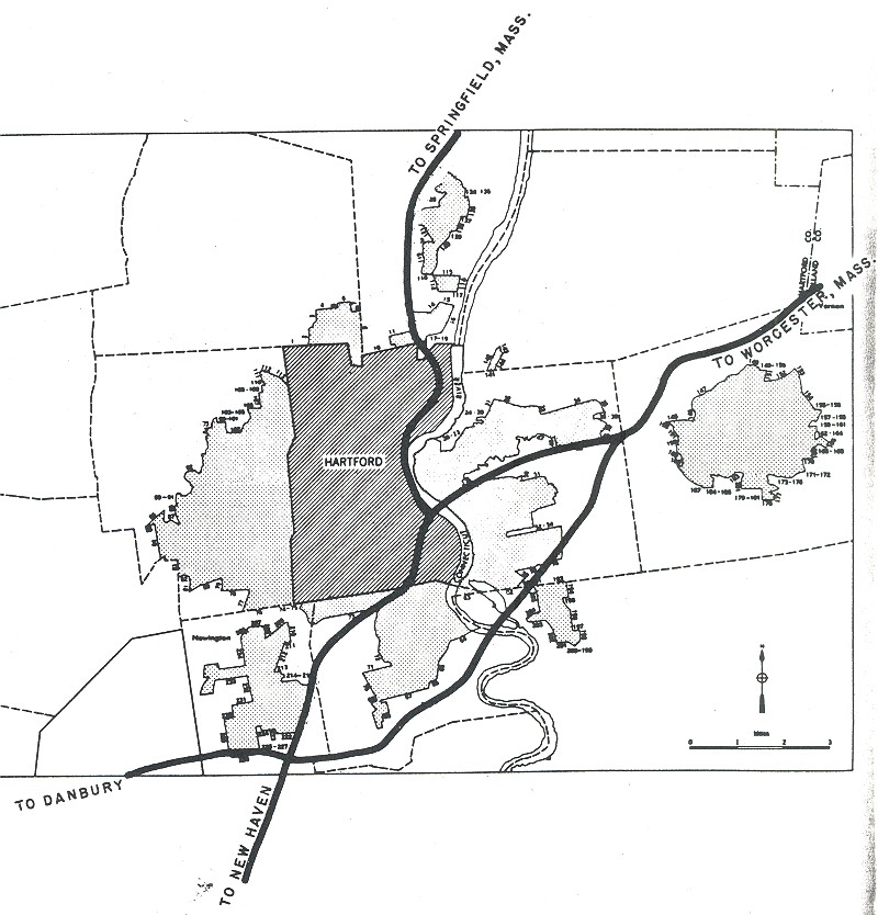
THE WETHERSFIELD-GLASTONBURY EXPRESSWAY: In 1955, Governor Abraham Ribicoff established a new agency, the Greater Hartford Bridge Authority, to develop a multi-bridge plan for the Hartford region. The plan called for the construction of a new Connecticut River crossing between Wethersfield and Glastonbury, as well as for the expansion of existing toll facilities across the Connecticut River. (The Authority was taken over by the Connecticut Highway Department in 1959. Tolls were collected on the Connecticut River facilities until the late 1980's.) |
||
|
The four-lane Glastonbury Bridge - later renamed the William Putnam Memorial Bridge - opened in January 1959 after more than two years of construction. When it opened, its approaches stretched from existing CT 3 (Maple Street) in Wethersfield east to Naubuc Avenue in Glastonbury. In the early 1960's, a partial interchange with I-91 was constructed at the western bridgehead in Wethersfield. |
||
|
Improvements were made at the western bridgehead, where the CT 3 Expressway meets I-91, in the mid-1990's. In the paragraph below, Scott Oglesby describes the circuitous route that awaited motorists traveling between the two expressways as follows: |
||
|
In 1994, ConnDOT completed a new freeway-to-freeway interchange between I-91 and the CT 3 Expressway that provided nearly all movements. The only direct movements that were not included were from I-91 northbound to CT 3 southbound, and from CT 3 northbound to I-91 southbound. |
||
|
This 1999 photo shows the four-lane Putnam Bridge crossing over the Connecticut River, connecting Wethersfield (where this photo was taken) with Glastonbury. Built in 1959, the original bridge was to be joined by a parallel four-lane span. Together, they would have formed part of I-491. (Photo by Steve Anderson.) |
||
|
A MISSING SOUTHEAST LOOP BETWEEN I-91 AND I-84: The CT 3 designation along the Wethersfield-Glastonbury Expressway was meant to be temporary. The expressway was intended to be part of the eight-lane I-491, which was to form the southeast quadrant of the Greater Hartford beltway. |
||
|
THE I-86 ERA: In October 1968, when I-84 was rerouted east to Providence and the "Wilbur Cross" section of the original I-84 became I-86, the I-491 route between Wethersfield and East Hartford was re-designated I-86. The opening of this section of I-86, which would have allowed motorists traveling between New York and Boston to bypass downtown Hartford, was rescheduled for completion by 1975. |
||

|
However, the southeast Hartford bypass never made it past the planning stages. Opposition remained strong in East Hartford, where some estimated that construction of I-86 through the town would increase the amount of land occupied by state highways from seven percent to ten percent. In 1971, following tumultuous public hearings in Glastonbury and East Hartford, Governor Tom Meskill joined the opposition to I-86, calling the design "incomplete." Two years later, ConnDOT traded in the Federal funds from I-491 / I-86 project to other highway and mass transit projects under the Federal Highway Act of 1973. |
||

|
SOURCES: "US 6, I-84 and I-491: Public Hearings," Connecticut Highway Department (1959); Regional Highways: Status Report, Tri-State Transportation Commission (1962); Connecticut Highways (1959-1963), Connecticut Highway Department (1963); Connecticut Highway Needs, Connecticut Highway Department (1967); Planning for the Future, Connecticut Highway Department (1968); "Estimate of the Cost of Completing the National System of Defense Highways in Connecticut," Federal Highway Administration and Connecticut Highway Department (1973); Greater Hartford Study, Connecticut Department of Transportation (1980); Scott Oglesby; Alexander Svirsky. |
||

|
CT 3 EXPRESSWAY LINKS: |
||
|
CT 3 EXPRESSWAY CURRENT CONDITIONS: |
||

|
OFF-SITE EXIT LISTINGS: |
||
|
VIEW OR SUBMIT YOUR RATING TO RATETHEROADS.COM: |
||

|
Back to The Roads of Metro New York home page. |
||
|
Site contents © by Eastern Roads. This is not an official site run by a government agency. Recommendations provided on this site are strictly those of the author and contributors, not of any government or corporate entity. |
||