
|
|
||
|
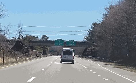
This 2018 photo shows the eastbound CT 2 Expressway at EXIT 18 (CT 16) in Colchester, just west of the split for the CT 11 Expressway. (Photo by Steve Anderson.) |
||
|
Length: |
||
|
37.8 miles (60.8 kilometers) |
||

|
AN EARLY AMERICAN ROAD: The path of Connecticut's Route 2 follows the paths of the Hartford-New London and Colchester-Norwich turnpikes, two early toll roads that date back to the first decade of the nineteenth century. These roads were paid for by tolls before they were converted to local authorities in the mid-1800s. By 1900, the state took over maintenance of what would eventually become Route 2. |
||
|
The paving of CT 2 began in 1920. By 1922, the 120-mile-long "New England Route 17," the precursor to CT 2, opened to traffic between North Canaan in the northwest corner of the state, and Stonington, on the Connecticut-Rhode Island border. A decade later, "NE-17" was decommissioned, and CT 2 was born. (Northwest of Hartford, the remainder of "NE-17" became part of the new US 44.) The new CT 2 was to run 58 miles between East Hartford and Stonington by way of Norwich. |
||
|
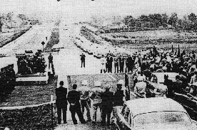
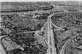
LEFT: The Frank Homski Bridge, which carries the CT 2 Expressway over the Yantic River in Norwich, is dedicated in this 1959 photo. RIGHT: This 1960 aerial view shows the CT 2 Expressway through East Hartford. (Photos by Connecticut Highway Department.) |
||
|
DESIGN AND CONSTRUCTION OF THE CT 2 EXPRESSWAY: Near its western terminus in East Hartford, the CT 2 Expressway takes on a decidedly urban flavor. Tight exit spacing and narrow, concrete "Jersey" barrier-separated medians characterize this older section of expressway. Moving southeast from East Hartford, the CT 2 Expressway takes on a different personality. The newer sections were constructed to contemporary freeway standards, complete with 12-foot-wide lanes, 12-foot-wide shoulders, variable medians and wider spacing between exits. |
||
|
From 1952 to 1971, the CT 2 Expressway was constructed on the following timetable: |
||
|
|
||
|
As the expressway was constructed throughout the 1960s, the state highway department handed over responsibility of the original CT 2 to town authorities. Where the new expressway cut off the original road, some sections of the old road were abandoned altogether. |
||
|
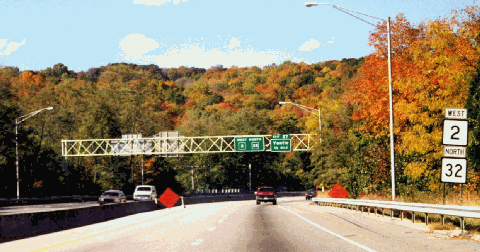
This 1999 photo shows the westbound CT 2 Expressway in Norwich, just west of I-395. This section of the CT 2 Expressway, which is dually signed with CT 32, was to connect with the unbuilt CT 32 Expressway in Yantic. (Photo by Steve Anderson.) |
||
|
RECENT IMPROVEMENTS: Over the years, the Connecticut Department of Transportation (ConnDOT) has made the following interchange improvements to improve safety and traffic flow: |
||
|
According to the Connecticut Department of Transportation (ConnDOT), the CT 2 Expressway carries approximately 65,000 vehicles per day (AADT) through the East Hartford-Glastonbury area, dropping to approximately 25,000 vehicles per day in the Norwich area. In 1998, ConnDOT increased the speed limit to 65 MPH from EXIT 7 (CT 17 Expressway) in Glastonbury to EXIT 26 (CT 32) in Yantic. THE MISSING EXIT 14: Just southeast of EXIT 13 (CT 66 / Hebron Road) in Malborough, the Connecticut Highway Department (the predecessor to ConnDOT) and the Tri-State Transportation Commission had long-range plans for the CT 66 Expressway (originally the US 6A Expressway) to connect with the CT 2 Expressway at the unbuilt EXIT 14. Originally scheduled for completion by 1975, the CT 66 Expressway extension to CT 2 and US 6 had been canceled by that time. |
||
|
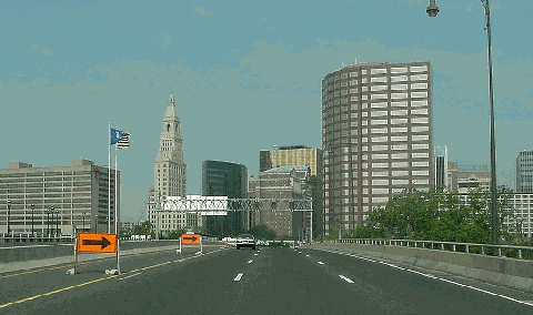
This 2001 photo shows the westbound CT 2 Expressway over the Founders Bridge approaching downtown Hartford. The Founders Bridge was rebuilt during the 1990s. (Photo by Jim K. Georges.) |
||

|
EXTENDING TO RHODE ISLAND: In 1962, the Tri-State Transportation Commission and the Connecticut Highway Department recommended a 21-mile-long, four-lane extension of the CT 2 Expressway from the Connecticut Turnpike (I-395) southeast to the RI 78 Expressway (Westerly Bypass), terminating in Westerly, Rhode Island. |
||
|
Toward the end of the 1970's, ConnDOT opened a 0.4-mile-long, two-lane ("super 2") connection to the RI 78 Expressway (Westerly Bypass). In 1983, ConnDOT opened a ramp from southbound CT 2 to the eastbound Westerly Bypass, utilizing the overpass and right-of-way of (what was to be the four-lane) CT 78 Expressway. Rock cuts at the western terminus of the CT 78 Expressway hint at a possible extension northwest to I-95 and beyond. |
||
|
ALLEVIATING CASINO AND BEACH TRAFFIC: Since the early 1990's, the economy of southeast Connecticut has shifted from one based on defense electronics to one based on tourism. Specifically, the 1992 opening of the Foxwoods casino-resort in Ledyard, followed by the 1996 opening of the Mohegan Sun casino-resort in Montville, have caused traffic volume on CT 2 and other major highways in the area to double. Current and future development in this region is expected to aggravate existing congestion along the CT 2 corridor, the main route to coastal beaches. |
||
|
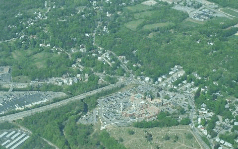
In this 2000 aerial photo, the terminus of the CT 2 Expressway is shown at a conventional intersection in Norwich. Over the years, plans have been devised to extend CT 2 on a new four-lane alignment. (Photo by Greg Amy.) |
||

|
The existing CT 2 Expressway should be widened from four to six lanes between I-84 in East Hartford and the CT 11 Expressway in Colchester. |
||
|
A new CT 78 Expressway should be built to parallel CT 2 from the end of the existing CT 2A Expressway (which would thence be re-designated CT 78) in Preston to the end of the existing CT 78 Expressway in Stonington. The four-lane CT 78 Expressway would alleviate congestion on the existing CT 2. |
||

|
SOURCES: Regional Highways: Status Report, Tri-State Transportation Commission (1962); Connecticut Highways (1959-1963), Connecticut Highway Department (1963); Connecticut Highway Needs, Connecticut Highway Department (1967); "Study for the Relocation of US 6A," Connecticut Highway Department (1967); Planning for the Future, Connecticut Highway Department (1968); "Routes 2-2A-32 Transportation Improvement Study," Connecticut Department of Transportation (1999); "East Hartford Officials Want Road Improvements in Return for Stadium Site," The Associated Press (1/25/2000); "Truck Stop and Rest Area Parking Study," Connecticut Department of Transportation (2000); "The Road Worrier," The Norwich Bulletin (2/12/2001); "Residents Dismayed Group Advises Route 2 Widening" by Megan Bard, The Norwich Bulletin (3/20/2001); "Inventory of Comparative Decking Projects," Parsons, Brinckerhoff, Quade and Douglas (2001); "State Asks Feds for $76 Million for Route 2A Bypass," WFSB-TV (5/16/2003); Jay Hogan; Michael Kendricks; Kevin Lagasse; Scott Oglesby; Alexander Svirsky; William F. Yurasko. |
||
|
CT 2 EXPRESSWAY LINKS: |
||
|
CT 2 EXPRESSWAY CURRENT TRAFFIC MAPS: |
||
|
CT 2 EXPRESSWAY VIDEO LINK: |
||

|
THE EXITS OF METRO NEW YORK: |
||

|
Back to The Roads of Metro New York home page. |
||
|
Site contents © by Eastern Roads. This is not an official site run by a government agency. Recommendations provided on this site are strictly those of the author and contributors, not of any government or corporate entity. |
||