


|
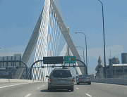
This 2006 photo shows the northbound CT 189 Expressway at the split for CT 187 (South Main Street) in North Bloomfield. (Photo by Steve Anderson.) |
||
|
Planning for the CT 189 Expressway began in the late 1940's, when state and regional officials proposed a landscaped parkway in Hartford's western suburbs. The north-south route, which was to provide full access control, was to connect the East-West Expressway (today's I-84) with the Northwest Expressway (US 44, unbuilt). It was to be constructed along the banks of the North Branch of the Park River. |
||
|
According to plans developed by the Connecticut Highway Department, the Regional Plan Association and the Tri-State Transportation Commission in the early 1960's, the CT 189 Expressway was to be part of an extended CT 9 Expressway. Beginning at the "Sisson Avenue Connector" (EXIT 46 on I-84) in Hartford, the expressway was to have interchanges at the unbuilt I-291 beltway near Bloomfield and at the unbuilt CT 20 Expressway extension near Granby. |
||

|
The CT 189 Expressway through Bloomfield, shown under construction in this 1959 photo. This section was to have been part of an extended CT 9 Expressway. (Photo by Connecticut Highway Department.) |
||

|
THE WOODS RIVER BOULEVARD: In 1947, as part of the postwar development program, the Hartford Department of Engineering proposed a network of controlled-access highways that was to connect Greater Hartford with other parts of Connecticut. One such route, the Woods River Boulevard, was to be a constructed as a landscaped parkway. |
||
|
EXPRESSWAY PLANS THWARTED: In 1955, with automobile-only parkways falling out of favor, the Connecticut Highway Department initiated plans for a controlled-access expressway that would be open to all vehicles. The proposed northern extension of the CT 9 Expressway was to be constructed from I-84 in Hartford north to the vicinity of Granby. Interchanges were to be constructed at Farmington Avenue, US 44, I-291 (unbuilt), CT 187, and either the CT 10 Expressway (unbuilt) or CT 20 Expressway extension (unbuilt). Like the earlier Woods River Boulevard proposal, it was to follow the North Branch of the Park River. |
||
|
The expressway project, now known as CT 189, remained on state highway plans throughout the 1960's, when various proposals were floated to complete the "missing links" of the expressway. A 1968 statewide master highway plan estimated the cost of the 6.3-mile-long, four-lane link at $38 million. It was scheduled for completion by 1975. |
||

|
This 2006 photo shows the Sisson Avenue connector from I-84 EXIT 46 in Hartford. The connector was planned to be part of the CT 189 Expressway. (Photo by Steve Anderson.) |
||


|
SOURCES: Regional Highways: Status Report, Tri-State Transportation Commission (1962); "Expressway Plans," Regional Plan Association News (May 1964); Connecticut Highway Needs, Connecticut Highway Department (1967); Planning for the Future, Connecticut Highway Department (1968); Greater Hartford Study, Connecticut Department of Transportation (1980); "From Here to There," Simon Pure Productions (1998); Scott Oglesby; Alexander Svirsky. |
||

|
CT 189 EXPRESSWAY LINKS: |
||
|
CT 189 EXPRESSWAY VIDEO LINK: |
||
|
CT 189 EXPRESSWAY CURRENT CONDITIONS: |
||

|
OFF-SITE EXIT LISTINGS: |
||
|
VIEW OR SUBMIT YOUR RATINGS TO RATETHEROADS.COM: |
||
|
Back to The Roads of Metro New York home page. |
||
|
Site contents © by Eastern Roads. This is not an official site run by a government agency. Recommendations provided on this site are strictly those of the author and contributors, not of any government or corporate entity. |
||