 |
|
|
|
|
|
|
|
|
|
|
|
|
|
|
|
|
|
|
|
|
|
|
|
|
|
|
|
|
|
|
|
|
|
|
|
|
|
|
|
|
|
|
 |
|
 |
|
|
|
|
|
|
|
 |
|
|
|
|
|
CONNECTIONS FOR THE CHARTER OAK BRIDGE: Extending just over five miles from Berlin Turnpike (US 5 and CT 15) in Wethersfield to I-84 in East Hartford, the CT 15 Expressway, which is dually signed with US 5 for most of its length, provides connections to I-91 and the CT 2 Expressway. The Charter Oak Bridge, which stretches nearly two-thirds of a mile across the Connecticut River, is part of the expressway. Originally, this route, locally known as Wilbur Cross Highway, was planned as an extension of the Wilbur Cross Parkway.
|
|
|
|
|
|
|
|
|
|
|
|
|
|
DEVELOPMENT AND CONSTRUCTION: When the design phase began in 1939, the Wilbur Cross Parkway was envisioned as an extension of the Merritt Parkway from Milford, Connecticut to near Sturbridge, Massachusetts, just north of the Connecticut-Massachusetts border. From there, highway officials in Massachusetts planned an extension of the parkway toward Worcester and Boston.
Construction of the first section of the CT 15 Expressway (then known as the "Hartford Bypass") between Berlin Turnpike (US 5 and CT 15) and Main Street (US 5) in East Hartford, including the Charter Oak Bridge, began in 1940. Progress on the bridge was stymied by material delays, and later, by a tragic setback. On December 4, 1941, a portion of the westerly river span collapsed and fell into the Connecticut River, taking the lives of 16 construction workers.
The six-lane Charter Oak Bridge and four-lane approach highways opened to traffic on September 5, 1942. Tolls were collected in both directions at a plaza in East Hartford. When the 3,016-foot-long bridge (which had a main span of 842 feet) opened, it was the longest continuous plate-girder bridge in the country.
Additional work on the approach highways was delayed due to restrictions placed by the War Production Board. Soon after V-J Day in 1945, work resumed on the Wilbur Cross Highway between the Charter Oak Bridge approach and Berlin Turnpike, and the highway section was completed by the end of that year. Three years later, the highway section was completed through East Hartford. The Wilbur Cross Highway was extended northeast to Sturbridge, Massachusetts between 1948 and 1954, and upgraded to permit use by commercial vehicles.
The entire route of the Wilbur Cross Highway was designated CT 15 in 1948. Unlike the Wilbur Cross Parkway to the south, this route has always been open to both passenger and commercial vehicles. The highway was originally constructed with four lanes (two in each direction), except across the Charter Oak Bridge where there are six lanes (three in each direction).
Berlin Turnpike, a four-lane, arterial boulevard, separates the Wilbur Cross Highway from the Wilbur Cross Parkway. In the immediate postwar years, Connecticut highway officials believed that a controlled-access parkway would be built parallel to Berlin Turnpike in the future, and that a four-lane, at-grade boulevard would be sufficient in the interim. Ultimately, the completion of nearby I-91 in the mid-1960's shelved such proposals.
THE NEW CHARTER OAK BRIDGE AND CT 15 EXPRESSWAY: With the cancellation of I-86 (originally part of I-491) in 1973, the old Wilbur Cross Highway, which was not constructed to contemporary Interstate standards, became the default route for through traffic between New York and Boston. As traffic volumes increased, ConnDOT undertook studies to improve flow and safety on the route, particularly between I-91 and I-84.
|
|
|
|
|
|
|
|
|
|
|
|
|
|
|
|
|
After nearly a decade and a half of studies, ConnDOT unveiled plans to improve the CT 15 (Wilbur Cross) Expressway in 1988. This project, which was to be done in conjunction with another project to improve the nearby I-84 / I-91 interchange in Hartford, was to be paid for by Interstate trade-in funds. Specific features of the plan were a constructing a new six-lane Charter Oak Bridge, upgrading the existing roadway to contemporary standards (e.g., shoulders, acceleration and deceleration lanes), and improving the interchanges at I-91, the CT 2 Expressway, US 5 (Main Street) and I-84.
|
|
|
|
|
|
|
|
|
|
|
|
|
|
|
|
|
|
|
|
|
The beginning of the end for the old Charter Oak Bridge came on April 28, 1989, when William Thornton, who paid the first toll on the bridge in 1942, paid the last toll on the old bridge. The Charter Oak toll plaza was the last one remaining in Connecticut. Work on the new bridge also began that year. While the new bridge was under construction, the old one was dismantled, and motorists were detoured to the Founders and Bulkeley bridges.
On August 8, 1991, more than two years of construction and detours ended when the new Charter Oak Bridge opened to traffic. The new 3,400-foot-long plate-girder bridge has several spans measuring 215 feet in length, and has a vertical clearance of 69 feet above the Connecticut River. Like the old bridge, the new span accommodates six lanes, but unlike the old bridge, it has breakdown shoulders. Along the westbound lanes, there is also a protected pedestrian walkway.
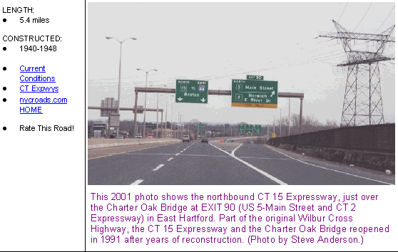
ConnDOT also improved connections on either side of the Charter Oak Bridge. The original cloverleaf at EXIT 90 (US 5) in East Hartford, one of the oldest such interchanges in Connecticut, was converted into a four-ramp interchange. Connections were also simplified at EXIT 87 (I-91) in Hartford, and at EXIT 88 (CT 2 Expressway) in East Hartford. Ramps and acceleration-deceleration lanes were also improved to modern highway standards.
Today, the upgraded CT 15 Expressway and Charter Oak Bridge are mostly used as a Hartford bypass, allowing motorists to travel between New York and Boston via I-84 and I-91. According to ConnDOT, the short Wilbur Cross Highway connector carries approximately 95,000 vehicles per day (AADT).
|
|
|
|
|
|
|
|
|
 |
|
|
|
|
|
 |
|
|
|
|
|
|
|
|
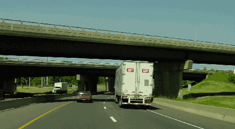
This 2002 photo shows the eastern terminus of the CT 15 Expressway at I-84 in East Hartford. The interchange was rebuilt during the 1980's. (Photo by Jim K. Georges.)
|
|
|
|
|
|
|
|
|
|
|
|
|
|
 |
|
 |
|
|
|
|
|
The CT 15 Expressway between Berlin Turnpike (US 5 / CT 15) in Wethersfield and I-84 in East Hartford, including the Charter Oak Bridge, should be re-designated Interstate 484. Exits on the new I-484 should be re-numbered as follows:
|
|
|
|
|
|
|
|
|
|
|
|
|
|
|
JUNCTION: US 5 / CT 15 / CT 314 (Berlin Turnpike)
EXIT 1 (85): CT 99 (Silas Deane Highway)
EXITS 2 S-N (86-87): I-91
EXITS 3 S-N (88): CT 2 Expressway
EXIT 4 (89): US 5 (Main Street)
EXIT 5 (90): Silver Lane
JUNCTION: I-84
|
|
|
|
|
|
|
|
|
|
|
|
 |
|
|
|
|
|
|
|
|
|
 |
|
|
|
 |
|
|
|
|
|
SOURCES: "Connecticut Opens an Auto Tunnel, Last Link in Wilbur Cross Parkway," The New York Times (11/02/1949); Regional Highways: Status Report, Tri-State Transportation Commission (1962); Connecticut Highway Needs, Connecticut Highway Department (1967); Planning for the Future, Connecticut Highway Department (1968); "Interstates 84 and 86, Administrative Action Final Environmental Impact Statement and Section 4(f) Statement," Federal Highway Administration and Connecticut Department of Transportation (1978); Connecticut's Historic Highway Bridges by Bruce Clouette and Matthew Roth, Connecticut Department of Transportation (1991); "Managing Travel in Connecticut: 100 Years of Progress," Connecticut Department of Transportation (1995); Greater Hartford Convention and Visitors Bureau; Haley and Aldrich, Incorporated; Jay Hogan; Ken Olum; Scott Oglesby; Charles R. Roth; Alexander Svirsky.
CT 15 shield by Barry L. Camp.
I-484 shield by Ralph Herman.
Lightpost by Millerbernd Manufacturing Company.
|
|
|
|
|
|
|
|
|
|
|
|
|
|
|
|
 |
|
|
|
|
|
|
|
|
|
 |
|
|
|
|
|
|
|
|
|
 |
|
|
|
|
|
OFF-SITE EXIT LISTINGS:
CT 15 exit list by Jay Hogan.
|
|
|
|
|
|
|
|
|
|
|
 |
|
|
|
|
|
VIEW OR SUBMIT YOUR RATING TO RATETHEROADS.COM:
CT 15 Expressway
|
|
|
|
|
|
|
|
|
|
|
|
 |
|
|
|
|
|
|
|
|
|
|
|
|
|
|
Site contents © by Eastern Roads. This is not an official site run by a government agency. Recommendations provided on this site are strictly those of the author and contributors, not of any government or corporate entity.
|
|
|
|
|
|
|
|
|
|