 |
|
|
|
|
|
|
|
|
|
|
|
|
|
|
|
|
|
|
|
|
|
|
|
|
|
|
|
|
|
|
|
|
|
|
|
|
|
|
|
|
|
|
|
|
|
|
|
|
|
|
|
|
|
|
|
|
|
|
|
|
|
|
|
|
|
|
 |
|
|
|
|
 |
|
 |
|
|
|
|
|
|
|
|
|
|
|
|
|
|
|
|
 |
|
|
|
|
|
|
|
 |
|
|
|
|
|
|
|
|
|
|
|
|
|
|
|
|
|
|
|
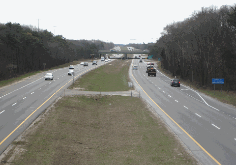
This 2016 photo shows Nicolls Road (Suffolk CR 97) looking south from the Division Street overpass, just north of the Long Island Expressway (I-495) in Holtsville. The Division Street overpass was built in 1975, four years after this section of Nicolls Road was completed. (Photo by Steve Anderson.)
|
|
|
|
|
|
|
|
|
 |
|
|
|
|
 |
|
|
|
|
|
|
|
|
|
14.3 miles (23.0 kilometers)
1961-1975
|
|
|
|
|
|
|
|
|
 |
|
|
|
|
|
|
|
|
One of the many four-lane divided highways constructed in Suffolk County during the 1960s and early 1970s, Nicolls Road serves western Brookhaven and eastern Islip townships. The highway was named after Richard Nicolls, an English colonel who ordered the Dutch to leave western Long Island and New York City in 1664. One year later, Nicolls held a political convention between English settlers from eastern Long Island and the former Dutch subjects to formulate the "Duke's Laws," which contained the civil and criminal codes that covered the newly named colony of "Yorkshire." He eventually became the first governor of the colony that later became Suffolk County.
The northernmost section of highway near the SUNY-Stony Brook campus was built near the site of a "cartpath" that was used as early as the 1700's. This "cartpath" was part of a series of dirt roads that connected farms and towns with the coast. Horse-driven carts carried crops, wood, fertilizer, and construction material from Long Island's interior to New York City and Connecticut.
THE NICOLLS EXPRESSWAY? Plans for Nicolls Road were first revealed in 1957, when Suffolk County proposed a limited-access expressway to connect the new State University of New York at Stony Brook with the South Shore, preferably in the Sayville area. The original plan for the four-lane expressway called for interchanges at NY 25A, SUNY-Stony Brook, Nesconset Highway (NY 347), Middle County Road (NY 25), Portion Road (Suffolk CR 16), the Long Island Expressway (I-495), Veterans Memorial Highway (NY 454), Sunrise Highway (NY 27) and Montauk Highway (NY 27A-Suffolk CR 85).
|
|
|
|
|
|
|
|
|
|
|
|
|
|
|
|
|
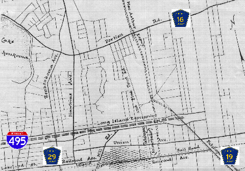
A 1960 proposal by the Suffolk County Planning Department called for a "MacArthur Expressway" that would have followed the Stony Brook-to-Sayville route. It would have crossed the Long Island Expressway near EXIT 61 and continued along the eastern perimeter of Long Island MacArthur Airport.
By 1964, the alignment for the highway was shifted slightly eastward. Instead of continuing directly south from Centereach into developed areas of Lake Ronkonkoma, Holbrook, and Sayville, the new alignment of CR 97 was to veer east, then south into Holtsville and Blue Point.
|
|
|
|
|
|
|
|
|
|
|
|
|
|
|
|
|
|
In its 1966 report, Transportation 1985: A Regional Plan, the Tri-State Transportation Commission recommended the completion of the "Nicolls Expressway" between Stony Brook and Blue Point. It stated the purpose and benefits of the road as follows:
This north-south expressway through central Suffolk County will fill a large gap in the regional highway grid. It will serve a rapidly developing suburban area, including the new State University at Stony Brook, MacArthur Airport and a proposed transportation center.
|
|
|
|
|
|
|
|
|
|
|
|
|
|
|
|
|
|
|
|
 |
|
|
|
|
|
|
|
|
BEFORE NICOLLS ROAD� there was the "MacArthur Expressway," as shown in this proposal from the early 1960's. The north-south expressway, which was to run from Stony Brook to Sayville, was to connect the new SUNY-Stony Brook campus with Long Island MacArthur Airport. (Suffolk County Planning Department map supplied by Daniel T. Dey.)
|
|
|
|
|
|
|
|
|
|
|
|
|
|
|
|
|
|
THE PROGRESS OF NICOLLS ROAD: In 1961, ground first broke for Nicolls Road at its northern terminus in Stony Brook. Construction of Suffolk CR 97 then progressed as follows:
1964: NY 25A (North Country Road) south to NY 347 (Nesconset Highway) in Stony Brook. This initial section serves the SUNY-Stony Brook campus and medical center. Part of this section was constructed along the right-of-way of Oxhead Road (which once ran uninterrupted from Stony Brook to Centereach).
1964: South Coleman Road in Centereach south to Suffolk CR 16 (Portion Road) in Farmingville. This section serves the Selden campus of Suffolk County Community College.
1971: NY 347 (Nesconset Highway) in Stony Brook south to South Coleman Road in Centereach. Along this section, the grade-level intersection with NY 25 (Middle Country Road) in Centereach was replaced with a grade-separated interchange in 1998.
1971: Suffolk CR 16 (Portion Road) in Farmingville south to I-495 (Long Island Expressway) in Holtsville. Along this section, the grade-level intersection with Division Street in Holtsville was replaced with an overpass in 1975.
1975: I-495 (Long Island Expressway) in Holtsville south to NY 27A-Suffolk CR 85 (Montauk Highway) in Blue Point. Along this section, the grade-level intersection with NY 27 (Sunrise Highway) in Holbrook was replaced with a grade-separated interchange in 1990.
Between Portion Road (Suffolk CR 16) in Farmingville and Sunrise Highway (NY 27) in Blue Point, Nicolls Road is a nearly uninterrupted limited-access highway for a five-mile stretch. (One traffic light was installed at Greenbelt Parkway in 1990, breaking this limited-access stretch.) Fiscal concerns prevented construction of a limited-access facility throughout the entire length of Nicolls Road, particularly as the county's road building program died down in the mid-1970s.
LONG ISLAND'S FIRST SPUI: In the late 1990s, a long-delayed reconstruction of the CR 97-NY 25 intersection was completed. A new overpass (which was completed in December 1998) carries for through traffic on Nicolls Road, replacing a signalized intersection with Middle Country Road that had been among the deadliest in Suffolk County for many years.
More on the new interchange from New York State Department of Transportation (NYSDOT) spokesman Jack Donahue:
A full cloverleaf built to current standards was considered, but it would have affected many adjacent properties including a cemetery, a schoolyard and a few commercial businesses. The intersection being constructed will relieve congestion on Middle Country Road by eliminating the through Nicolls Road traffic which will permit more green light time for east-west traffic and left turns. There will be one traffic signal under the overpass that will allow east-west traffic to flow, then left turns from Middle Country Road to Nicolls Road and then left turns from Nicolls Road exit ramps to Middle Country Road. Right turns will be made without a signal.
The CR 97-NY 25 interchange is the first "SPUI" (single-point urban interchange) on Long Island. Unlike the conventional "diamond" interchange, the "SPUI" interchange cinches the exit ramps close together to make them effectively part of the same intersection. At the single-point intersection, which is located beneath the Nicolls Road overpass, opposing left turns from the Nicolls Road exit ramps to Middle Country Road can proceed concurrently without conflict. The "SPUI" ramps were completed in July 1999.
|
|
|
|
|
|
|
|
|
|
|
|
|
|
|
|
|
 |
|
|
|
|
|
|
|
|
This 2003 photo shows the northbound Nicolls Road (Suffolk CR 97) at Sunrise Highway (NY 27) in Holbrook. Nicolls Road does not have numbered exits on its controlled-access portion. (Photo by David Golub.)
|
|
|
|
|
|
|
|
|
|
|
|
|
|
|
|
|
|
|
|
|
|
|
|
|
|
|
|
RECENT IMPROVEMENTS: According to the SCDPW, Nicolls Road carries approximately 25,000 vehicles per day (AADT) in the Blue Point area, rising to approximately 65,000 vehicles per day in the Holtsville area, and peaking at 100,000 AADT near Suffolk County Community College, and falling back to approximately 60,000 AADT in the Centereach area and to 35,000 AADT near Stony Brook University. The NYSDOT and the New York Metropolitan Transportation Council scheduled the following projects along Nicolls Road:
The NYSDOT and SCDPW plan major rehabilitations for the Nicolls Road bridges over Portion Road (Suffolk CR 16) and Patchogue-Holbrook Road (Suffolk CR 19), over a pedestrian walkway at SUNY-Stony Brook, and at the LIRR underpass in Stony Brook. This work was completed in 2007.
As part of its NY 347 reconstruction project, the NYSDOT plans to construct a new grade-separated interchange between CR 97 and NY 347 in Stony Brook. For more than a half-century, the existing at-grade intersection between the two divided highways, through which 90,000 vehicles per day pass (making it the busiest grade-level intersection on Long Island), has been among the deadliest in New York State. A modified cloverleaf design (with flyover ramps) is being considered for the location, but NYSDOT has yet to select a final preferred alternative. Construction of the $140 million interchange is scheduled to begin in 2028 and is targeted for a 2031 completion date.
IS IT TIME FOR A FREEWAY CONVERSION? One long-range proposal being considered among state and county officials is the eventual conversion of Nicolls Road into a six-lane, controlled-access expressway along its entire length, as was originally proposed in the 1960s. Additional lanes would be built within the existing right-of-way.
In 2000, the NYSDOT and the Suffolk County Department of Public Works (SCDPW) began conducting surveys as part of $16 million study to address congestion on Nicolls Road. The SCDPW presented the following alternatives for the highway:
ALTERNATIVE 1 ("NO BUILD"): Improvements would be limited to routing maintenance.
ALTERNATIVE 2 (ADD A LANE): An additional general-use lane would be built in the median of the highway within the existing right-of-way. Existing traffic signals would be maintained.
ALTERNATIVE 3 (CONTROLLED ACCESS, FOUR-LANE): Existing traffic signals would be eliminated between Sunrise Highway (NY 27) and Nesconset Highway (NY 347). A new grade-separated interchange would be built at NY 347. All other existing signals at the Greenbelt Parkway, Horseblock Place, Suffolk County Community College, South Coleman Road, Hammond Road, Hawkins Road, Mark Tree Road, and Pond Path intersections would be removed. Overpasses would be built at these locations, or the intersection would be closed off at these locations by extending the CR 97 median through the intersection.
ALTERNATIVE 4 (CONTROLLED ACCESS, SIX-LANE): Same as alternative 3, but would add an additional general-use lane in the median of the highway within the existing right-of-way.
|
|
|
|
|
|
|
|
|
|
|
|
ALTERNATIVE 5 (CONTROLLED ACCESS, SIX-LANE WITH HOV): Same as alternative 4, but the additional general-use lane would be dedicated to HOV use during morning and afternoon peak periods. These lanes are expected to handle the new "Long Island Rapid Commute" (LIRC) vehicles envisioned by the "LITP 2000" plan.
|
|
|
|
|
|
|
 |
|
|
|
|
|
|
|
|
|
|
|
|
Between 2002 and 2004, the two agencies held public information sessions on future improvements. Early results from the study revealed that more than half of respondents favored converting Nicolls Road into a controlled-access freeway, which the county estimates would cost as much as $400 million for the six-lane "alternative 4." (In comparison, it would cost approximately $120 million just to add a general-use lane in each direction without converting Nicolls Road into an expressway.)
Citing cost concerns, County Executive Steve Levy postponed plans for the freeway alternative in early 2007 and instead is pursuing a $6 million stopgap measure to expand turning lanes at Suffolk County Community College and Horseblock Place. However, some officials continue to favor a full freeway conversion: County Legislator Joe Caracappa (R-Selden) said Nicolls Road in the future "would almost have to become like a Seaford-Oyster Bay Expressway."
OR IS IT TIME TO TAKE THE BUS? In 2016, the SCDPW and the New York Metropolitan Transportation Council (NYMTC) sponsored a study to investigate the possibility of a bus rapid transit (BRT) service using Nicolls Road. The proposed BRT service would connect Stony Brook University, Suffolk County Community College, St. Joseph's University (Patchogue campus), Long Island MacArthur Airport, and LIRR stations in Stony Brook, Ronkonkoma, and Patchogue. Similar to the LITP 2000 plan proposed years earlier, the BRT service likely would require construction of exclusive bus lanes.
|
|
|
|
|
|
|
|
|
|
|
|
|
|
|
 |
|
|
|
|
|
|
|
|
This 2004 photo shows the northbound Nicolls Road (Suffolk CR 97) approaching the exit for Middle Country Road (NY 25) in Centereach. This area was converted from a signalized intersection to a grade-separated "SPUI" interchange in the late 1990s, but rights-of-way for the interchange (originally planned as a cloverleaf) were purchased by the county some 30 years earlier. (Photo by Jon Lebowitz.)
|
|
|
|
|
|
|
|
|
|
|
|
|
|
 |
|
|
|
|
|
BUILD THE NICOLLS EXPRESSWAY: In order to improve north-south traffic flow in central Suffolk County, Nicolls Road should be converted to a six-lane, controlled-access facility built to freeway standards. The right-of-way exists along Suffolk CR 97 for this conversion to take place. In accordance with the 1970 recommendation from the Nassau-Suffolk Regional Planning Board, Nicolls Road should be transferred to the NYSDOT. The exits on the new Nicolls Expressway would be as follows:
|
|
|
|
|
|
|
|
|
|
|
|
|
|
EXITS 1E-W: NY 27A - Suffolk CR 85 (Montauk Highway)
EXIT 2: Suffolk CR 78 (Church Street)
EXITS 3E-W: NY 27 (Sunrise Highway)
EXIT 4: Suffolk CR 19 (Patchogue-Holbrook Road)
EXIT 5: Suffolk CR 90 (Furrows Road)
EXIT 6: Long Island Avenue
EXITS 7E-W: I-495 (Long Island Expressway)
EXITS 8E-W: Suffolk CR 16 (Portion Road)
EXIT 9: South Coleman Road-Suffolk County Community College
EXIT 10: NY 25 (Middle Country Road)
EXIT 11: Mark Tree Road (northbound exit); Hawkins Road (southbound exit)
EXITS 12E-W: NY 347 (Nesconset Highway)
EXIT 13: Stony Brook University-South Entrance
EXIT 14: Stony Brook University-Main Entrance (University Hospital)
EXITS 15E-W: NY 25A (North Country Road)
|
|
|
|
|
|
|
|
|
|
|
|
|
|
|
|
|
|
|
 |
|
|
|
 |
|
|
|
|
|
SOURCES: "Proposed Park-and-Ride Center, Lake Ronkonkoma," Suffolk County Planning Department (1960); Transportation 1985: A Regional Plan, Tri-State Transportation Commission (1966); "Hauppauge-Port Jefferson: State Highway 347 Report," New York State Department of Transportation (1967); "A Drive for New, Wider Roads" by Mara D. Rose, Newsday (2/22/1990); "England Expands Its Empire" by Steve Wick, Newsday (11/25/1997); "New Plans for Route 347 Show a 6-Lane Highway" by Stephanie McCrummen, Newsday (8/30/1998); "Ask Dr. Conehead" by Kim Nava, Newsday (10/18/1998); "Along Route 347, Overpass Jitters" by Stewart Ain, The New York Times (2/14/1999); "Motorist Survey for Nicolls Road" by Barbara LaMonica, Suffolk Life (10/04/2000); "Nicolls Road Corridor Study," Suffolk County Department of Public Works (2002); "History and Geology of Old Nicolls Road" by William Marrs, State University of New York at Stony Brook (2006); "County Plans Nicolls Road Project" by Alex Gillam, The Times of Middle Country (3/02/2007); "Bus Corridor Envisioned for Nicolls Road" by Donna Newman, The Village Times-Herald (12/27/2016); "Nicolls Road Alternatives Analysis," Suffolk County Department of Public Works (2016); "Multiple Proposals Weighed for Nicolls Road/Route 347 Overpass" by William Stieglitz, The Village Times-Herald (6/23/2025); Committee for a New 347; HistoricAerials.com; New York Metropolitan Transportation Council; Suffolk County Historical Society; Suffolk County Planning Department; Daniel T. Dey; Ralph Herman; Nick Klissas; Dan Moraseski; Jim Wade.
Suffolk CR 97 shield by Ralph Herman.
HOV sign by C.C. Slater.
|
|
|
|
|
|
|
|
|
|
|
|
|
|
|
|
 |
|
|
|
|
|
|
|
|
|
 |
|
|
|
|
|
|
|
|
|
 |
|
|
|
|
|
|
|
|
 |
|
|
|
|
|
|
|
|
 |
|
|
|
|
|
|
|
|
 |
|
|
|
|
|
|
|
|
|
|
|
|
Site contents © by Eastern Roads. This is not an official site run by a government agency. Recommendations provided on this site are strictly those of the author and contributors, not of any government or corporate entity.
|
|
|
|
|
|
|
|
|
|