
|
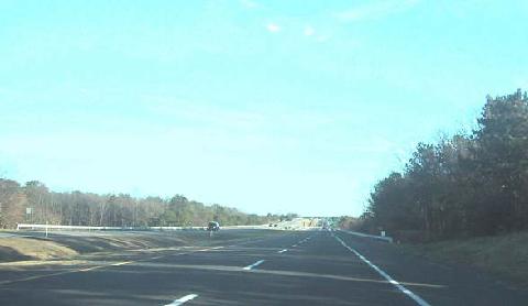
This 2003 photo shows the southbound Port Jefferson-Westhampton Road (Suffolk CR 111) -- also known as Captain Daniel Roe Highway -- just north of Riverhead-Moriches Road (Suffolk CR 51). (Photo by Eric Smith, www.expresswaysite.com.) |
||
|
CONNECTING DEFENSE AND INDUSTRIAL FACILITIES: In 1964, a dotted line between Mount Sinai and Westhampton first started to appear on Suffolk County planning maps. The four-lane divided highway, Port Jefferson-Westhampton Road, was proposed as a limited-access highway proposal in the 1970 Nassau-Suffolk Regional Planning Board transportation plan. |
||
|
Only one segment of Suffolk CR 111, a four-lane arterial highway between the Long Island Expressway and the Sunrise Highway, was completed in early 1975. The completed portion of CR 111, which is also known as Captain Daniel Roe Highway, serves as an important link between I-495 (Long Island Expressway) and NY 27 (Sunrise Highway), or on a larger scale, between New York City and the Hamptons. |
||
|
STOPPED THROUGH THE PINE BARRENS: The unbuilt sections of Port Jefferson-Westhampton Road were stalled for more than another decade. The most contentious segment of right-of-way was through three miles in Manorville, which included the Peconic River headwaters, the Calverton Naval Weapons Industrial Reserve Plant, and the Manorville Historic District. Rudolph Kammerer, the public works commissioner for Suffolk County, had not yet submitted environmental impact statements when he encountered opposition from the Suffolk County Council on Environmental Quality, a non-profit organization opposed to Suffolk CR 111. |
||

|
THE NEW NY 113: First, CR 111 should be extended to its original southern terminus in Westhampton Beach. Next, in order to alleviate seasonal traffic tie-ups, new high-speed ramps should be constructed at EXIT 70 on the Long Island Expressway, allowing for two lanes exiting I-495 east to CR 111 south, and two lanes exiting CR 111 north to I-495 west. In addition, new high-speed ramps should be constructed at EXIT 62 on the Sunrise Highway, allowing for two lanes exiting NY 27 west to CR 111 north, and two lanes exiting CR 111 south to NY 27 east. |
||

|
In accordance with the 1970 Nassau-Suffolk Regional Planning Board recommendation, CR 111 should be transferred to the New York State Department of Transportation (NYSDOT). After the transfer, CR 111 should be re-designated NY 113. |
||

|
SOURCES: "Long Island Regional Transportation Plan," Nassau-Suffolk Regional Planning Board (1970); "Environmentalists Are Cited as Road Blocks" by Fred Tuccillo, Newsday (3/28/1975); "Just Like a Postcard" by Bill Mason, Newsday (3/28/1975); "The Master Plan: Blueprint for Brookhaven," Newsday (2/24/1988); "Highway Hopes That Faded" by Sidney C. Schaer, Newsday (11/05/1999); Central Pine Barrens Joint Planning and Policy Commission; Suffolk County Department of Public Works; Suffolk County Planning Department; Peter Busacca; Daniel T. Dey; Nick Klissas. |
||

|
PORT JEFFERSON-WESTHAMPTON ROAD LINKS: |
||
|
VIEW OR SUBMIT YOUR RATING TO RATETHEROADS.COM: |
||

|
Back to The Roads of Metro New York home page. |
||
|
Site contents © by Eastern Roads. This is not an official site run by a government agency. Recommendations provided on this site are strictly those of the author and contributors, not of any government or corporate entity. |
||