
|
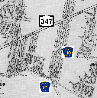
This 1970 map shows the proposed A.O. Smith Turnpike (Suffolk CR 110) running along Wireless Road in South Setauket. On the map running from the middle left to the upper right is Nesconset Highway (NY 347). Shown under construction along the bottom of the map is Nicolls Road (Suffolk CR 97). (Patchogue Chamber of Commerce map supplied by Daniel T. Dey.) |
||
|
A FEEDER ROUTE TO "THE BRIDGE TO BRIDGEPORT:" In 1965, the New York State Department of Public Works (NYSDPW) initiated engineering studies for highway crossings of Long Island Sound between Suffolk County and Connecticut. One study called for a 14.5-mile-long, $219 million bridge between Port Jefferson and Bridgeport. The proposed bridge was to connect to east-west highways by a new north-south road, the $90 million Oakdale-Port Jefferson Expressway. It was to have an eight-lane, 2-2-2-2 configuration for separating local and express traffic. |
||
|
According to 1968 plans by Wilbur Smith and Associates, a New Haven-based engineering and consulting firm, it would have been possible to extend Suffolk CR 110 north of NY 25A onto a proposed bridge between Port Jefferson and Bridgeport, Connecticut. (The route was to continue north as the CT 8 Expressway.) Together, CR 97 and CR 110 would have played a critical role as a north-south expressway corridor feeding into the proposed Port Jefferson-Bridgeport Bridge. |
||
|
Since the proposed bridge and approach roads were thought to cause more disruption relative to other proposed cross-Sound bridge locations, the Port Jefferson-Bridgeport Bridge plan was dropped in favor of the proposed Shoreham-New Haven Bridge, which would ultimately be never built. However, the A.O. Smith Turnpike plan appeared on maps as late as 1982. In this later proposal, Suffolk CR 110 was to be a four-lane, at-grade arterial highway. |
||

|
This 1998 photo shows the Long Island Power Authority (LIPA) right-of-way looking north from Sheep Pasture Road in Setauket. The A.O. Smith Turnpike (Suffolk CR 110) was to have been built along this right-of-way from South Setauket north to Port Jefferson. (Photo by Steve Anderson.) |
||

|
SOURCES: "Feasibility Report: Long Island-New England Bridge and Connecting Highways," New York State Department of Public Works (1965); "Port Jefferson-Connecticut Bridge Site Proposed," The Long Island Advance (3/23/1967); "Hauppauge-Port Jefferson: State Highway 347 Report," New York State Department of Transportation (1967); "Proposed Suffolk County, New York to Bridgeport, Connecticut Crossing," Wilbur Smith and Associates (1968); "Highway Progress and Highway Status Map," Tri-State Transportation Commission (1969); "The Roads Not Taken" by Caryn Eve Murray, Newsday (5/06/2001); A.O. Smith Corporation; Patchogue Chamber of Commerce; Suffolk County Planning Department; Daniel T. Dey; Nick Klissas; Jim Wade. |
||

|
A.O. SMITH TURNPIKE LINK: |
||

|
Back to The Roads of Metro New York home page. |
||
|
Site contents © by Eastern Roads. This is not an official site run by a government agency. Recommendations provided on this site are strictly those of the author and contributors, not of any government or corporate entity. |
||