
|
|
||
|
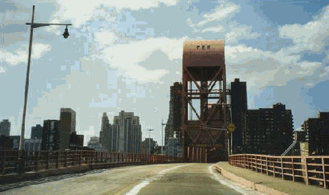
This 1999 photo shows the westbound Roosevelt Island Bridge approaching the main lift span over the East Channel of the East River. Until recently, the bridge featured some of the few remaining "Whitestone"-style lightposts with the original "cuplight" fixtures. (Photo by Steve Anderson.) |
||
|
Type of bridge: |
||
|
Vertical lift |
||
|
HISTORY OF ROOSEVELT (WELFARE) ISLAND: What is known today as Roosevelt Island was first purchased from the Algonquin Indians in 1637 by the Dutch, who promptly renamed the island "Varckens Eylandt," or "Hog Island." In the 1660's, the British reclaimed the island from the Dutch after years of dispute. The island was granted to Captain John Manning, the sheriff of New York. In 1673, Manning was sentenced to death (later commuted to life imprisonment on the island) for relinquishing New York's Fort James to the Dutch without a shot. |
||
|
When Manning died in 1686, stepdaughter Mary Manningham renamed the island after her husband, Robert Blackwell. Blackwell Island remained in private hands until 1828, when the City of New York purchased it and transformed it into a setting for mental institutions, hospitals and prisons. Reflecting this setting as a repository for the down and out, the city renamed the property Welfare Island in 1921. |
||
|
DESCRIPTION OF THE LIFT BRIDGE: Beginning at the corner of Vernon Boulevard and 36th Avenue in Astoria, Queens, the 2,877-foot-long bridge crosses the East Channel of the East River at 40 feet over mean high water. When the 418-foot-long, 1,000-ton vertical-lift span is raised between the bridge's 170-foot-tall towers, a 100-foot clearance is provided for ships. The raising mechanism is provided by 48 cables, each having a breaking strength of 200 tons and balanced by concrete counterweights. On the Roosevelt Island side of the bridge, a helical approach is used to bring the 34-foot-wide roadway down to ground level. Ramps are provided from the approach to a parking garage. A single six-foot-wide pedestrian walkway is also provided along the entire length of the span. |
||
|
More than 3,000 tons of structural steel were used in the construction of the Roosevelt Island span. The most climactic part of the construction came in late 1954, when the lift span that had been constructed on the Astoria shoreline was lifted into place over a two-day period. |
||
|
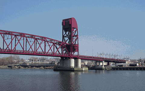
The Roosevelt Island Bridge, crossing over the East Channel of the East River, in its closed position. The Ravenswood generating station and substation in Long Island City, Queens is shown in the background. (Photo by Doug Kerr.) |
||
|
SOURCES: "East River Bridge Two-Thirds Built," The New York Times (4/14/1954); "Mayor To Open Welfare Island Span," The New York Times (5/10/1955); "Welfare Island Gets Own Bridge," The New York Times (5/19/1955); "A Guide to Civil Engineering Projects in and Around New York City," American Society of Civil Engineers (1997); New York City Department of Transportation; Roosevelt Island Operating Corporation; Jeff Saltzman; Kevin Walsh. |
||

|
ROOSEVELT ISLAND BRIDGE LINKS: |
||
|
ROOSEVELT ISLAND BRIDGE CURRENT TRAFFIC MAPS: |
||
|
ROOSEVELT ISLAND BRIDGE VIDEO: |
||


|
PEDESTRIAN AND BICYCLE ACCESS: |
||

|
Back to The Crossings of Metro New York home page. |
||
|
Site contents © by Eastern Roads. This is not an official site run by a government agency. Recommendations provided on this site are strictly those of the author and contributors, not of any government or corporate entity. |
||