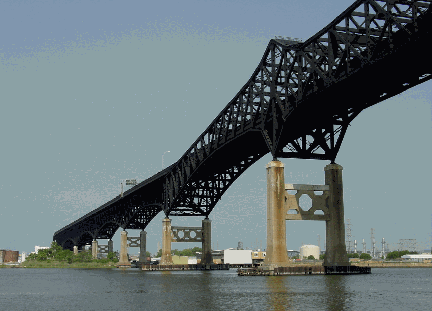
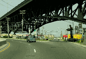
This 2002 photo shows one of the two main spans on the Pulaski Skyway (US 1-US 9). The bridge and skyway crosses the Passaic and Hackensack rivers on its route from Newark to Jersey City. (Photo by Jim K. Georges.)
NEW JERSEY'S CONTRIBUTION TO THE "GOOD ROADS" MOVEMENT: The construction of the Pulaski Skyway, part of the 13.2-mile-long "Route 1 Extension" project, was not only a reaction to the opening of the Holland Tunnel, but also an attempt to address the chronic freight congestion in the area of New York Harbor.
The historical development of the Port of New York, with the majority of the shipping piers located in Manhattan and Brooklyn and the railroad yards located in New Jersey, created an excessively complicated goods handling system - involving a series of transfers between lighters, freight cars and trucks - to handle one-fifth of the nation's transport needs. During World War I, a combined shortage of rolling stock, ships and manpower resulted in a situation where, by November 1917, 180,000 rail cars were trapped in Eastern ports, creating dramatic shortages in the New York area. This congestion, combined with the passage of more than 1.3 million troops during the severe winter of 1917-1918, prompted leaders to press for new highways.
Immediately after World War I, the New Jersey State Highway Department drafted plans to extend Route 1 from Elizabeth, through Newark and Jersey City, to the proposed Hudson River Vehicular Tunnel (now known as the Holland Tunnel) and lower Manhattan. The proposed "express highway" was to have four 10-foot-wide traffic lanes (two in each direction), plus an additional 10-foot-wide lane for emergency use. Other innovations included median separation and grade-separated interchanges.
The following considerations had to be undertaken through Newark and Jersey City:
In Newark, space consideration had to be given to the area where US 22 joins the highway. Another factor that influenced the alignment through Newark was that the city had already acquired a right-of-way that could be utilized from the Newark Airport to the Elizabeth line. Moreover, the Lehigh Valley Railroad had excess right-of-way on high, easily gradable land. By passing over the Oak Island Yard of the Lehigh Valley and Pennsylvania railroads near South Street, the new road would provide easy access between the city of Newark, Newark Airport and Elizabeth Seaport.
In Jersey City, the highway was to cross the high ridge (part of the New Jersey Palisades) before descending to the Holland Tunnel. Connections were also to be provided with Tonnelle Avenue (US 1 and US 9), which was to be the primary route to the (then-proposed) George Washington Bridge. To avoid an open cut through Jersey City - something that the Erie and Pennsylvania railroads had already done to separate the city - the state highway department proposed a subterranean route that lessened the grade over the ridge. The highway was located alongside the Erie Cut, and topped by a roadway. The adopted route, which curved north towards US 1, provided good connections to the local street system.
The state highway department appointed an Advisory Board of Engineers, which was charged with devising plans for handling traffic from the tunnel, laying out a route, and designing a highway to meet the traffic demands of the Holland Tunnel. William G. Sloan, the chief engineer of the state highway department appointed two former railroad engineers to implement the project. Frederick Lavis, who supervised the planning of the Route 1 Extension, had previous experience with the New York City subway system and the Pennsylvania Railroad. Sigvald Johannesson, a graduate of the University of Copenhagen and engineer for the London Underground before coming to New York, worked with Lavis on the Pennsylvania Railroad's Hudson River tubes.
Construction of the $40 million, 13.2-mile-long Route 1 Extension began in May 1923. Originally scheduled for completion in 1926, the extension was delayed by controversy over the routing through the New Jersey Meadowlands.
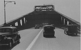
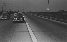
Two 1941 photos of the Pulaski Skyway. Note that the original four-lane configuration did not have a median barrier. (Photos by Library of Congress, Prints and Photographs Division, Marion Post Wolcott Collection, LC-USF33-031246-M1 and LC-USF33-031245-M2.)
DESIGN AND CONSTRUCTION OF THE SKYWAY: As early as 1925, controversy surrounding plans to cross the Hackensack River and Passaic River delayed the Route 1 Extension. A report from the Advisory Board proposed the following alternatives for the 3.5-mile-long "Diagonal Highway" crossing between Newark and Jersey City:
a twin-tube tunnel, accommodating two lanes of traffic in each direction a series of bridges with 40-foot (later reduced to 35-foot) fixed clearances, with vertical-lift spans over the Hackensack River and Passaic River a causeway on the direct line leading diagonally across the meadows, with two 135-foot-high bridges over the Hackensack River and Passaic River
The first alternative was shelved due to cost considerations. Initial applications were made to the U.S. War Department and the State Board of Commerce and Navigation for permission to construct the second alternative over the original diagonal route. However, the permits were denied due to "opposition voiced by navigation interests to additional bridges on these rivers." It was not until October 1929 that the New Jersey State Highway Department agreed to construct the third alternative after study by an advisory commission. Soon thereafter, Federal and state authorities approved the high-level, bridge-causeway complex.
Designed by Sigvald Johannesson, the skyway was engineered by Jacob Baur and H. W. Hudson under the commission of the New Jersey State Highway Department. The two 550-foot-long main spans consist of cantilever steel through (Pratt) trusses that support flanking 350-foot-long suspended spans. The land sections of the structure consist of 118 cantilever steel deck truss spans ranging from about 175 to 350 feet in length. There is a smooth transition from the approach spans, where the roadway is on top of the trusses, to the river spans, where the roadway is enclosed within the trusses. Simply supported steel deck girder and stringer spans make up most of the low-level sections at each end of the structure. The exception to this is in Jersey City where three steel through-truss spans carry the roadway over railroads. Two of the truss spans have a Pratt configuration, while the third span has a Baltimore (Petit) configuration.
Starting at the Jersey City terminus, the skyway crosses over the local street and railroad network before rising high over the Meadowlands, reaching over 135 feet over the Hackensack River. The skyway then passes over an industrial area in Kearny on an elevated causeway, and again rises 135 feet over the Passaic River. Descending beyond the Passaic River, the viaduct crosses the New Jersey Turnpike into Newark. Access ramps provide connections between the Skyway and local streets in Jersey City, Kearny and Newark.
Construction of the $20 million skyway, which began in 1930, was marred by 15 fatal accidents and one labor-related murder.
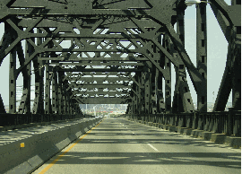
These 2002 photos offer a closer look of the trusswork from the roadway (left photo) and ground level (right photo). (Photos by Jim K. Georges.)
THE IMPACT OF THE SKYWAY: When it opened in 1932, the Pulaski Skyway earned design accolades from the American Institute of Steel Construction, which bestowed on the skyway the honor of "Most Beautiful Steel Structure" among long-span bridges. In addition to carrying US 1 and US 9, the elevated roadway carried the NJ 25 designation for its first two decades, and originally served as part of the easternmost portion of the transcontinental Lincoln Highway. Upon opening, the "Diagonal Highway" was renamed in honor of General Casimir Pulaski, the Polish-born brigadier general and cavalry leader who helped command the Revolutionary Army to victory over the British.
The Pulaski Skyway was an immediate success. From an excerpt in the February 1934 edition of Public Roads:
There is also every reason to believe that the traffic on the viaduct will increase during the next few years to a volume that could not have been adequately served by the old route.
During a one-year period ending in September 1933, the Bureau of Public Roads (the forerunner to the Federal Highway Administration) conducted a time study of delays between Jersey City and Newark, before and after the skyway opened. The report determined that the new bridge attracted traffic that had previously avoided other routes because of congestion. However, the skyway itself soon became congested: it took motorists as much as 45 minutes between Manhattan and Newark Airport.
TRUCKS ON THE SKYWAY: Almost immediately, extensive port operations developed in the immediate vicinity of the Pulaski Skyway, and the viaduct became an important truck route. However, the large number of truck accidents on the skyway prompted Jersey City Mayor Frank Hague to approve a ban on trucks, forcing trucks back into nearby Communipaw Avenue (which was subsequently designated TRUCK US 1-US 9). This ban was backed by the State Highway Commission in January 1934 and approved by local voters a month later.
Truckers took the ban to court, citing that because the skyway was built in part with Federal funds, local authorities had no authority to restrict truck traffic. On August 14, 1934, Justice Thomas W. Trenchard of the New Jersey Supreme Court upheld the ban:
The court is not at liberty to substitute its judgment for that of the municipality's as to the best and most feasible manner of curing traffic evils and traffic congestion where such regulation bears a direct relationship to public safety and is reasonable and not arbitrary.
During 1952, trucks were permitted to use the skyway temporarily during reconstruction of Communipaw Avenue.
OTHER SAFETY IMPROVEMENTS: During the 1950's, the state made a number of additional improvements to the Pulaski Skyway. In the early part of the decade, new approaches were built at the Newark end of the skyway to Raymond Boulevard, and later to the New Jersey Turnpike (I-95). In 1956, a new median barrier was added to prevent crossover accidents, and a new coat of pavement was applied to make the roadway less slippery. These measures, along with that year's opening of the New Jersey Turnpike-Newark Bay Extension (I-78), which provided some relief by reducing commute times as much as 50 percent, reduced the skyway's accident rate from an average 400 accidents per year.
A HISTORIC SPAN POTENTIALLY IN NEED OF REPLACEMENT: Now in service for more than three-quarters of a century, the Pulaski Skyway continues to fulfill its role as a major commuter route between Jersey City and Newark, carrying approximately 60,000 vehicles each day (AADT) according to the New Jersey Department of Transportation (NJDOT). Current plans call for $40 million in routine maintenance expenditures through 2010 to keep the viaduct in an updated state of repair, but inadequate design standards and weight restrictions still would preclude the use of the skyway by trucks.
In 2007, NJDOT Commissioner Kris Kolluri announced long-range plans to replace the existing Pulaski Skyway with a replacement structure. In a press interview, Kolluri said motorists would get "a new structure capable of handling the volume of traffic in a safe and efficient manner," and that new design features would "reflect the needs of the 21st century." Although the state allocated $135 million in its 2011 budget for the project, whose cost is projected to exceed $1 billion, it hopes to get much of the project funded by the Federal government.
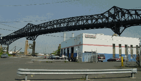
In addition to crossing the Passaic and Hackensack rivers, the Pulaski Skyway stands above a heavy industrial area on a low-lying coastal plain, as shown in this 2002 photo. (Photo by Jim K. Georges.)
A NEW BRIDGE THAT LOOKS THE SAME: The new Pulaski Skyway should be built to contemporary design standards with four 12-foot-wide lanes (two in each direction), left and right shoulders, a four-foot-high concrete median barrier, and adequate entrance and exit ramps. As these changes are incorporated into the new roadway design, the design of the new superstructure should be similar to the one that has been synonymous with industrial New Jersey since 1932.
Type of bridge: Construction started (original bridge): Opened to traffic (original bridge): Length of main cantilever spans (two main spans): Length of side cantilever spans (four side spans): Length of entire truss spans (two main and four side spans): Total length of all spans and approaches: Width of roadway: Clearance at center above mean high water: Structural material: Deck material (bridge and viaducts): Pier material (viaducts): Cost of original bridge:
Cantilever and truss March 1, 1930 November 24, 1932 550 feet 350 feet 1,250 feet 18,480 feet 44 feet 135 feet Steel Concrete and steel Reinforced concrete $20,000,000
SOURCES: "Great Express Highways" for New York Zone" by Waldo Walker, The New York Times (11/21/1926); "Two Jersey Bridges Get Approval," The New York Times (10/10/1929); "Bridge Award Won by Jersey Viaduct," The New York Times (5/20/1933); "Bars Trucks on Skyway," The New York Times (1/09/1934); "The Diagonal Highway," Public Roads (February 1934); Great American Bridges and Dams by Donald C. Jackson, Preservation Press-John Wiley and Sons (1988); "Routes 1 and 9: Struggling for Identity" by Steven M. Bedford and Paul Wojcik, National Trust for Historic Preservation (4/08/2000); "Pulaski Skyway Replacement Being Designed" by Michaelangelo Conte, The Jersey Journal (2/14/2007); New Jersey Department of Transportation; Phil Case; Ben Ellard; Nick Klissas; Lloyd Leone; Richard Lysiak; Raymond C. Martin; Dan Moraseski; Christof Spieler.
US 1 and US 9 shields by Ralph Herman. Lightposts by Jeff Saltzman.